- Bongo District
-
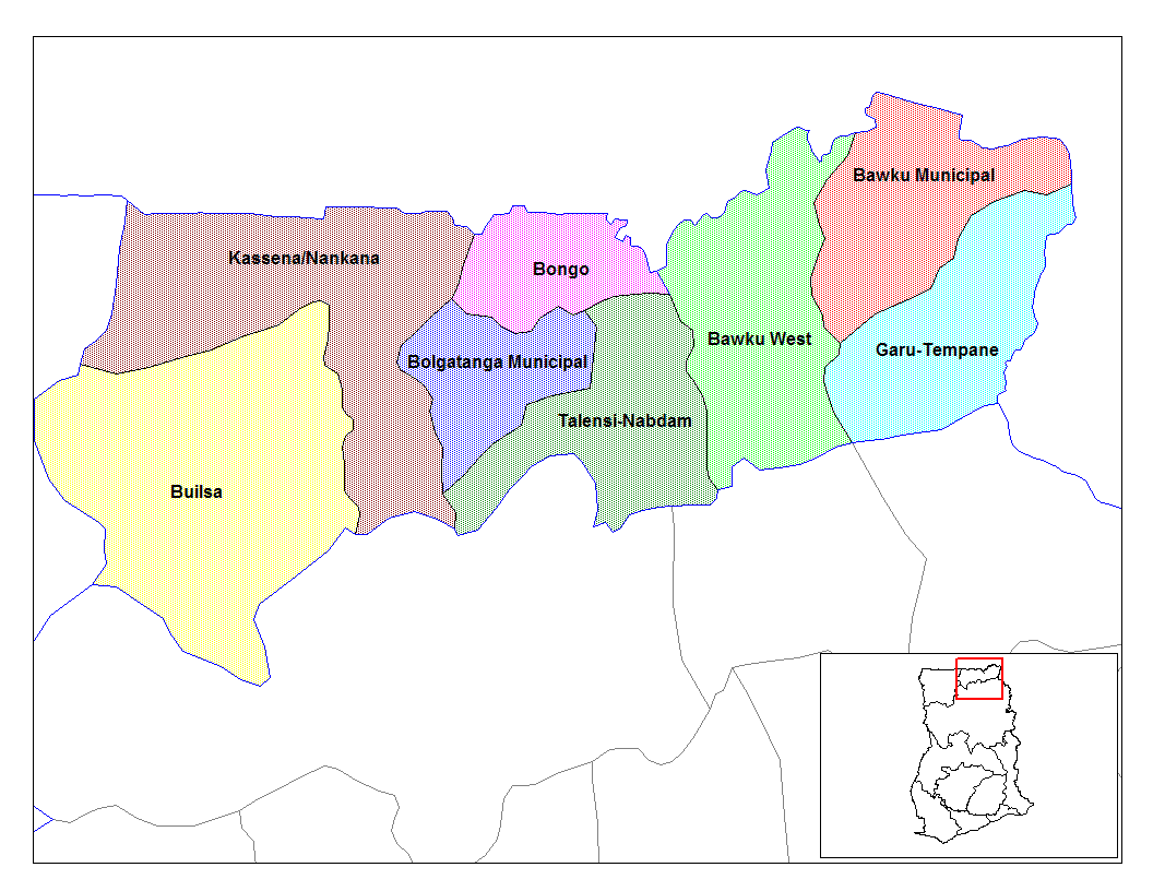
Bongo District 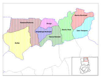 Lage des Distrikts Bongo innerhalb der Upper East Region
Land  Ghana
GhanaRegion Upper East Region Hauptstadt Bongo Distriktform Gewöhnlich District Chief Executive Francis A. Akurugu Fläche 488 km² km² Einwohnerzahl 77 894 (2002) ISO 3166-2 GH-UE-BO Der Bongo District im Nordosten Ghanas gehört zur Upper East Region. Der Distrikt hat eine gemeinsame Grenze mit dem Nachbarland Burkina Faso.
Inhaltsverzeichnis
Bevölkerung
Im Distrikt leben Angehörige der Ethnien der Bossi und der Frafra sprechenden Tallensi. Die Mehrheit der Bevölkerung hängt traditionellen Religionen an (53,6%) daneben gibt es 28,3% Christen und Anhänger des Islam (6,4%).
Klima und Vegetation
Das Klima ist tropisch mit einer feuchten Jahreszeit von Mai bis Oktober und einer langen Trockenzeit praktisch ohne Niederschlag von Oktober bis April. Die Temperaturen bewegen sich zwischen maximal 45° im März/April und minimal 12° im Dezember. Charakteristisch ist der heiße Harmattan, der während der Trockenzeit weht.
Wirtschaft
Der Distrikt ist landwirtschaftlich geprägt.
Ortschaften im Distrikt
- Soe Soboko
- Gowrie-Tingre
- Zoko Tarongo
- Lungu
- Dua
- Namoo
- Zoko-Kodorogo
- Bongo-Nyariga
- Zoko Kanga
- Adaboya
- Bogorogo
- Gowrie Nayire Central Zoko-Gambrongo-Azaabisi
- Zoko-Gambrongo
- Seo-Asabagabisi (Wabisi)
- Vea-Akugrebisi
- Zoko-Goo
- Dua Apuwongo
- Balungu-Gantorisi.
Siehe auch
Weblinks
 Distrikte der Upper East Region in Ghana
Bawku Municipal | Bawku West | Bolgatanga Municipal | Bongo | Builsa | Garu-Tempane | Kassena-Nankana | Talensi-Nabdam
Wikimedia Foundation.
Schlagen Sie auch in anderen Wörterbüchern nach:
Bongo District — is a district of Ghana near the city of Bolgatanga, Upper East Region, Ghana. (GH.UE.BO d in the [http://www.statoids.com/ihasc.html Hierarchical Administrative Subdivision Code] ). It shares borders with Burkina Faso to the North and East,… … Wikipedia
Bongo (district) — 10° 54′ 28″ N 0° 48′ 29″ W / 10.9078, 0.808056 … Wikipédia en Français
District de Bongo — Bongo (district) Pour les articles homonymes, voir Bongo (homonymie). Bongo Pays Ghana Région … Wikipédia en Français
Bongo — bezeichnet: Bongos, kubanische Trommeln Bongo (Antilope), eine Waldantilopenart Bongo (Volk), ein afrikanisches Volk Bongo (Sprache), eine afrikanische Sprache Bongo (Marke), ein amerikanisches Modelabel Bongo (Software), ein OpenSource… … Deutsch Wikipedia
Bongo (Homonymie) — Cette page d’homonymie répertorie les différents sujets et articles partageant un même nom … Wikipédia en Français
Bongo (homonymie) — Cette page d’homonymie répertorie les différents sujets et articles partageant un même nom. Sur les autres projets Wikimedia : « Bongo (homonymie) », sur le Wiktionnaire (dictionnaire universel) Sommaire … Wikipédia en Français
District (Ghana) — Les districts du Ghana sont, en 2009, au nombre de 170. La répartition territoriale du Ghana par districts a été entièrement réorganisée en 1988 1989 avec l objectif de décentraliser le gouvernement et lutter contre la corruption des… … Wikipédia en Français
Steady Bongo — Infobox musical artist Name = Steady Bongo Img capt = Img size = Landscape = Background = Birth name = Lansana Sheriff Alias = Born = Birth date and age|1966|8|28|mf=y Daru, Kailahun District, Sierra Leone Died = Band = Instrument = Genre =… … Wikipedia
Kailahun District — Infobox City official name = Kailahun District nickname = | subdivision type = Country subdivision type1 = Capital subdivision type2 = Province subdivision name = Sierra Leone subdivision name1 = Kailahun subdivision name2 = Eastern Province… … Wikipedia
Builsa District — Builsa Distrikt Land Ghana Region … Deutsch Wikipedia
Bongo District
18+
© Academic, 2000-2026
- Kontaktieren Sie uns: Unterstützung, Werbung
Wörterbücher Export, schritte mit PHP, Joomla, Drupal, WordPress, MODx.