- Bawku Municipal District
-
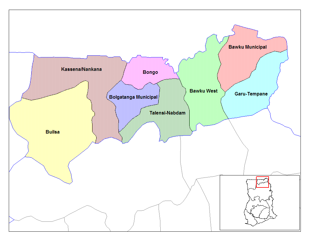
Bawku Municipal District 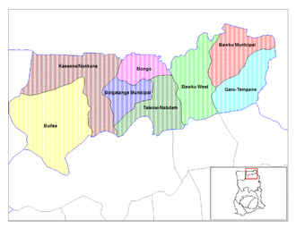 Lage des Distrikts Bawku Municipal District innerhalb der Upper East Region
Land  Ghana
GhanaRegion Upper East Region Hauptstadt Bawku Distriktform Municipal District Chief Executive Abdul-rahman Gumah Fläche 1215 km² km² Einwohnerzahl 205 849 (2002) Der Bawku Municipal District im Nordosten Ghanas gehört zur Upper East Region. Der Distrikt hat eine gemeinsame Grenze mit dem Nachbarländern Burkina Faso und Togo.
Inhaltsverzeichnis
Bevölkerung
Kusasi, Mamprussi, Bissas und Mossi sind die wichtigsten hier vertretenen Ethnien, wobei die Kussasi die Mehrheit der Bevölkerung stellen und die Mamprusi die nächstgrößere Gruppe bilden. Hinzu kommen Migranten aus Burkina Faso und aus dem Süden Ghanas. Die aus dem Süden Zugewanderten arbeiten überwiegend im öffentlichen Dienst. Zwischen Kusasi und Mamprussi ist es in den vergangenen Jahren mehrfach zu Auseinandersetzungen gekommen.
Wirtschaft
Der Distrikt ist landwirtschaftlich geprägt. Über die Selbstversiorgung der Bevölkerung hinaus werden Tomaten, Sojabohnen und Zwiebeln angebaut
Ortschaften im Distrikt
- Bawku
- Pusiga
- Garu
- Denugu/Danvorga
- Kongo
- Zorsi
- Tempane
- Wuriyanga
- Narango
- Mognori (Gumbo)
- Widana
- Yabrago
- Missiga
- Bugri-Bulpielse
- Manga
- Basyonde
- Binduri Natinga
- Kulugungu
- Gozesi
- Bugri.
Siehe auch
Weblinks
 Distrikte der Upper East Region in Ghana
Bawku Municipal | Bawku West | Bolgatanga Municipal | Bongo | Builsa | Garu-Tempane | Kassena-Nankana | Talensi-Nabdam
Wikimedia Foundation.
Schlagen Sie auch in anderen Wörterbüchern nach:
Bawku Municipal District — The PAGENAME is one of the eight districts in the Upper East Region of Ghana.ources* … Wikipedia
Bawku West District — Land Ghana Region Up … Deutsch Wikipedia
Bolgatanga Municipal District — Land Ghana Region … Deutsch Wikipedia
Bawku municipalité — Pays Ghana Région Région du Haut Ghana oriental Catégorie de District Municipal Gouverneur Abdul rahman Gumah … Wikipédia en Français
Bawku Central (Ghana parliament constituency) — Ghana constituency infobox Name = Bawku Central Map1 = Map2 = Ghana UpperEast Year = District = Bawku Municipal District Region = Upper East Region MP = Mahama Ayariga Party = National Democratic CongressBawku Central is one of the constituencies … Wikipedia
Bawku — Infobox Settlement official name = Bawku other name = native name = nickname = settlement type = motto = imagesize = 300px image caption = flag size = image seal size = image shield = shield size = image blank emblem = blank emblem type = blank… … Wikipedia
District de Bongo — Bongo (district) Pour les articles homonymes, voir Bongo (homonymie). Bongo Pays Ghana Région … Wikipédia en Français
District (Ghana) — Les districts du Ghana sont, en 2009, au nombre de 170. La répartition territoriale du Ghana par districts a été entièrement réorganisée en 1988 1989 avec l objectif de décentraliser le gouvernement et lutter contre la corruption des… … Wikipédia en Français
Builsa District — Builsa Distrikt Land Ghana Region … Deutsch Wikipedia
Kassena-Nankana District — Land Ghana Region … Deutsch Wikipedia
Bawku Municipal District
18+
© Academic, 2000-2026
- Kontaktieren Sie uns: Unterstützung, Werbung
Wörterbücher Export, schritte mit PHP, Joomla, Drupal, WordPress, MODx.