Boulia Shire Council

Boulia Shire Council
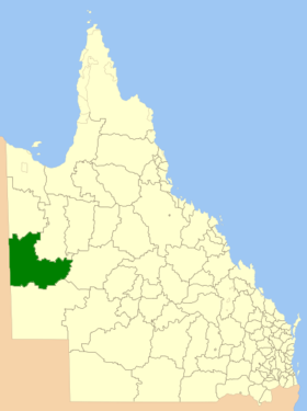
Boulia LGA Qld.png
Lage des Boulia Shire in Queensland
Gliederung
Staat: Australien Australien
Bundesstaat: Flag of Queensland.svg Queensland
Verwaltungssitz: Boulia
Daten und Zahlen
Fläche: 61.176 km²
Einwohner: 419 (2006) [1]
Bevölkerungsdichte: 0,007 Einwohner je km²
-22.9139.9

Boulia Shire ist ein lokales Verwaltungsgebiet (LGA) im australischen Bundesstaat Queensland. Das Gebiet liegt im Südwesten und umfasst 61.000 km². Die größte Stadt und auch der Sitz der Verwaltung ist Boulia. Die zweite Stadt im Shire ist Urandangi. Die Einwohnerzahl ist von 2001 auf 2006 von 640 auf 419 zurückgegangen.

Weblinks

Einzelnachweise

  1. Australian Bureau of Statistics (25. Oktober 2007): Boulia (S) (Local Government Area) (Englisch). 2006 Census QuickStats. Abgerufen am 4. April 2009.

Wikimedia Foundation.

Игры ⚽ Поможем сделать НИР

Schlagen Sie auch in anderen Wörterbüchern nach:

  • Boulia Shire Council — Infobox Australian Place | type = lga name = Boulia Shire Council state = qld imagesize= 180 caption = Location in Queensland pop = 640 (2001 census) area = 61176 est = seat = Boulia mayor = Trevor Jones region = url =… …   Wikipedia

  • Cloncurry Shire Council — Infobox Australian Place | type = lga name = Cloncurry Shire Council state = qld imagesize= 180 caption = Location in Queensland pop = 3,841 [ [http://www.abs.gov.au/ausstats/abs@.nsf/Latestproducts/3218.0Main%20Features42004 05?opendocument… …   Wikipedia

  • Diamantina Shire Council — Infobox Australian Place | type = lga name = Diamantina Shire Council state = qld imagesize= 180 caption = Location in Queensland pop = 434 (2001 census) area = 95000 est = seat = Bedourie mayor = Robert Dare region = url =… …   Wikipedia

  • Boulia — Boulia, Ortseingangsschild Staat …   Deutsch Wikipedia

  • Winton Shire Council — Infobox Australian Place | type = lga name = Winton Shire state = qld imagesize= 180 caption = Location within Queensland pop = 1,939 area = est = seat = Winton mayor = Bruce Collins region = url = stategov = Mount Isa fedgov = Maranoa near nw =… …   Wikipedia

  • Shire of Croydon — Queensland Location within Queensland Population …   Wikipedia

  • Shire of Nebo — Queensland Location within Queensland Population: 2,520 (20 …   Wikipedia

  • Shire of Cloncurry — Queensland Location within Queensland Population …   Wikipedia

  • Shire of McKinlay — Queensland Location within Queensland Population …   Wikipedia

  • Shire of Cook — Queensland Location within Queensland Population: 3,976(201 …   Wikipedia

Share the article and excerpts

Direct link
Do a right-click on the link above
and select “Copy Link”