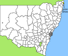
Byron Shire

Byron Shire
Shire of Byron
Australia-Map-NSW-LGA-Byron.png
Lage des Byron Shire in New South Wales
Gliederung
Staat: Australien Australien
Bundesstaat: Flag of New South Wales.svg New South Wales
Verwaltungssitz: Mullumbimby
Daten und Zahlen
Fläche: 567 km²
Einwohner: 28.766 (2006) [1]
Bevölkerungsdichte: 51 Einwohner je km²
-28.55153.5

Byron Shire ist ein lokales Verwaltungsgebiet (LGA) im australischen Bundesstaat New South Wales. Das Gebiet ist 567 km² groß und hat etwa 29.000 Einwohner.

Byron liegt im äußersten Nordosten des Staates an der Pazifikküste etwa 790 km nördlich der Metropole Sydney und 150 km südlich von Brisbane. Das Gebiet umfasst 58 Ortsteile und Ortschaften, darunter Bangalow, Billinudgel, Brunswick Heads, Byron Bay, Federal, Mullumbimby, Ocean Shores, South Golden Beach, Suffolk Park, Yelgun und Teile von Clunes und Newrybar. Der Sitz des Shire Councils befindet sich in der Stadt Mullumbimby, wo etwa 3.100 Einwohner leben.

Cape Byron ist der östlichste Punkt des australischen Kontinents.

Verwaltung

Der Byron Shire Council hat zehn Mitglieder, neun Councillor und ein Vorsitzender und Mayor (Bürgermeister), die von den Bewohnern der LGA gewählt werden. Byron ist nicht in Bezirke untergliedert.

Weblinks

Einzelnachweise

  1. Australian Bureau of Statistics (25. Oktober 2007): Byron (A) (Local Government Area) (Englisch). 2006 Census QuickStats. Abgerufen am 6. April 2010.

Wikimedia Foundation.

Игры ⚽ Поможем сделать НИР

Schlagen Sie auch in anderen Wörterbüchern nach:

  • Byron Shire — Admin ASC 2 Code Orig. name Byron Shire Country and Admin Code AU.02.11350 AU …   World countries Adminstrative division ASC I-II

  • Byron Shire Council — Infobox Australian Place type = lga name = Byron Shire Council city = state = nsw imagesize = 270 caption = Location in New South Wales pop = 28,766 pop footnotes = [Census 2006 AUS|id=LGA11350|name=Byron (A) (Local Government… …   Wikipedia

  • Byron Shire Echo — Infobox Newspaper name = caption = Typical Echo front page type = Weekly newspaper format = Tabloid foundation = 1986 owners = The Shand Family, David Lovejoy, some staff and Private Media (20%) political = Progressivism headquarters = Village… …   Wikipedia

  • Byron Bay — Staat …   Deutsch Wikipedia

  • Byron Bay, New South Wales — Infobox Australian Place | type = town name = Byron Bay state = nsw caption = Byron Lighthouse lga = Byron Shire Council postcode = 2481 pop = 5,609Census 2006 AUS|id=SSC16597|name=Byron Bay (State Suburb)|accessdate=2007 09 05|quick=on] mayor =… …   Wikipedia

  • Byron Bay — ▪ New South Wales, Australia       town, northeastern New South Wales, Australia. The town is situated on Cape Byron, easternmost point of the Australian mainland, which shelters Byron Bay and was discovered in 1770 by Captain James Cook, who… …   Universalium

  • Tweed Shire Council — Infobox Australian Place | type = lga name=Tweed Shire caption = Location in New South Wales state=nsw region=Northern Rivers area=1309 area footnotes= cite web title=Tweed Shire Council publisher = Department of Local Government url = http://www …   Wikipedia

  • Bay FM (Byron Bay) — Bay FM (call sign: 2BAY) is a community radio station serving the Byron Shire and beyond from Byron Bay, New South Wales, Australia.Totally volunteer run, Bay FM aims to provide independent community responsive radio informing and entertaining… …   Wikipedia

  • Wakool Shire — Shire of Wakool New South Wales Location in New South Wales Population: 4,427(2009) …   Wikipedia

  • Muswellbrook Shire — New South Wales Location in New South Wales Population …   Wikipedia

Share the article and excerpts

Direct link
Do a right-click on the link above
and select “Copy Link”