- Amphoe Sap Yai
-
Sap Yai
ซับใหญ่Provinz: Chaiyaphum Fläche: 171,0 km² Einwohner: 13.466 (2005) Bev.dichte: 78,8 E./km² PLZ: 36130 Geocode: 3616 Karte 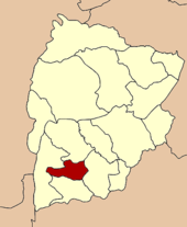
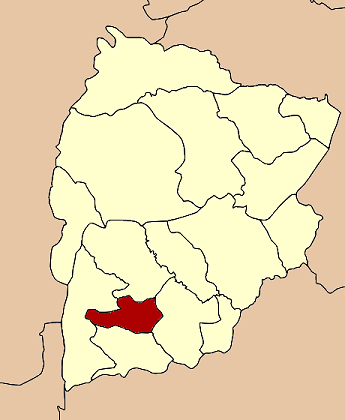
Amphoe Sap Yai (Thai:อำเภอ ซับใหญ่) ist ein Landkreis (Amphoe - Verwaltungs-Distrikt) der Provinz Chaiyaphum. Die Provinz Chaiyaphum liegt in der Nordostregion von Thailand, dem so genannten Isaan.
Inhaltsverzeichnis
Geographie
Die Nachbarbezirke sind im Uhrzeigersinn von Norden startend: die Amphoe Nong Bua Rawe, Chatturat, Bamnet Narong und Thep Sathit. Alle Amphoe liegen in der Provinz Chaiyaphum.
Geschichte
Sap Yai wurde am 1. Juli 1997 zunächst als Unterbezirk (King Amphoe) eingerichtet, indem er vom Amphoe Chatturat abgetrennt wurde. [1].
Am 15. Mai 2007 hatte die thailändische Regierung beschlossen, alle 81 King Amphoe in den einfachen Amphoe-Status zu erheben, um die Verwaltung zu vereinheitlichen. [2] Mit der Veröffentlichung in der Royal Gazette „Issue 124 chapter 46“ vom 24. August 2007 trat dieser Beschluss offiziell in Kraft. [3]
Verwaltung
Amphoe Sap Yai ist in drei Gemeinden (Tambon) unterteilt, die wiederum aus 37 Dörfern (Muban) bestehen.
Außerdem gibt es drei „Tambon Administrative Organizations“ (TAO, องค์การบริหารส่วนตำบล – Verwaltungs-Organisationen).
Nr. Name Thai Muban Einw. 1. Sap Yai ซับใหญ่ 14 6.097 2. Tha Kup ท่ากูบ 12 4.177 3. Tako Thong ตะโกทอง 11 3.192 Einzelnachweise
- ↑ ประกาศกระทรวงมหาดไทย เรื่อง แบ่งเขตท้องที่อำเภอจัตุรัส จังหวัดชัยภูมิ ตั้งเป็นกิ่งอำเภอซับใหญ่. In: Royal Gazette. 114, Nr. Spezial (พิเศษ) 51 ง, 25. Juni 1997, S. 6.
- ↑ www.manager.co.th
- ↑ พระราชกฤษฎีกาตั้งอำเภอฆ้องชัย...และอำเภอเหล่าเสือโก้ก พ.ศ. ๒๕๕๐ Royal Gazette, Band 124, Ausg. 46 ก vom 24. August 2007, S. 14-21 (in Thai)
Weblinks
 Amphoe der Provinz Chaiyaphum
Mueang Chaiyaphum | Ban Khwao | Khon Sawan | Kaset Sombun | Nong Bua Daeng | Chatturat | Bamnet Narong | Nong Bua Rawe | Thep Sathit | Phu Khiao | Ban Thaen | Kaeng Khro | Khon San | Phakdi Chumphon | Noen Sa-nga | Sap Yai
Wikimedia Foundation.
Schlagen Sie auch in anderen Wörterbüchern nach:
Amphoe Sap Yai — Admin ASC 2 Code Orig. name Amphoe Sap Yai Country and Admin Code TH.26.7510728 TH … World countries Adminstrative division ASC I-II
Amphoe Sap Yai — Infobox Amphoe thai=ซับใหญ่ name=Sap Yai province=Chaiyaphum coordinates=coord|15|38|30|N|101|37|48|E|type:adm2nd region:TH area=171.0 capital=Sap Yai population=13,466 population as of=2005 density=78.8 postal code=36130 geocode=3616Sap Yai ( th … Wikipedia
Sap Yai — Original name in latin Sap Yai Name in other language Amphoe Sap Yai, King Amphoe Sap Yai, Sap Yai State code TH Continent/City Asia/Bangkok longitude 15.63739 latitude 101.61671 altitude 344 Population 0 Date 2012 01 21 … Cities with a population over 1000 database
Amphoe Thep Sathit — Thep Sathit เทพสถิต Provinz: Chaiyaphum Fläche: 875,6 km² Einwohner: 65.735 (2005) Bev.dichte: 75.1 E./km² PLZ: 36230 … Deutsch Wikipedia
Amphoe Mueang Chaiyaphum — Mueang Chaiyaphum เมืองชัยภูมิ Provinz: Chaiyaphum Fläche: 1169,9 km² Einwohner: 184.921 (2000) Bev.dichte: 158,1 E./km² PLZ … Deutsch Wikipedia
Amphoe Chatturat — Chatturat จัตุรัส Provinz: Chaiyaphum Fläche: 731.0 km² Einwohner: 74,548 (2000) Bev.dichte: 102.0 E./km² PLZ: 36130 … Deutsch Wikipedia
Amphoe Bamnet Narong — Bamnet Narong บำเหน็จณรงค์ Provinz: Chaiyaphum Fläche: 560,3 km² Einwohner: 54.750 (2000) Bev.dichte: 97,7 E./km² PLZ: 361 … Deutsch Wikipedia
Amphoe Nong Bua Rawe — Nong Bua Rawe หนองบัวระเหว Provinz: Chaiyaphum Fläche: 841,8 km² Einwohner: 33.631 (2000) Bev.dichte: 40,0 E./km² PLZ: 362 … Deutsch Wikipedia
Amphoe Chatturat — Infobox Amphoe thai=จัตุรัส name=Chatturat province=Chaiyaphum coordinates=coord|15|33|56|N|101|50|44|E|type:adm2nd region:TH area=731.0 population=74,548 population as of=2000 density=102.0 capital= location= postal code=36130… … Wikipedia
Amphoe Nong Bua Daeng — Nong Bua Daeng หนองบัวแดง Provinz: Chaiyaphum Fläche: 2215,5 km² Einwohner: 92.766 (2000) Bev.dichte: 41,9 E./km² PLZ: 362 … Deutsch Wikipedia
Amphoe Sap Yai

18+
© Academic, 2000-2026
- Kontaktieren Sie uns: Unterstützung, Werbung
Wörterbücher Export, schritte mit PHP, Joomla, Drupal, WordPress, MODx.