- Amphoe Phakdi Chumphon
-
Phakdi Chumphon
ภักดีชุมพลProvinz: Chaiyaphum Fläche: 900,4 km² Einwohner: 28.111 (2000) Bev.dichte: 31,2 E./km² PLZ: 36260 Geocode: 3614 Karte 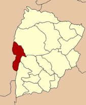
Amphoe Phakdi Chumphon (Thai: อำเภอ ภักดีชุมพล) ist der westlichste Landkreis (Amphoe - Verwaltungs-Distrikt) der Provinz Chaiyaphum. Die Provinz Chaiyaphum liegt in der Nordostregion von Thailand, dem so genannten Isaan.
Inhaltsverzeichnis
Geographie
Die Kreisverwaltung liegt etwa 70 Kilometer westlich der Provinzhauptstadt Chaiyaphum.
Benachbarte Distrikte (von Norden im Uhrzeigersinn): die Amphoe Nong Bua Daeng, Nong Bua Rawe und Thep Sathit der Provinz Chaiyaphum sowie die Amphoe Wichian Buri, Bueng Sam Phan und Nong Phai in der Provinz Phetchabun.
Geschichte
Am 1. August 1988 wurde Phakdi Chumphon zunächst als Unterbezirk (King Amphoe) eingerichtet, indem die Tambon Ban Chiang, Wang Thong und Chao Thaong des Amphoe Nong Bua Daeng abgetrennt wurden. [1] Am 7. September 1995 bekam Phakdi Chumphon den vollen Amphoe-Status. [2]
Verwaltung
Der Kreis ist in vier Kommunen (Tambon) eingeteilt, die sich weiter in 47 Dörfer (Muban) unterteilen.
Außerdem gibt es vier „Tambon Administrative Organizations“ (TAO, องค์การบริหารส่วนตำบล – Verwaltungs-Organisationen) im Landkreis.
Nr. Name Thai 1. Ban Chiang บ้านเจียง 2. Chao Thong เจาทอง 3. Wang Thong วังทอง 4. Laem Thong แหลมทอง Einzelnachweise
- ↑ ประกาศกระทรวงมหาดไทย เรื่อง แบ่งท้องที่อำเภอหนองบัวแดง จังหวัดชัยภูมิ ตั้งเป็นกิ่งอำเภอภักดีชุมพล. In: Royal Gazette. 105, Nr. 89 ง ฉบับพิเศษ( special), June 1 1988, S. 3.
- ↑ พระราชกฤษฎีกาตั้งอำเภอด่านมะขามเตี้ย อำเภอแก่งหางแมว อำเภอภักดีชุมพล อำเภอเวียงแก่น อำเภอแม่วาง อำเภอถ้ำพรรณรา อำเภอบ่อเกลือ อำเภอโนนสุวรรณ อำเภอห้วยราช อำเภอแม่ลาน อำเภอบางแก้ว อำเภอป่าพะยอม อำเภอหนองม่วงไข่ อำเภอยางสีสุราช อำเภอจังหาร อำเภอบ้านธิ อำเภอภูสิงห์ อำเภอบางกล่ำ อำเภอวังม่วง และอำเภอนายูง พ.ศ. ๒๕๓๘. In: Royal Gazette. 112, Nr. 32 ก, August 8 1995, S. 1–3.
Weblinks
 Amphoe der Provinz Chaiyaphum
Mueang Chaiyaphum | Ban Khwao | Khon Sawan | Kaset Sombun | Nong Bua Daeng | Chatturat | Bamnet Narong | Nong Bua Rawe | Thep Sathit | Phu Khiao | Ban Thaen | Kaeng Khro | Khon San | Phakdi Chumphon | Noen Sa-nga | Sap Yai
Wikimedia Foundation.
Schlagen Sie auch in anderen Wörterbüchern nach:
Amphoe Phakdi Chumphon — Infobox Amphoe thai=ภักดีชุมพล name=Phakdi Chumphon province=Chaiyaphum coordinates=coord|15|54|18|N|101|25|18|E|type:adm2nd region:TH area=900.4 population=28,111 population as of=2000 density=31.2 capital=Chao Thong postal code=36260… … Wikipedia
Amphoe Phakdi Chumphon — Admin ASC 2 Code Orig. name Amphoe Phakdi Chumphon Country and Admin Code TH.26.7510715 TH … World countries Adminstrative division ASC I-II
Phakdi Chumphon — Original name in latin Phakdi Chumphon Name in other language Amphoe Phakdi Chumphon, King Amphoe Phakdi Chumphon, Phakdi Chumphon, phakdi chumphl State code TH Continent/City Asia/Bangkok longitude 15.90517 latitude 101.42228 altitude 275… … Cities with a population over 1000 database
Amphoe Nong Bua Daeng — Nong Bua Daeng หนองบัวแดง Provinz: Chaiyaphum Fläche: 2215,5 km² Einwohner: 92.766 (2000) Bev.dichte: 41,9 E./km² PLZ: 362 … Deutsch Wikipedia
Amphoe Thep Sathit — Thep Sathit เทพสถิต Provinz: Chaiyaphum Fläche: 875,6 km² Einwohner: 65.735 (2005) Bev.dichte: 75.1 E./km² PLZ: 36230 … Deutsch Wikipedia
Amphoe Mueang Chaiyaphum — Mueang Chaiyaphum เมืองชัยภูมิ Provinz: Chaiyaphum Fläche: 1169,9 km² Einwohner: 184.921 (2000) Bev.dichte: 158,1 E./km² PLZ … Deutsch Wikipedia
Amphoe Mueang Chaiyaphum — Infobox Amphoe name=Mueang Chaiyaphum thai=เมืองชัยภูมิ province=Chaiyaphum coordinates=coord|15|48|35|N|102|1|13|E|type:adm2nd region:TH area=1,169.9 population=184,921 population as of=2000 density=158.1 postal code=36000 geocode=3601Mueang… … Wikipedia
Amphoe Nong Bua Rawe — Nong Bua Rawe หนองบัวระเหว Provinz: Chaiyaphum Fläche: 841,8 km² Einwohner: 33.631 (2000) Bev.dichte: 40,0 E./km² PLZ: 362 … Deutsch Wikipedia
Amphoe Nong Bua Daeng — Infobox Amphoe name=Nong Bua Daeng thai=หนองบัวแดง province=Chaiyaphum coordinates=coord|16|4|54|N|101|48|12|E|type:adm2nd region:TH capital=Nong Bua Daeng area=2,215.5 population=92,766 population as of=2000 density=41.9 postal code=36210… … Wikipedia
Amphoe Bueng Sam Phan — Bueng Sam Phan บึงสามพัน Provinz: Phetchabun Fläche: 489,8 km² Einwohner: 66.613 (2000) Bev.dichte: 136 E./km² PLZ: 67160 … Deutsch Wikipedia
Amphoe Phakdi Chumphon


18+
© Academic, 2000-2026
- Kontaktieren Sie uns: Unterstützung, Werbung
Wörterbücher Export, schritte mit PHP, Joomla, Drupal, WordPress, MODx.