Annoatok

Annoatok
Annoatok (vom Wind geliebter Ort)
Kommune Qaasuitsup Kommunia
Geographische Lage 78° 19′ 48″ N, 72° 18′ 0″ W78.33-72.3340Koordinaten: 78° 19′ 48″ N, 72° 18′ 0″ W
Annoatok (Grönland)
Annoatok
Höhe 340 m
Einwohner 0 (aufgegeben)
Zeitzone UTC-4
Besonderheiten bis ins 20. Jahrhundert nördlichste natürliche Siedlung der Welt

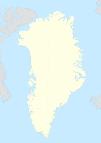
Annoatok (oder Anoritooq), gelegen auf 78,33 Grad N und 72,30 Grad W, war ein kleines Inuitdorf im Nordwesten von Grönland, am Smithsund, ungefähr 24 Kilometer nördlich von Etah im Nordwesten der Hayes-Halbinsel. Annoatok wurde im 20. Jahrhundert als Dauersiedlung aufgegeben, es war bis dahin die nördlichste natürliche Siedlung der Welt.

Geschichte

Frederick Cook nutzte Annoatok als Basis seiner Polarexpedition 1908/09[1], nach der er behauptete, den Nordpol erreicht zu haben.[2] Der Name Annoatok bedeutet „vom Wind geliebter Ort“.

Einzelnachweise

  1. Wo Norden Süden ist, Der Spiegel, Heft 9/1954 vom 24. Februar 1954
  2. Ulli Kulke, Schlammschlacht im arktischen Eis, Die Welt vom 15. November 2009.

Wikimedia Foundation.

Игры ⚽ Нужна курсовая?

Schlagen Sie auch in anderen Wörterbüchern nach:

  • Annoatok — (or Anoritooq)), latitude 78°33 N and longitude 72°30 W [ [http://www.antarctica.org/old/UK/Expe/Pag hubert/Transarctic 02 UK/dias/cook peary.htm The first conqueror of the North Pole: Cook, Peary, or neither? by Jacques L Theodor] ] , was a… …   Wikipedia

  • Frederick Cook — For other people named Frederick Cook, see Frederick Cook (disambiguation). Frederick Albert Cook Cook on South Michigan Avenue in Chicago Born June 10, 1865(1865 06 10) …   Wikipedia

  • Smithsund — Lage des Smithsunds Verbindet Gewässer Baffin Bay mit Gewässer K …   Deutsch Wikipedia

  • Qaanaaq — NOTOC Qaanaaq (pronounced|qaːnaːq) is a town and municipality in northwestern Greenland. It is the only town and the only municipality in the county of North Greenland (Avannaa). Qaanaaq was founded when the US extended their current airbase at… …   Wikipedia

  • Northernmost settlements — Some of the northernmost settlements in the world are: Location Latitude Population Public Settlement? Active? Description Barneo, Arctic Ocean Ice Sheet 88°11 N 100 no yes Latitude as of April 2009 (varies), Russian Ice Camp, populated in summer …   Wikipedia

  • Thule Air Base — Infobox Airport name = Thule Air Base nativename = Part of Air Force Space Command (AFSPC) nativename a = nativename r = image width = 250 caption = IATA = THU ICAO = BGTL type = Military owner = operator = United States Air Force city served =… …   Wikipedia

  • North Ice — …   Wikipedia

  • Ivittuut — The cryolite mine in Ivittuut in 1940 …   Wikipedia

  • Pituffik — Pituffik …   Wikipedia

  • Comer's Midden — Created Thule culture Discovered 1916 Present location Near Pituffik, Greenland …   Wikipedia

Share the article and excerpts

Direct link
Do a right-click on the link above
and select “Copy Link”