Antelope Island (Utah)

Antelope Island (Utah)
Antelope Island
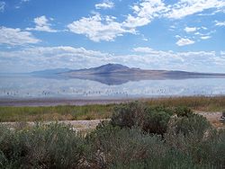
Antelope Island vom Damm aus gesehen
Gewässer Großer Salzsee
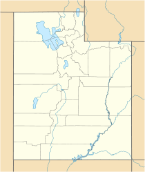
Geographische Lage 40° 57′ N, 112° 13′ W40.951388888889-112.212010Koordinaten: 40° 57′ N, 112° 13′ W
Antelope Island (Utah)
Antelope Island
Länge 24 km
Breite 7,8 km
Fläche 109 km²
Höchste Erhebung Frary Peak
2.010 m
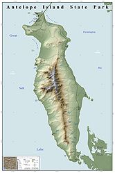
Karte von Antelope Island

Antelope Island ist die größte Insel im Großen Salzsee (Great Salt Lake) im US-Bundesstaat Utah. Administrativ gehört die Insel zum Davis County.

Inhaltsverzeichnis

Geographie

Antelope Island liegt im Südosten des Sees und ist über einen 11 km langen Damm mit dem Festland in Richtung Syracuse verbunden. Die Insel ist in Nord-Süd-Richtung 24 km lang, in Ost-West-Richtung bis zu 7,8 km breit und weist eine Fläche von 109 km² auf. Höchster Punkt der Insel ist der Frary Peak mit 2011 m über dem Meer, was einer Höhe von 762 m über dem Seelevel entspricht. Die Höhe der Küstenlinie der Insel liegt bei etwa bei 1250 m über dem Meer,[1] wobei über die Jahre Schwankungen des Seepegels um mehrere Meter vorkommen.

Geschichte

Archäologische Funde auf der Insel deuten darauf hin, dass die Insel schon vor etwa 6000 Jahren von Menschen besucht wurde. Die ersten Zeugnisse von weißen Forschern stammen von dem Fallensteller Jim Bridger und dem Forscher Etienne Provost, die die Gegend um 1820 beschrieben, der Insel aber keinen weißen Namen gaben. Erst 1845 wagten sich die Pioniere John Charles Frémont und Kit Carson bei niedrigem Wasserstand mit ihren Pferden auf die Insel und benannten sie nach dort vorkommenden Pronghorn-Antilopen.

There is at this southern end of the lake a large peninsular island which the Indians informed me could at this low stage of the water be reached on horseback. Accordingly … I took with me (Kit) Carson and a few men and rode across the shallows. On the island we found grass and water and several bands of antelope. Some of these were killed, and in memory of the grateful supply of food they furnished, I gave their name to the island.

John C. Frémont

1969 wurden die ersten 2000 acres (809 ha) im Norden der Insel wegen des Potentials als Erholungsgebiet vom Bundesstaat übernommen. 1981 wurden fast die ganze restliche Fläche erworben und zum Antelope Island State Park deklariert.[2] Im Jahr 2005 wurden auf der Insel jeweils 200 Pronghorn-Antilopen und Dickhornschafe, 250 Maultierhirsche und 300.000 menschliche Besucher gezählt.[3]

Weblinks

 Commons: Antelope Island – Sammlung von Bildern, Videos und Audiodateien

Verweise

  1. http://stateparks.utah.gov/stateparks/parks/antelope-island/about.html
  2. http://www.buffalorun.org/history.html
  3. http://www.ksl.com/?nid=148&sid=125801

Wikimedia Foundation.

Игры ⚽ Нужен реферат?

Schlagen Sie auch in anderen Wörterbüchern nach:

  • Antelope Island — ist der Name mehrerer Inseln in den Vereinigten Staaten: Antelope Island (Arizona) Antelope Island (South Dakota) Antelope Island (Utah) und des Antelope Island State Park auf der gleichnamigen Insel in Utah …   Deutsch Wikipedia

  • Antelope Island — Antelope Island, with an area of 42 square miles (68 km²), is the largest island in the Great Salt Lake, the largest lake in the Western United States [Czerny, Peter G. (1976). The great Great Salt Lake . Provo, Utah: Brigham Young University… …   Wikipedia

  • Antelope Island State Park — Karte des Antelope Island State Park Der Antelope Island State Park ist ein State Park im Davis County in Utah. Er befindet sich auf Antelope Island, der größten Insel im Großen Salzsee, und ist über einen befahrbaren Damm mit dem Festland in… …   Deutsch Wikipedia

  • Antelope Island — Parc d État d Antelope Island Parc d État d Antelope Island Catégorie V de la CMAP (Paysage terrestre/marin protégé) [1] Pays …   Wikipédia en Français

  • Parc d'État d'Antelope Island — Catégorie UICN II (parc national) Identifiant 365301 Pays …   Wikipédia en Français

  • Parc d'Etat d'Antelope Island — Parc d État d Antelope Island Parc d État d Antelope Island Catégorie V de la CMAP (Paysage terrestre/marin protégé) [1] Pays …   Wikipédia en Français

  • Utah State Route 127 — Infobox road state=UT type=SR route=127 section=118 maint=UDOT length mi=2.507 length round=3 length ref=cite web | title=State Route 127 Highway reference | publisher=Utah Department of Transportation |… …   Wikipedia

  • Utah — This article is about the U.S. state of Utah. For other uses, see Utah (disambiguation). State of Utah …   Wikipedia

  • Utah Lake — Utahsee Blick auf den Utahsee …   Deutsch Wikipedia

  • Utah State Route 108 — Infobox road state=UT type=SR route=108 section=116 maint=UDOT length mi=12.920 length round=3 length ref=cite web | title=State Route 108 Highway reference | publisher=Utah Department of Transportation |… …   Wikipedia

Share the article and excerpts

Direct link
Do a right-click on the link above
and select “Copy Link”