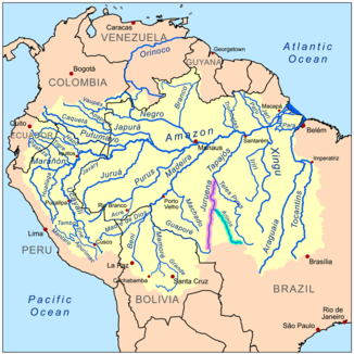
Arinos

Arinos
Rio Arinos
Juruena (rosa) und Arinos (hellblau)

Juruena (rosa) und Arinos (hellblau)Vorlage:Infobox Fluss/KARTE_fehlt

DatenVorlage:Infobox Fluss/GKZ_fehlt
Lage Mato Grosso, Brasilien
Flusssystem Amazonas
Abfluss über Rio Juruena → Rio Tapajós → Amazonas → Atlantik
Quelle in der Serra AzulVorlage:Infobox Fluss/QUELLKOORDINATE_fehltVorlage:Infobox Fluss/QUELLHÖHE_fehlt
Mündung in den Rio Juruena
-10.413533832862-58.330535888672

10° 24′ 49″ S, 58° 19′ 50″ W-10.413533832862-58.330535888672
Vorlage:Infobox Fluss/MÜNDUNGSHÖHE_fehltVorlage:Infobox Fluss/HÖHENUNTERSCHIED_fehlt
Länge ca. 580 kmVorlage:Infobox Fluss/NACHWEISE_fehlenVorlage:Infobox Fluss/EINZUGSGEBIET_fehlt

Vorlage:Infobox Fluss/ABFLUSS_fehlt

Der Arinos (portugiesisch rio Arinos [ˌχiu aˈɾinuz]) ist ein rechter Zufluss des Rio Juruena in Mato Grosso in Brasilien.

Flusslauf

Der Arinos entspringt östlich von Diamantino in der Serra Azul[1]. Von dort durchfließt er den Bundesstaat Mato Grosso in nordwestlicher Richtung bis er in den Rio Juruena mündet. Zu seinen wichtigsten Nebenflüssen gehören im Oberlauf der Agua Verde[1] (links), der Parecis[1] (links), der Rio dos Patos[1] (rechts), und der Rio Petro[2], der Sumidor im Mittellauf[2] sowie der Rio dos Peixes[1] (rechts) im Unterlauf. Im Mittel- und Unterlauf fließt zwischen den teilweise zu ihm parallel verlaufenden Bergketten Serra dos Caiabis und Serra do Tombador hindurch. Sowohl im Oberlauf als auch im Unterlauf existieren eine Vielzahl von Stromschnellen[1].

Der erste Europäer, der den Arinos entdeckte und befuhr, war Joam de Souza e Azevedo.[2]

Einzelnachweise

  1. a b c d e f Kümmerly+Frey: The New Internatiolal Atlas. Rand McNally (1980), S. 249.
  2. a b c James Henderson: A History of Brazil. Longman, Hurst, Rees, Orme, and Brown 1821, S. 227–299 (vollständige Online-Version (Google Books)).

Wikimedia Foundation.

Игры ⚽ Поможем написать реферат

Schlagen Sie auch in anderen Wörterbüchern nach:

  • Arinos — is a small city and municipality in northern Minas Gerais state, Brazil. Arinos is located west of the Federal District on the Urucuia River, a major tributary of the São Francisco. The city is 333 km. from BrasíliaThe municipality belongs to the …   Wikipedia

  • Arinos — (Arinas), Nebenfluß des Tapajoz in Brasilien …   Pierer's Universal-Lexikon

  • Arīnos — Arīnos, bedeutendster Quellfluß des Tapajoz (s. d.), entspringt unter 14°30´ südl. Br. auf der Arinoshochebene bei Diamantino, nur 285 m von den Quellen des Cuyabá (Nebenfluß des Paraguay), so daß zur Regenzeit von einem Fluß zum andern Boote… …   Meyers Großes Konversations-Lexikon

  • arinos — ARINÓS adj. v. nisipos. Trimis de siveco, 13.09.2007. Sursa: Sinonime …   Dicționar Român

  • Arinos — Original name in latin Arinos Name in other language Affonso Arinos State code BR Continent/City America/Sao Paulo longitude 15.91694 latitude 46.10556 altitude 517 Population 10077 Date 2012 08 03 …   Cities with a population over 1000 database

  • Arinos — Sp Arinosas Ap Arinos L Brazilija: u., g tė (Mato Groso v ja), g tė (Minas Žeraiso v ja) …   Pasaulio vietovardžiai. Internetinė duomenų bazė

  • Arinos — Admin ASC 2 Code Orig. name Arinos Country and Admin Code BR.15.3104502 BR …   World countries Adminstrative division ASC I-II

  • Arinos River — ▪ river, Brazil Portuguese  Rio Arinos,         river, west central Brazil. It rises in the Araporé Mountains northeast of Cuiabá near Diamantino and flows west for a short distance and then north northwest across the Mato Grosso Plateau to its… …   Universalium

  • Ramal Afonso Arinos — Valença–Afonso Arinos Legende …   Deutsch Wikipedia

  • Afonso Arinos de Melo Franco — (* 1. Mai 1868 in Paracatu, Minas Gerais, Brasilien; † 19. Februar 1916 in Barcelona, Spanien) war ein brasilianischer Jurist und Schriftsteller. Er war ab 1901 Mitglied der Academia Brasileira de Letras. Afonso Arinos war der Sohn des Virgílio… …   Deutsch Wikipedia

Share the article and excerpts

Direct link
Do a right-click on the link above
and select “Copy Link”