- Cabangan
-
Municipality of Cabangan Lage von Cabangan in der Provinz Zambales 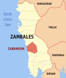
Basisdaten Bezirk: Central Luzon Provinz: Zambales Barangays: 23 Distrikt: 2. Distrikt von Zambales PSGC: 037102000 Einkommensklasse: 4. Einkommensklasse Haushalte: 4032 Zensus 1. Mai 2000Einwohnerzahl: 21.519 Zensus 1. August 2007Koordinaten: 15° 8′ N, 120° 9′ O15.133333333333120.15Koordinaten: 15° 8′ N, 120° 9′ O Postleitzahl: 2203 Geographische Lage auf den Philippinen 

Cabangan Cabangan ist eine philippinische Stadtgemeinde in der Provinz Zambales. Nach dem Zensus vom 1. Mai 2000 hat sie 18.848 Einwohner in 4032 Haushalten.
Baranggays
Cabangan ist politisch in 23 Baranggays unterteilt.
- Anonang
- Apo-apo
- Arew
- Banuambayo (Pob.)
- Cadmang-Reserva
- Camiling (Camiing)
- Casabaan
- Del Carmen (Pob.)
- Dolores (Pob.)
- Felmida-Diaz
- Laoag
- Lomboy
- Longos
- Mabanglit
- New San Juan
- San Antonio
- San Isidro
- San Miguel
- San Juan (Pob.)
- San Rafael
- Santa Rita
- Santo Niño
- Tondo
Städte und Stadtgemeinden in der Provinz ZambalesStädte: Olongapo City
Stadtgemeinden: Botolan | Cabangan | Candelaria | Castillejos | Iba | Masinloc | Palauig | San Antonio | San Felipe | San Marcelino | San Narciso | Santa Cruz | Subic
Wikimedia Foundation.
Schlagen Sie auch in anderen Wörterbüchern nach:
Cabangan — Original name in latin Cabangan Name in other language Cabangan State code PH Continent/City Asia/Manila longitude 15.158 latitude 120.0569 altitude 14 Population 3092 Date 2011 07 31 … Cities with a population over 1000 database
Cabangan, Zambales — Infobox Philippine municipality infoboxtitle = Municipality of Cabangan sealfile = locatormapfile = Ph locator zambales cabangan.png caption = Map of Zambales showing the location of Cabangan. region = Central Luzon (Region III) province =… … Wikipedia
Legazpi City — Infobox Philippine city infoboxtitle = City of Legazpi sealfile = Ph seal legazpicity.png locatormapfile = Ph locator albay legazpi.png caption = Map of Albay showing the location of Legazpi City region = Bicol Region (Region V) province = Albay… … Wikipedia
Tabaco City — For the narcotic, see tobacco. Infobox Philippine city infoboxtitle = City of Tabaco sealfile = locatormapfile = Ph locator albay tabaco.png caption = Map of Albay showing the location of Tabaco City. region = Bicol Region (Region V) province =… … Wikipedia
Mount Pinatubo — The eruption column of Mount Pinatubo on June 12, 1991, three days before the climactic eruption. Elevation … Wikipedia
Quezon, Isabela — Infobox Philippine municipality infoboxtitle = Municipality of Quezon sealfile = Quezon isabela.png locatormapfile = Ph locator isabela quezon.png| caption = Map of Isabela showing the location of Quezon. region = Cagayan Valley (Region II)… … Wikipedia
Masinloc, Zambales — Masinloc Municipality Map of Zambales showing the location of Masinloc … Wikipedia
San Felipe, Zambales — San Felipe Municipality Map of Zambales showing the location of San Felipe … Wikipedia
List of cities and municipalities in the Philippines — This is a list of cities and municipalities in the Philippines arranged by province and in alphabetical order. As of 2006, there are 118 cities and 1509 municipalities.As of September 4, 2007, there are 136 cities, 1,495 municipalities, 81… … Wikipedia
List of ZIP Codes in the Philippines — In the Philippines, the Philippine ZIP code is used by the Philippine Postal Corporation (Philpost) to simplify the distribution of mail. While in function it is similar to the ZIP code used in the United States, its form and its usage is quite… … Wikipedia
Cabangan


18+
© Academic, 2000-2026
- Kontaktieren Sie uns: Unterstützung, Werbung
Wörterbücher Export, schritte mit PHP, Joomla, Drupal, WordPress, MODx.