Barrenjoey Headland

Barrenjoey Headland
Barronjoey Headland
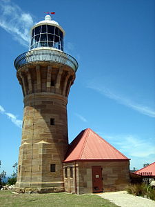
Barronjoey Headland Lighthouse
Gewässer 1 Pittwater
Gewässer 2 Hawkesbury River

Geographische Lage

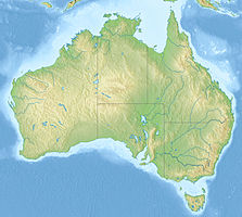
33° 34′ 49,99″ S, 151° 19′ 43,28″ O-33.580553151.328688Koordinaten: 33° 34′ 49,99″ S, 151° 19′ 43,28″ O
Barronjoey Headland (Australien)
Barronjoey Headland

Barrenjoey Headland ist eine Halbinsel, die den Ria Pittwater am südlichen Ende abschließt, und ist seit 1998 ein Teil des Ku-ring-gai-Chase-Nationalparks. Die Halbinsel ist durch einen Dünenstreifen, genannt Tombolo, mit dem Festland verbunden und ist ein Bestandteil des Vororts Palm Beach von Sydney in New South Wales, Australien. Die Halbinsel besteht aus Hawkesbury-Sandstein, der den Schiefer der Narrabeen Group überlagert.

Barronjeoy Headland von West Head aus betrachtet

Geschichte

Barrenjeoy entstand als Insel vor etwa 18.000 Jahren als eine Eiszeit zu Ende ging und die Flusstäler dieses Gebiets geflutet wurden. Die entstandene Insel wurde vermutlich später wieder mit dem Festland verbunden.

Am 2. März 1788 benannte der erste Gouverneur der Sträflingskolonie Australien Arthur Phillip auf einer Erkundungsfahrt die Halbinsel "Barrenjuee" (was kleines Känguru oder Wallaby bedeutet). Der Name wurde in Verlauf der Zeit unterschiedlich ausgesprochen und erst seit 1966 ist der Namen Barrenjoey allgemein anerkannt.[1]

Auf der Insel befindet sich das Barrenjoey Head Lighthouse, das aus Hawkesbury-Sandstein 1881 erbaut wurde. Das heutige Barrenjoey Head Lighthouse ist ein Leuchtturm mit Leuchtturmwärterhaus, die von dem Kolonialarchitekten James Barnet auf der Halbinsel gebaut wurden. Eine Zollstation wurde im Jahr auf Barrenjoey Headland 1843 errichtet um den Handel Richtung Sydneys vor Schmuggeleien von Rum zu kontrollieren; sie wurde 1903 geschlossen.[1]

Tourismus

Die Insel wird häufig von einem Parkplatz bei Palm Beech aus erwandert und bietet Ausblicke auf die Küstenlandschaft und auf die Broken Bay.

Einzelnachweise

  1. a b Barrenjoey Head Lighthouse at Palm Beach auf www.lighthouse.net.au

Wikimedia Foundation.

Игры ⚽ Поможем написать курсовую

Schlagen Sie auch in anderen Wörterbüchern nach:

  • Barrenjoey, New South Wales — reconnected the island to the mainland.HistoryOn the 2nd March 1788 Arthur Phillip named the headland Barrenjuee (meaning little kangaroo or wallaby). The areas name has had differently spelling throughout history, Barrenjoey now being the… …   Wikipedia

  • Palm Beach, New South Wales — Infobox Australian Place | type = suburb name = Palm Beach city = Sydney state = nsw caption = A view of Palm Beach from Barrenjoey Lighthouse lga = Pittwater Council postcode = 2108 est = 1911 pop = 1,601 (2001 census) [Census 2001… …   Wikipedia

  • Ku-ring-gai-Chase-Nationalpark — West Head Lookout …   Deutsch Wikipedia

  • Ku-ring-gai Chase National Park — Infobox protected area | name = iucn category = II caption = Map of Australia locator x = 255 locator y = 170 location = New South Wales nearest city = Sydney lat degrees = 33 lat minutes = 39 lat seconds = 3.6 lat direction = S long degrees =… …   Wikipedia

  • Pittwater Council — Infobox Australian Place | type = lga name = Pittwater Council state = nsw caption = pop = 56,829 density = 530 area = 91 est = seat = Mona Vale mayor = Cr David James JP region = Metropolitan Sydney url = http://www.pittwater.nsw.gov.au/… …   Wikipedia

  • Tombolo — A tombolo is a deposition landform such as a spit or bar which is attached to the mainland by a narrow piece of land. They usually form because the island causes wave refraction, depositing sand and shingle moved by longshore drift in each… …   Wikipedia

  • Tombolo — auf den Shetlandinseln …   Deutsch Wikipedia

  • Bilgola, New South Wales — Infobox Australian Place | type = suburb name = Bilgola city = Sydney state = NSW caption = lga = Pittwater Council postcode = est = pop = area = propval = stategov = Pittwater fedgov = Mackellar near nw = Avalon near n = Avalon near ne = near w …   Wikipedia

  • Coasters Retreat, New South Wales — Coasters Retreat Sydney, New South Wales Postcode …   Wikipedia

  • Tied island — View from the Isle of Portland looking towards the mainland of Great Britain. Chesil Beach on the left connects the tied island to the mainland …   Wikipedia

Share the article and excerpts

Direct link
Do a right-click on the link above
and select “Copy Link”