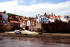
- Robin Hood’s Bay
-
Robin Hood’s Bay Koordinaten 54° 26′ N, 0° 32′ W54.4345-0.53440000000001Koordinaten: 54° 26′ N, 0° 32′ W Verwaltung Post town WHITBY Postleitzahlenabschnitt YO22 Vorwahl 01947 Landesteil England Region Yorkshire and the Humber Shire county North Yorkshire District Scarborough Britisches Parlament Scarborough and Whitby Website: robin-hoods-bay.co.uk Robin Hood’s Bay (deutsch: Robin Hoods Bucht) ist ein kleiner Fischerort an der britischen Nordseeküste im Süden der Stadt Whitby. Der einheimische und traditionelle Name des Dorfes ist Bay Town, und es ist ungewiss, ob Robin Hood jemals in diesem Ort war.
Das Wine-Haven-Profil von Robin Hood’s Bay ist der Global Boundary Stratotype Section and Point (GSSP: entspricht etwa einem Typprofil) des Pliensbachium, der Zeit von 189,6 bis 183 Millionen Jahre v. Chr., einer der vier chronographischen Unterstufen des unteren Jura.[1]
Literatur
- M. K. Howart: The Lower Lias of Robin Hood's Bay, Yorkshire, and the work of Leslie Bairstow. In: Bulletin of The Natural History Museum. Geology Series 58/2002, S. 81–152 Cambridge University Press, The Natural History Museum, 2002, doi: 10.1017/S0968046202000037 (Abstract)
Weblinks
Einzelnachweise
- ↑ GSSP for the Sinemurian-Pliensbachian Boundary, www.stratigraphy.org
Wikimedia Foundation.


