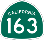
California State Route 163
- California State Route 163
-
California State Route 163 ist ein Highway im US-Bundesstaat Kalifornien, der in Nord-Süd-Richtung verläuft.
Der Highway beginnt an der Ash Street in San Diego und endet an der Interstate 15. Die State Route trägt auch den Namen Cabrillo Freeway und geht auf den Entdecker Juan Rodríguez Cabrillo zurück. Die State Route bildete bis 1979 das südliche Ende des U.S. Highways 395. Die ersten vier Kilometer verläuft sie durch den Balboa Park und unterquert dabei die Cabrillo Bridge.
Siehe auch
Weblink
Wikimedia Foundation.
Schlagen Sie auch in anderen Wörterbüchern nach:
California State Route 163 — Infobox road state=CA type=SR route=163 section=463 maint=Caltrans alternate name=Cabrillo Freeway length mi=11 length round=0 length ref= [http://www.dot.ca.gov/hq/structur/strmaint/brlog2.htm January 1, 2006 California Log of Bridges on State… … Wikipedia
California State Route 52 — Karte … Deutsch Wikipedia
California State Route 103 — Infobox road state=CA type=SR route=103 alternate name=Terminal Island Freeway section=403 maint=Caltrans length mi=1.60 length ref= [http://www.dot.ca.gov/hq/structur/strmaint/brlog2.htm January 1, 2006 California Log of Bridges on State… … Wikipedia
Nevada State Route 163 — State Route 163 Laughlin Highway Route information Maintained by NDOT Length … Wikipedia
California State Route 238 — State Route 238 Mission Boulevard, Foothill Boulevard … Wikipedia
California State Route 20 — Infobox road state=CA type=SR route=20 section=320 maint=Caltrans history=State highway in 1910 19; numbered in 1934 length mi=211.882 length round=3 length ref= length notes=(plus about 15.5 mi (25 km) on US 101) direction a=West terminus… … Wikipedia
California State Route 19 — Infobox road state=CA type=SR route=19 section=319 and 464 maint=Caltrans alternate name=Lakewood Boulevard, Rosemead Boulevard length mi=26.2 length ref= [California Department of Transportation, [http://web.archive.org/web/20040306063946/http://… … Wikipedia
California State Route 52 — Infobox road state=CA type=SR route=52 section=352 maint=Caltrans length mi=15 length round=0 length ref=Fact|date=January 2008 established= direction a=West terminus a=jct|state=CA|I|5 in San Diego direction b=East terminus b=jct|state=CA|SR|125 … Wikipedia
California State Route 15 — Infobox road state=CA type=SR route=15 alternate name=Escondido Freeway section=315 maint=Caltrans length mi=5.59 length ref= [http://www.dot.ca.gov/hq/structur/strmaint/brlog2.htm January 1, 2006 California Log of Bridges on State Highways] ]… … Wikipedia
California State Route 162 — Infobox road state=CA type=SR route=162 section=462 maint=Caltrans length mi= length round= length ref=fact established= direction a=West terminus a=jct|state=CA|US|101 at Longvale junction=jct|state=CA|FH|7|nolink1=yes near Covelo… … Wikipedia
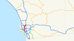
 I-15 in San Diego
