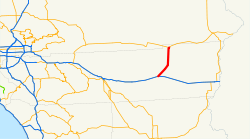
California State Route 177
Schlagen Sie auch in anderen Wörterbüchern nach:
California State Route 177 — Infobox road state=CA type=SR route=177 alternate name=Desert Center Rice Road section=477 maint= length mi=27.024 length round=3 length ref= direction a=South terminus a=jct|state=CA|I|10 near Desert Center direction b=North terminus b=jct|state … Wikipedia
California State Route 62 — Infobox road state=CA type=SR route=62 alternate name=Twentynine Palms Highway, Desert Center Rice Road section=362 maint= length mi=151.438 length round=3 length ref= direction a=West terminus a=jct|state=CA|I|10 near White Water… … Wikipedia
California State Route 60 — State Route 60 Route information … Wikipedia
California State Route 85 — State Route 85 West Valley Freeway … Wikipedia
California State Route 55 — State Route 55 Route information … Wikipedia
California State Route 180 — Infobox road state=CA type=SR route=180 alternate name=Sequoia Kings Canyon Freeway, Kings Canyon Road section=480 maint=Caltrans length mi=112.31 length ref= [http://www.dot.ca.gov/hq/structur/strmaint/brlog2.htm January 1, 2006 California Log… … Wikipedia
California State Route 178 — Infobox road state=CA type=SR route=178 section=478 maint=Caltrans length mi=166.81 length round=0 length ref=cite web|url=http://www.dot.ca.gov/hq/structur/strmaint/brlog2.htm|title=California Log of Bridges on State… … Wikipedia
California State Route 183 — Infobox road state=CA type=SR route=183 section=483 maint=Caltrans length mi=10 length round=0 length ref= [ [http://www.dot.ca.gov/hq/structur/strmaint/brlog2.htm January 1, 2006 California Log of Bridges on State Highways] ] direction a=South… … Wikipedia
California State Route 175 — Infobox road state=CA type=SR route=175 section=475 maint=Caltrans length mi=37.89 length round=2 length ref= [http://www.dot.ca.gov/hq/structur/strmaint/brlog2.htm January 1, 2006 California Log of Bridges on State Highways] ] direction a=West… … Wikipedia
California State Route 182 — Infobox road state=CA type=SR route=182 section=482 maint=Caltrans length mi=12.65 length round=2 length ref= [ [http://www.dot.ca.gov/hq/structur/strmaint/brlog2.htm January 1, 2006 California Log of Bridges on State Highways] ] direction… … Wikipedia


 I-10 in Desert Center
 CA 62 nahe Rice
 I-10
I-10


 CA 62
CA 62