California State Route 209
Schlagen Sie auch in anderen Wörterbüchern nach:
California State Route 209 — Infobox road state=CA type=CA route=209 length mi=8 length round=0 length ref= history=State highway in 1933; numbered in 1964; deleted in 2003 direction a=South terminus a=Cabrillo National Monument direction b=North terminus… … Wikipedia
California State Route 99 — Infobox road state=CA type=SR route=99 section=399 maint=Caltrans length mi=424.85 length ref= [http://www.dot.ca.gov/hq/structur/strmaint/brlog2.htm January 1, 2006 California Log of Bridges on State Highways] ] length round=2 length… … Wikipedia
California State Route 211 — Infobox road state=CA type=SR route=211 section=511 alternate name=Main Street, Fernbridge Drive maint=Caltrans length mi=5.395 length round=3 length ref= direction a=South terminus a=Ocean Avenue in Ferndale direction b=North terminus… … Wikipedia
Washington State Route 20 — State Route 20 Whidbey Scenic Isle Way North Cascades Highway … Wikipedia
New York State Route 52 — This article is about the current alignment of NY 52. For the former alignment of NY 52 in the Finger Lakes region, see New York State Route 52 (1920s–1930). NYS Route 52 … Wikipedia
State Scenic Highway System (California) — infobox road state=CA marker highway name=State Scenic Highway SystemThe State Scenic Highway System is a list of highways, mainly state highways, that have been designated by the California Department of Transportation (Caltrans) as scenic… … Wikipedia
List of highways numbered 209 — The following highways are numbered 209: Canada Nova Scotia Route 209 Quebec Route 209 Saskatchewan Highway 209 India National Highway 209 (India) United States U.S. Route 209 … Wikipedia
Liste der State-, U.S.- und Interstate-Highways in Kalifornien — Dies ist eine Aufstellung von State Highways in Kalifornien, USA nach Nummern. Inhaltsverzeichnis 1 State Routes 2 Interstates 2.1 Zubringer und Umgehungen 3 U.S. Highways … Deutsch Wikipedia
State highways in Colorado — The standard Colorado state highway sign. The top half is the flag of Colorado. Highway names Interstates: Interstate X (I X) US Routes: U.S. Highway X (US X) … Wikipedia
Deleted state highways in California — Standard route signage in California … Wikipedia
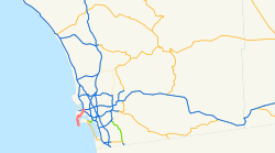
 I-5
I-5  I-8 in San Diego
