- Brathay
-
Brathay 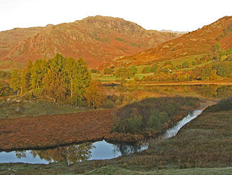
Der Brathay bei seinem Ausfluss aus dem Little Langdale Tarn
Daten Lage Lake District, Cumbria, England Flusssystem Leven (Cumbria) Quelle auf dem Wrynose Pass
54° 24′ 56″ N, 3° 6′ 36″ W54.41548-3.11393Quellhöhe 393 m Mündung Zusammenfluss mit dem Rothay 54.42324-2.972453Koordinaten: 54° 25′ 24″ N, 2° 58′ 21″ W
54° 25′ 24″ N, 2° 58′ 21″ W54.42324-2.972453Durchflossene Seen Little Langdale Tarn, Elter Water Der Brathay ist ein Fluss im Lake District, Cumbria in England. Der Brathay hat seinen Ursprung auf dem Wrynose Pass unweit des Three Shire Stone.
Der Brathay folgt der Straße über den Wrynose Pass in Richtung Osten. Er fließt erst durch den Little Langdale Tarn und dann durch den Elter Water See.
Südwestlich von Ambleside mündet der Brathay in den Rothay.
Der Fluss war in seiner gesamten Länge ein Teil der historischen Grenze zwischen Lancashire und Westmorland, heute liegt er Fluss vollständig in Cumbria.
Kategorien:- Flusssystem Leven (Cumbria)
- Fluss in Europa
- Fluss in England
- Cumbria

Wikimedia Foundation.