- River Rothay
-
Rothay 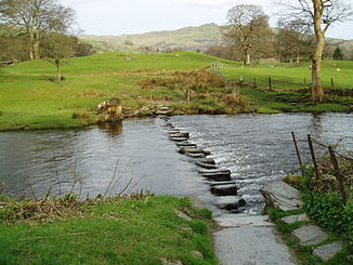
Trittsteine im Rothay bei Rydal
Daten Lage Cumbria, England Flusssystem Leven Flussgebietseinheit North West Ursprung oberhalb von Dunmail Raise
54° 29′ 16″ N, 3° 4′ 22″ W54.48777-3.0728470Quellhöhe 470 m Mündung in den Windermere See 54.19529-2.968726Koordinaten: 54° 11′ 43″ N, 2° 58′ 7″ W
54° 11′ 43″ N, 2° 58′ 7″ W54.19529-2.968726Linke Nebenflüsse Brathay Durchflossene Seen Grasmere, Rydal Water Kleinstädte Grasmere, Ambleside Der River Rothay ist ein kleiner Fluss im Lake District in Cumbria, England.
Der Rothay entspringt in 470 m Höhe (OS Grid Reference NY306108) oberhalb von Dunmail Raise. Das Einzugsgebiet des Rothay sind Grasmere Common und Easedale Tarn, die Südseite von Fairfield und verschiedene Berge östlich von Dunmail Raise u.a. Great Rigg, Rydal Fell, Scandale Fell und Heron Pike.
Nördlich des Ortes Grasmere fließen der Easedale Gill und der Sour Milk Gill in den Rothay. Der Fluss durchquert dann den Ort Grasmere und fließt dann durch den Grasmere See. Der Fluss verlässt den See am Südende und nach 800 m geht er in den Rydal Water See an dessen westlichen Ende über. Der Rothay verlässt den Rydal Water See in dessen Süd-Osten und fließt in der Richtung von Ambleside. Südwestlich des Ortes Ambleside fließt der Brathay in den Rothay bevor dieser in den Windermere See übergeht.
Der Rothay ist besonders zwischen Grasmere und Rydal mit Schwierigkeiten von II bis III bei Kajakfahrern beliebt. Forellen leben im Rothay.

Wikimedia Foundation.