- Catanduanes
-
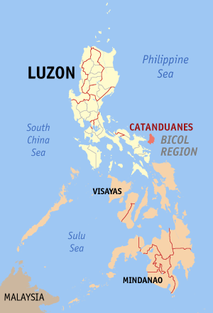
 Lage der Provinz Catanduanes
Catanduanes (Filipino: Katandwanes) ist eine Inselprovinz im Osten der Philippinen mit der Hauptstadt Virac.
Sie hat 232.757 Einwohner (2007) und eine Fläche von 1.492,16 km².
Die Insel liegt östlich der philippinischen Hauptinsel Luzon. Im Westen grenzt sie an den Maquela-Kanal, im Südwesten an den Golf von Lagonoy, im Norden und Osten an die Philippinensee.
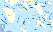 Karte mit den mittleren Philippinen und der Insel Catanduanes ganz im Nordosten
Sie wird zur Luzon-Inselgruppe gerechnet und gehört zum Regierungsbezirk Bicol.
Das tropische Klima kennt Anfang des Jahres regenreichen Monsun und zur Jahresmitte trockene Monsunwinde. Im Zentrum der Insel liegt das 427,78 km² große Catanduanes Watershed Forest Reserve.
Geschichte
1573 erreichten die Spanier mit Juan de Salcedo die Insel, sie waren auf der Jagd nach Piraten und unterwarfen die Einwohner.
Ab 1600 wirkten katholische Missionare auf der Insel. Nach der Annexion der Philippinen durch die Amerikaner kam es auf der Insel in den 1930er Jahren zu Aufständen gegen die neuen Herrscher. Im 2. Weltkrieg besetzten die Japaner 1942 mit den Philippinen auch die Catanduanes. Es entstand ein regionaler Widerstand, dem es nach jahrelangen Kämpfen im Februar 1945 gelang, die japanischen Besatzer zu überwinden.
Mit Inkrafttreten des Commonwealth Act No. 687 am 16. Oktober 1945 wurde Catanduanes von der Provinz Albay unabhängig und bildet seitdem mit einigen weiteren, aber sehr kleinen Inseln eine eigene Provinz.
Weblinks
Ilocos-Region: Ilocos Norte | Ilocos Sur | La Union | Pangasinán
Cagayan Valley: Batanes | Cagayan | Isabela | Nueva Vizcaya | Quirino
Central Luzon: Aurora | Bataan | Bulacan | Nueva Ecija | Pampanga | Tarlac | Zambales
CALABARZON: Batangas | Cavite | Laguna | Quezon | Rizal
MIMAROPA: Marinduque | Occidental Mindoro | Oriental Mindoro | Romblon
Bicol-Region: Albay | Camarines Norte | Camarines Sur | Catanduanes | Masbate | Sorsogon
Regierungsbezirk Cordillera: Abra | Apayao | Benguet | Ifugao | Kalinga | Mountain Province
Metro Manila: keine Provinzen
Wikimedia Foundation.
Schlagen Sie auch in anderen Wörterbüchern nach:
Catanduanes — Saltar a navegación, búsqueda Provincia de Catanduanes … Wikipedia Español
Catanduānes — Catanduānes, Insel, südöstlich von der Philippinen Insel Manila (SOAsien), gehört zur Provinz Camerines, 16 QM., sehr fruchtbar, Schiffsbau; die Einwohner sind gute Seeleute … Pierer's Universal-Lexikon
Catanduanes — Infobox Philippine province name = Catanduanes sealfile = Ph seal catanduanes.png region = Bicol Region (Region V) capital = Virac founded = September 26, 1945 pop2000 = 215,356 pop2000rank = 13th smallest popden2000 = 142 popden2000rank = 24th… … Wikipedia
Catanduanes — 13° 50′ 00″ N 124° 15′ 00″ E / 13.8333, 124.25 … Wikipédia en Français
Catanduanes — ▪ island, Philippines island, east central Philippines, in the Philippine Sea, separated from southeastern Luzon (Rungus Point) by the shallow Maqueda Channel. Farming is diversified (rice, corn [maize], copra, abaca) on the hilly, rolling… … Universalium
Catanduanes State Colleges — Infobox University name = Catanduanes State Colleges motto = established = 1971 type = Public, State College president = Asuncion V. Asetre, Ph.D. head label = city = Virac state = Catanduanes country = Philippines undergrad = postgrad = staff=… … Wikipedia
Catanduanes (island) — Infobox Islands name = Catanduanes image caption = locator native name = native name link = location = South East Asia coordinates =coord|13|48|N|124|16|E|region:PH type:isle archipelago = Philippine Islands area = 1,511.50 km² rank = highest… … Wikipedia
Catanduanes Watershed Forest Reserve — 13.866666666667124.18333333333 Koordinaten: 13° 52′ N, 124° 11′ O … Deutsch Wikipedia
Catanduanes — Catanduạnes, gebirgige Insel und Provinz (mit Nebeninseln) vor der Südostküste von Luzon, Philippinen, 1 511 km2, 175 200 Einwohner; Reis , Kokospalmen , Manilahanfanbau.Von der Hauptstadt Virac (40 100 Einwohner) Fluglinien nach Manila und… … Universal-Lexikon
Virac, Catanduanes — Virac is a 2nd class municipality in the province of Catanduanes, Philippines. It is the third largest town and the capital municipality of Catanduanes. It has a land area of 188 km². According to the 2000 census, it has a population of 57,067… … Wikipedia
- Kontaktieren Sie uns: Unterstützung, Werbung
Catanduanes

18+
© Academic, 2000-2026
Wörterbücher Export, schritte mit PHP, Joomla, Drupal, WordPress, MODx.