Columbia Mountains

Columbia Mountains

f1

Columbia Mountains
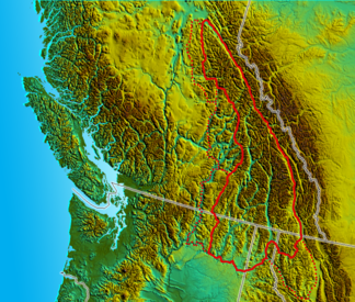
Umriss der Columbia Mountains in Kanada und den USA

Umriss der Columbia Mountains in Kanada und den USA

Höchster Gipfel Mount Sir Sandford (3.519 m)
Lage British Columbia, Kanada; Montana, Idaho, Washington, USA
Koordinaten 52° N, 118° W51.656666666667-117.86753519Koordinaten: 52° N, 118° W
Fläche 135.952 km²

Die Columbia Mountains sind eine Gruppe von Bergketten im Südosten von British Columbia, und teilweise in Montana, Idaho, Washington. Sie erstrecken sich über eine Fläche von 135.952 km². Drei Viertel des Gebirges liegt in Kanada und das restliche Viertel in den Vereinigten Staaten. Das Gebirge wird durch den Grabenbruch Rocky Mountain Trench im Osten und die Kootenay River im Süden begrenzt, die westliche Grenze ist der Rand des Interior Plateau. Der Berg Mount Sir Sandford ist der höchste im Gebirge, er erreicht 3519 Meter.

Die Columbia Mountains werden in die Bergketten der Cariboo, Monashee, Selkirk und Purcell Mountains unterteilt. In den Columbia Mountains entspringen die Quellflüsse des Columbia Rivers.

Bilder

Weblinks

 Commons: Columbia Mountains – Sammlung von Bildern, Videos und Audiodateien

Wikimedia Foundation.

Игры ⚽ Поможем написать курсовую

Schlagen Sie auch in anderen Wörterbüchern nach:

  • Columbia Mountains —   [kə lʌmbɪə maʊntɪnz], Gebirgsgruppe der kanadischen Kordilleren im Süden der Provinz British Columbia, besteht aus verschiedenen Ketten (Monashee Mountains, Selkirk Mountains, Purcell Mountains, Cariboo Mountains), die durch Gräben getrennt… …   Universal-Lexikon

  • Columbia Mountains — For the mountain range in Antarctica, see Columbia Mountains (Antarctica). Columbia Mountains Range Mount Sir Sandford from the Got …   Wikipedia

  • Columbia Mountains — ▪ mountain range, Canada       range in southeastern British Columbia, Canada, that is bounded by the Rocky Mountain Trench (east), the Columbia River (south), the Interior Plateau (west), and the Fraser River (north). The Columbia Mountains… …   Universalium

  • Columbia Mountains — Sp Kolùmbijos kalna Ap Columbia Mountains L Uolinių kk. dalis, Kanada (Alberta, Britų Kolumbija) …   Pasaulio vietovardžiai. Internetinė duomenų bazė

  • Columbia Mountains (Antarctica) — Coordinates: 70°14′S 63°51′W / 70.233°S 63.85°W / 70.233; 63.85 The Columbia Mountains are a group of largely b …   Wikipedia

  • Columbia River — Der Columbia RiverVorlage:Infobox Fluss/KARTE fehlt Daten …   Deutsch Wikipedia

  • Columbia River — Coordinates: 46°14′39″N 124°3′29″W / 46.24417°N 124.05806°W / 46.24417; 124.05806 …   Wikipedia

  • Columbia River Basalt Group — The Columbia River Basalt Group (including the Steen and Picture Gorge basalts) extends over portions of five states. The Columbia River Basalt Group is a large igneous province that lies across parts of the Western United States . It is found in …   Wikipedia

  • Columbia River Gorge — For the Washington Oregon wine region, see Columbia Gorge AVA. Columbia River Gorge Protected Area L …   Wikipedia

  • Columbia River Treaty — The Duncan Dam was required under the Treaty, and was completed in 1967. It has no powerhouse and remains purely a storage project …   Wikipedia

Share the article and excerpts

Direct link
Do a right-click on the link above
and select “Copy Link”