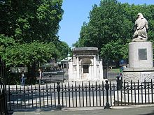
Coram’s Fields

Coram’s Fields
Das Haupttor von Coram’s Fields
Hinweistafel, die Besucher auf das Zugangsverbot für Erwachsene aufmerksam macht

Coram’s Fields, offizielle Langform: Coram’s Fields and the Harmsworth Memorial Playground,[1] sind eine rund 2,8 Hektar große Parkanlage im Londoner Stadtbezirk Camden. Der nach dem Geschäftsmann und Philanthropen Thomas Coram benannte Park liegt etwa 500 Meter südöstlich der beiden Bahnhöfe King’s Cross und St Pancras. Im Park befinden sich neben verschiedenen Sportanlagen und Spielplätzen ein Jugendzentrum, ein Kindergarten und ein Tiergehege.

Coram’s Fields befinden sich am ehemaligen Standort des 1739 von Coram gegründeten Kinderheimes Foundling Hospital. 1926 wurde das Heim in die etwa 30 Kilometer südlich gelegene Kleinstadt Redhill verlegt; das Gelände wurde in der Folge verkauft und das Gebäude abgetragen. Der Plan des neuen Eigentümers, den Obst-, Gemüse- und Blumenmarkt von Covent Garden nach Camden zu übersiedeln, scheiterte an lokalem Widerstand. 1936 schließlich erwarb eine Interessengruppe unter finanzieller Führung von Harold Harmsworth das Grundstück und wandelte es in einen Kinderspielplatz um.[2]

Auch heute ist der Park ausschließlich zur Nutzung durch Kinder und Jugendliche freigegeben. Erwachsene dürfen Coram’s Fields nur in Begleitung eines Kindes oder Jugendlichen unter 16 Jahren betreten.

1987 wurden Coram’s Fields zusammen mit den angrenzenden öffentlichen Gärten Brunswick Square und Mecklenburgh Square in die britische Denkmalliste aufgenommen, wo sie als „von nationaler Bedeutung und speziellem Interesse“ (Grade II) eingestuft sind.[3] Der Park wird heute von einem unabhängigen Wohlfahrtsverband verwaltet; pro Jahr nutzen ihn mehr als 150.000 Besucher.[4]

Die nächstgelegene Station der London Underground ist Russell Square.

Weblinks

 Commons: Coram’s Fields – Sammlung von Bildern, Videos und Audiodateien

Einzelnachweise

  1. Coram’s Fields and the Harmsworth Memorial Playground. Charity Commission for England and Wales. Abgerufen am 14. Mai 2011.
  2. Rhian Harris: The Foundling Hospital. BBC History. Abgerufen am 14. Mai 2011.
  3. Coram’s Fields, with Mecklenburgh and Brunswick Squares. Datenbank der National Heritage List for England. Abgerufen am 14. Mai 2011.
  4. Coram’s Fields and the Harmworth Memorial Playground – Summary Information Return 2010. Charity Commission for England and Wales. Abgerufen am 15. Mai 2011. (PDF-Datei, 13 KB)
51.525-0.12039999999999

Wikimedia Foundation.

Игры ⚽ Нужно сделать НИР?

Schlagen Sie auch in anderen Wörterbüchern nach:

  • Coram's Fields — Coordinates: 51°31′29″N 0°07′11″W / 51.5247°N 0.1197°W / 51.5247; 0.1197 …   Wikipedia

  • Coram — may refer to: Coram, working name of the Thomas Coram Foundation for Children, an English charity Coram Boy, a novel by Jamila Gavin Coram Boy (play), a stage play adopted from the novel by Jamila Gavin Coram, Montana, place in Flathead County… …   Wikipedia

  • Thomas Coram — Thomas Coram, Gemälde von William Hogarth, 1740 Thomas Coram (* 1668 in Lyme Regis, Dorset, Vereinigtes Königreich; † 29. März 1751 in London) war ein britischer Geschäftsmann und Philanthrop. Coram fuhr schon als zwölfjähriger zur See und wurde… …   Deutsch Wikipedia

  • Thomas Coram — Infobox Person name = Thomas Coram image size = 200px caption = Thomas Coram painted by William Hogarth, 1740 birth date = (c. 1668) birth place = Lyme Regis, Dorset, United Kingdom death date = March 29, 1751 death place = education = occupation …   Wikipedia

  • Bloomsbury — infobox UK place country = England map type = Greater London region= London population= official name= Bloomsbury latitude= 51.5262 longitude= 0.1178 os grid reference= TQ305825 london borough= post town= LONDON postcode area= WC postcode… …   Wikipedia

  • Foundling Hospital — The Foundling Hospital in London, England was founded in 1739 by the philanthropic sea captain Thomas Coram. It was a children s home established for the education and maintenance of exposed and deserted young children. The word hospital was used …   Wikipedia

  • Mecklenburgh Square — Coordinates: 51°31′28″N 0°7′7″W / 51.52444°N 0.11861°W / 51.52444; 0.11861 …   Wikipedia

  • St Pancras New Church — For the saint after whom this church is named, see Pancras of Rome. There is a list of other places named after him at St Pancras. St Pancras New Church St Pancras New Church Present Day Country …   Wikipedia

  • Camden — /kam deuhn/, n. 1. a borough of Greater London, England. 192,800. 2. a port in SW New Jersey, on the Delaware River opposite Philadelphia. 84,910. 3. a city in SW Arkansas. 15,356. * * * ▪ Arkansas, United States       city, seat (1843) of… …   Universalium

  • Brunswick Square — is a public garden in Bloomsbury, in the London Borough of Camden. It is overlooked by the School of Pharmacy and the Foundling Museum to the north and the Brunswick Centre to the west. South of it lies International Hall (a hall of residence of… …   Wikipedia

Share the article and excerpts

Direct link
Do a right-click on the link above
and select “Copy Link”