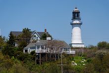
Two Lights State Park

Two Lights State Park
Leuchtturm von Two Lights

Der Two Lights State Park ist ein State Park im Cumberland County im US-Bundesstaat Maine. Der 16 Hektar große Park liegt an der Felsküste Maines östlich der Stadt Portland an der Casco Bay nahe Cape Elizabeth.

Inhaltsverzeichnis

Geschichte

The Lighthouse at Two Lights
Edward Hopper, 1929
Öl auf Leinwand, 74,9 cm × 109,9 cm
Metropolitan Museum of Art, New York City

Link zum Bild
(Bitte Urheberrechte beachten)

Der State Park wurde 1961 gegründet. Der Name des Parks stammt von den zwei Leuchtfeuern, die 1828 errichtet wurden. Das östliche Leuchtfeuer ist noch aktiv und wird Cape Elizabeth Lighthouse genannt. 1963 wurde das Leuchtfeuer automatisiert, 1974 wurde der Leuchtturm in das National Register of Historic Places eingetragen. Das westliche Leuchtfeuer wurde 1924 außer Dienst gestellt und befindet sich heute in Privatbesitz. Cape Elizabeth Light diente Edward Hopper als Motiv für mehrere Aquarelle und Gemälde, unter anderem für sein 1929 entstandenes Bild The Lighthouse at Two Lights. Während des Zweiten Weltkriegs wurde an der Bucht eine Küstenbatterie angelegt. Bunker und ein Beobachtungsturm aus Beton sind noch erhalten, aber nicht zugänglich.

Touristische Einrichtungen

Der Besuch des Parks ist gebührenpflichtig. Der Park verfügt über einen Picknickbereich mit Aussicht über die Casco Bay. Etwa ein Kilometer südlich liegt der 98 Hektar große Crescent Beach State Park, der 1966 an einem etwa 1,5 Kilometer langen, halbmondförmigen Sandstrand eröffnet wurde. Der Strand dient für vielfältige Freizeit- und Wassersportaktivitäten, hinter dem Strand liegt ein bewaldeter Dünengürtel, durch den Spazierwege führen. Im Winter werden im Park Langlauf-Loipen gespurt.

Literatur

  • Barbara Sinotte: Maine: A Guide to the State Parks, National Parks & Historic sites. Kindle Edition 2010

Weblinks


43.5606405-70.20588

Wikimedia Foundation.

Игры ⚽ Нужен реферат?

Schlagen Sie auch in anderen Wörterbüchern nach:

  • Two Lights State Park — is a State Park located on Cape Elizabeth, Maine. It is a popular point of destination for Maine residents and the many visitors who enjoy the state s rocky coast. Opened in 1961, the park includes 41 acres of rocky headlands. Standing high above …   Wikipedia

  • Cherry Springs State Park — Coordinates: 41°39′46″N 77°49′23″W / 41.66278°N 77.82306°W / 41.66278; 77.82306 …   Wikipedia

  • Black Moshannon State Park — Geobox Protected Area name = Black Moshannon State Park native name = other name = other name1 = category local = Pennsylvania State Park category iucn = III image size = 300 image caption = View of bog and lake from the bog trail in the Black… …   Wikipedia

  • Onondaga Cave State Park — Coordinates: 38°3′40″N 91°13′38″W / 38.06111°N 91.22722°W / 38.06111; 91.22722 …   Wikipedia

  • Laurel Hill State Park — Geobox Protected Area name = Laurel Hill State Park native name = other name = other name1 = category local = Pennsylvania State Park category iucn = III image caption = etymology type = etymology = country = United States state = Pennsylvania… …   Wikipedia

  • Clear Creek State Park — For the Pennsylvania state forest, see Clear Creek State Forest. Clear Creek State Park Pennsylvania State Park Natural Monument (IUCN III) …   Wikipedia

  • Hills Creek State Park — Geobox Protected Area name = Hills Creek State Park native name = other name = other name1 = category local = Pennsylvania State Park category iucn = III image caption = A view of Hills Creek Lake from the main parking area near the park office.… …   Wikipedia

  • Ryerson Station State Park — Geobox Protected Area name = Ryerson Station State Park native name = other name = other name1 = category local = Pennsylvania State Park category iucn = III image caption = A stream passing through Ryerson Station State Park etymology type =… …   Wikipedia

  • Cobscook Bay State Park — is a state park, surrounded by the salt waters of Cobscook Bay, and located four miles (6 km) south of Dennysville, Maine. The park contains 888 acres (3.59 km2) of land and provides magnificent views of the ebb and flow of the tides.… …   Wikipedia

  • Mount Blue State Park — is a popular recreation, camping, and swimming area run by the state of Maine located in Franklin County. Its facilities are situated on the shores of Webb Lake in Weld, near mountains Mount Blue, Little Jackson, and Tumbledown Mountain. The… …   Wikipedia

Share the article and excerpts

Direct link
Do a right-click on the link above
and select “Copy Link”