Canyon Day

Canyon Day
Canyon Day
Gila County Incorporated and Unincorporated areas Canyon Day highlighted.svg
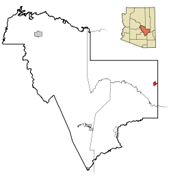
Lage im County und in Arizona
Basisdaten
Staat: Vereinigte Staaten
Bundesstaat: Arizona
County:

Gila County

Koordinaten: 33° 47′ N, 110° 1′ W33.787777777778-110.023611111111524Koordinaten: 33° 47′ N, 110° 1′ W
Zeitzone: Mountain Standard Time (UTC−7)
Einwohner: 1092 (Stand: 2000)
Bevölkerungsdichte: 110,3 Einwohner je km²
Fläche: 9,9 km² (ca. 4 mi²)
davon 9,9 km² (ca. 4 mi²) Land
Höhe: 1524 m
FIPS: 04-10040
GNIS-ID: 0002435

Canyon Day (Westliche Apachen: Yangongai) ist ein Census-designated place im Gila County im US-Bundesstaat Arizona. Sie liegt im Osten Arizonas an der Grenze zum Apache County und hat 1092 Einwohner auf 9,9 km². Nächster Flughafen ist der Whiteriver Airport in Whiteriver. Der Ort liegt in der Fort-Apache-Reservation. Die Bevölkerungsdichte liegt bei 110,3 je km². Der Ort liegt an der Arizona State Route 73.


Wikimedia Foundation.

Игры ⚽ Нужно решить контрольную?

Schlagen Sie auch in anderen Wörterbüchern nach:

  • Canyon Day — Canyon Day, AZ U.S. Census Designated Place in Arizona Population (2000): 1092 Housing Units (2000): 301 Land area (2000): 3.830832 sq. miles (9.921809 sq. km) Water area (2000): 0.000000 sq. miles (0.000000 sq. km) Total area (2000): 3.830832 sq …   StarDict's U.S. Gazetteer Places

  • Canyon Day, AZ — U.S. Census Designated Place in Arizona Population (2000): 1092 Housing Units (2000): 301 Land area (2000): 3.830832 sq. miles (9.921809 sq. km) Water area (2000): 0.000000 sq. miles (0.000000 sq. km) Total area (2000): 3.830832 sq. miles… …   StarDict's U.S. Gazetteer Places

  • Canyon Day — Original name in latin Canyon Day Name in other language State code US Continent/City America/Phoenix longitude 33.78477 latitude 110.02649 altitude 1527 Population 1209 Date 2011 05 14 …   Cities with a population over 1000 database

  • Canyon Day, Arizona — Infobox Settlement official name = Canyon Day, Arizona settlement type = CDP image caption = imagesize = image caption = imagesize = mapsize = 250px map caption = Location in Gila County and the state of Arizona mapsize1 = map caption1 =… …   Wikipedia

  • Canyon Diablo, Arizona — Canyon Diablo is a ghost town on the Navajo Reservation in Coconino County, Arizona, United States on the edge of the arroyo Canyon Diablo.The town which is about 12 miles northwest of Meteor Crater was the closest community to the crater when… …   Wikipedia

  • Canyon Creek Hotel Steamboat Springs (Steamboat Springs) — Canyon Creek Hotel Steamboat Springs country: United States, city: Steamboat Springs (Steamboat Springs) Canyon Creek Hotel Steamboat Springs Enjoying a picturesque location at the base of Mount Werner and five other peaks, the Canyon Creek Hotel …   International hotels

  • Canyon De Chelly National Monument — Carte du Canyon de Chelly Le Canyon de Chelly (prononcer «d chai») est un monument national américain situé dans l état de l Arizona, au sud ouest des États Unis. Le mot «Chelly » est une déformation anglaise du mot navajo «tseqi», qui… …   Wikipédia en Français

  • Canyon of Heroes — is a colloquialism referring to the section of New York City s lower Broadway and the Financial District that is the historic location of the city s ticker tape parades.The traditional route of the parade is northward from Bowling Green to City… …   Wikipedia

  • Day Valley, California — Day Valley   census designated place   …   Wikipedia

  • Day Fire — in the visible light spectrum as seen from space …   Wikipedia

Share the article and excerpts

Direct link
Do a right-click on the link above
and select “Copy Link”