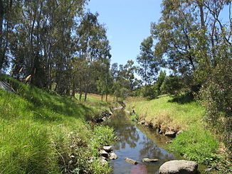
- Darebin Creek
-
Darebin Creek Darebin Creek in Heidelberg West
Daten Lage Victoria (Australien) Flusssystem Yarra River Abfluss über Yarra River → Port Phillip Bay → Bass-Straße Quelle bei Woodstock
37° 30′ 49″ S, 145° 1′ 10″ O-37.51356827145.01944439277Quellhöhe 277 m[1] Mündung Yarra River -37.783333333333145.0518.1Koordinaten: 37° 47′ 0″ S, 145° 3′ 0″ O
37° 47′ 0″ S, 145° 3′ 0″ O-37.783333333333145.0518.1Mündungshöhe 18,1 m[1] Höhenunterschied 258,9 m Länge 42,8 km[1] Kleinstädte South Morang, Epping, Lalor, Bundoora, Preston, Ivanhoe, Alphington Gemeinden Woodstock, Wollert Der Darebin Creek ist ein Bach im Süden des australischen Bundesstaates Victoria. Er durchfließt die nördlichen Vororte von Melbourne, entwässert das Darebin Valley und gehört zu den größeren Nebenflüssen des Yarra River. Zehntausende von Jahren lang diente er den Wurundjeri, einem Aborigines-Stamm der Kulin, die Woiwurrung sprachen, als Nahrungs- und Werkzeugquelle.
Der Bach entspringt im Norden des Stadtgebietes von Melbourne, nördlich von Epping, fließt ungefähr nach Süden und trifft bei Alphington auf den Yarra River. Er stellt auf weiten Strecken die Grenze zwischen den Local Government Areas von Darebin City und Banyule City dar. Früher trocknete der Darebin Creek im Sommer aus, aber der erhöhte Abfluss von Regenwasser an den immer mehr urbanisierten Ufern sorgt heute für eine permanente Wasserführung.
Der Bach verläuft durch die Darebin Parklands und den Rockbeare Park, ein großes Naturresevat 1–2 km nordwestlich der Mündung in den Yarra River. Am Unterlauf führt der Darebin Creek Trail, ein Wanderweg, an den Ufern entlang.
Inhaltsverzeichnis
Geographie
Die Quellen des Darebin Creek liegen in Wollert bei South Morang und sogar bis in Woodstock, von wo das Wasser ungefähr nach Süden bis Epping läuft.
Parks
Überreste von Melbournes früher Landwirtschaft kann man in den Darebin Parklands in Alphigton und Ivanhoe sehen. Die Olivenbäue und Obstbäume im Park sind mehr als 100 Jahre alt. Der Darebin Creek Trail verbindet viele der Parks, weil er dem Unterlauf des Baches fast auf seiner ganzen Länge folgt.
Folgende Parks liegen am Darebin Creek (stromaufwärts sortiert)[2]:
- Yarra Bend Park
- Darebin Parklands
- Dundas Street Wetlands
- Olympic Park
- Sullivan's Park
- LaTrobe Wildlife Reserve
- Bundoora Park
Weblinks
Einzelnachweise
- ↑ a b c Map of Darebin Creek, VIC. Bonzle.com
- ↑ Melway. Ausgabe 36 (2009)
Wikimedia Foundation.

