Dott Ice Rise

Dott Ice Rise
-79.275-81.683333333333
Dott Ice Rise (Antarktis)
Dott Ice Rise
Dott Ice Rise
Antarktis
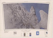
Karte der Region.

Der Dott Ice Rise ist ein Ice-Rise in der Westantarktis. Die halbinsel-artige, fast vollständig vom Eis bedeckte Erhebung ist etwa 20 Seemeilen (37 km) lang und erstreckt sich östlich der Heritage Range, dem südlichen Teil des Ellsworthgebirges, bis zur eisgefüllten Bucht Constellation Inlet am südwestlichen Rand des Ronne-Schelfeises.[1] Er ist über den Isthmus Johnson Neck mit der östlichen Seite der Pioneer Heights verbunden.[2] Die Barrett Nunataks sind der einzige Teil des Ice-Rises, der über das Eis hinausragt.[1]

Dott Ice Rise wurde vom United States Geological Survey im Rahmen der Erfassung der Heritage Range in den Jahren 1961–66 durch Vermessungen vor Ort und Luftaufnahmen der United States Navy kartografiert. Das amerikanische Advisory Committee on Antarctic Names benannte den Ice-Rise nach dem Geologen des United States Antarctic Program Robert H. Dott, der im Sommer 1961–62 auf der chilenischen Forschungsstation Bernardo O’Higgins als oberster Vertreter der Vereinigten Staaten vor Ort tätig war.[1]

Einzelnachweise

  1. a b c Dott Ice Rise (Englisch). Geographic Names Information System. United States Geological Survey. Abgerufen am 16. Juli 2010.
  2. Johnson Neck (Englisch). Geographic Names Information System. United States Geological Survey. Abgerufen am 16. Juli 2010.

Wikimedia Foundation.

Игры ⚽ Поможем решить контрольную работу

Schlagen Sie auch in anderen Wörterbüchern nach:

  • Dott Ice Rise — (79°18′S 81°48′W / 79.3°S 81.8°W / 79.3; 81.8) is a peninsula like feature that is ice drowned except for the Barrett Nunataks, about 20 nautical miles (37 km) long, extending eastward from the Herita …   Wikipedia

  • Ice rise — An ice rise is a clearly defined elevation of the otherwise totally flat ice shelf, typically dome shaped and rising 100 to 200 meters above the surrounding ice shelf. An ice rise forms where the ice shelf touches the rocky seabed because of an… …   Wikipedia

  • Constellation Inlet — (78°30′S 80°30′W / 78.5°S 80.5°W / 78.5; 80.5) is an ice filled inlet, 30 miles (50 km) long and 10 miles (16 km) wide, between the Dott Ice Rise and the …   Wikipedia

  • Barrett Nunataks — 79.297222222222 81.403611111111 Koordinaten: 79° 18′ S, 81° 24′ W …   Deutsch Wikipedia

  • Johnson Neck (Antarktis) — 79.45 82.333333333333 Koordinaten: 79° 27′ 0″ S, 82° 20′ 0″ W …   Deutsch Wikipedia

  • October 2009 in sports — Worldwide current events | Sports events …   Wikipedia

  • sedimentary rock — Rock formed at or near the Earth s surface by the accumulation and lithification of fragments of preexisting rocks or by precipitation from solution at normal surface temperatures. Sedimentary rocks can be formed only where sediments are… …   Universalium

  • plate tectonics — plate tectonic, adj. Geol. a theory of global tectonics in which the lithosphere is divided into a number of crustal plates, each of which moves on the plastic asthenosphere more or less independently to collide with, slide under, or move past… …   Universalium

  • List of fictional books — A fictional book is a non existent book created specifically for (i.e. within) a work of fiction. This is not a list of works of fiction (i.e., actual novels, mysteries, etc), but rather imaginary books that do not actually exist.UsesSuch a book… …   Wikipedia

  • List of teetotalers — List of well known people who are now teetotal or were during their lifetime. Note that some have abstained their entire lives, but others have only abstained after prolonged alcohol use.List of well known teetotalersA to E*John Bodkin Adams,… …   Wikipedia

Share the article and excerpts

Direct link
Do a right-click on the link above
and select “Copy Link”