Edward River (New South Wales)
- Edward River (New South Wales)
-
| Edward River |
|
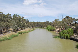
Edward River in DeniliquinVorlage:Infobox Fluss/KARTE_fehlt
|
| DatenVorlage:Infobox Fluss/GKZ_fehlt |
| Lage |
New South Wales (Australien) |
| Flusssystem |
Murray River |
| Abfluss über |
Murray River → Indischer Ozean |
| Quelle |
Picnic Point (Murray River)
34° 58′ 31″ S, 143° 28′ 58″ O-34.97528653143.48274202110 |
| Quellhöhe |
110 m[1] |
| Mündung |
Murray River bei Haysdale (VIC)
-35.8506606144.999581361.2
35° 51′ 2″ S, 144° 59′ 58″ O-35.8506606144.999581361.2 |
| Mündungshöhe |
61,2 mVorlage:Infobox Fluss/NACHWEISE_fehlen |
| Höhenunterschied |
48,8 m |
| Länge |
383 km[1]Vorlage:Infobox Fluss/EINZUGSGEBIET_fehlt
Vorlage:Infobox Fluss/ABFLUSS_fehlt
|
| Rechte Nebenflüsse |
Tuppal Creek, Back Creek, Cootnite Creek, Billabong Creek, Box Creek |
| Linke Nebenflüsse |
Tumudgery Creek, Wakool River |
| Mittelstädte |
Deniliquin |
| Kleinstädte |
Picnic Point, Moulamein, Moolpa, Kyalite |
Der Edward River ist ein Fluss im Südwesten der Region Riverina im Süden des australischen Bundesstaates New South Wales. Er ist ein nördlicher Seitenarm des Murray River.
Cadell Fault
Vor ca. 25.000 Jahren entstand eine in Nord-Süd-Richtung verlaufende Erdfalte im Gebiet zwischen den heutigen Städten Echuca und Deniliquin, die den Murray River in seinem Lauf nach Westen hinderte. So floss der Murray River im Norden um die Erdfalte herum und schuf das Bett des heutigen Edward River. Der Goulburn River wurde ebenfalls aufgestaut und bildete einen See. Später durchbrachen die Wasser dieses Sees die Erdfalte und liefen über das alte Bett des Goulburn River ab. Der Murray River schloss sich diesem Lauf an, wodurch sein heutiges Bett entstand. Etwa 1/3 des Wassers des Murray River läuft nun durch das alte Flussbett des Goulburn River (das das neue des Murray River ist), während 2/3 über den Edward River abfließen.
Flusslauf
Der Fluss zweigt in Picnic Point als Folge der Cadell Fault vom Murray River nach Norden ab und fließt durch den Eukalyptuswald nach Deniliquin. Dort wendet er seinen Lauf nach Nordwesten, parallel zum Murray River. Er verläuft durch Buschland bis zur Kleinstadt Kyalite, wo der Wakool River in ihn mündet. Etwa 15 km weiter westlich, bei Haysdale, trifft er wieder auf den Hauptarm des Murray River.
Weblinks
Einzelnachweise
- ↑ a b Edward River, NSW. Bonzle.com
Kategorien:
- Flusssystem Murray River
- Fluss in New South Wales
- Fluss in Australien und Ozeanien
Wikimedia Foundation.
Schlagen Sie auch in anderen Wörterbüchern nach:
New South Wales D55 class locomotive — New South Wales D55 class 5616 stands at Junee ready to depart with a train of wheat hopper wagons. Power type Steam Builder Clyde Engineering Build date 1918–1925 … Wikipedia
Rivers of New South Wales — Thunderbolts Way and the bridge over the Little Manning River. This page discusses the rivers and hydrography of the State of New South Wales, Australia. The principal topographic feature of New South Wales is the series of low highlands and… … Wikipedia
Edward River — ist der Name zweier Flüsse in Australien: Edward River (New South Wales), ein Seitenarm des Murray River Edward River (Queensland) Diese Seite ist eine Begriffsklärung zur Unterscheidung mehrerer mit demselben Wort bez … Deutsch Wikipedia
Darlington Point, New South Wales — Darlington Point New South Wales The Punt Hotel … Wikipedia
Elizabeth Farm, New South Wales — Elizabeth Farm is an historic estate in Parramatta, a suburb of Sydney, New South Wales, Australia. Elizabeth Farm [ [http://www.hht.net.au/museums/ef/elizabeth farm : : Historic Houses Trust Elizabeth Farm : : ] ] was the family home of wool… … Wikipedia
The Entrance, New South Wales — Infobox Australian Place | type = town name = The Entrance city = Central Coast state = nsw caption = Pelican feeding at The Entrance lga = Wyong Shire postcode = 2261 pop = 2632 (2006 census) area = 1.4 est = parish = Tuggerah stategov = The… … Wikipedia
History of New South Wales — This article describes the history of the Australian state of New South Wales.Foundation and growthIn 1770 Lieutenant (later Captain) James Cook sailed along the east coast of Australia, the first European to do so. On 22 August, at Possession… … Wikipedia
Croydon Park, New South Wales — Croydon Park Sydney, New South Wales Croydon Park Hotel Population … Wikipedia
Alexandra Canal (New South Wales) — Alexandra Canal is an artificial waterway in southern Sydney, New South Wales, Australia.The canal is Sydney s first inbound waterway.cite news |first=Paola |last=Totaro |title=Fetid drain to become aclean, green corridor |publisher= The Sydney… … Wikipedia
Parry County, New South Wales — Infobox Australian cadastral name = Parry state = New South Wales caption = Location in New South Wales near nw = Nandewar near n = Inglis near ne = Vernon near e = Vernon near se = Hawes near s = Brisbane near sw = Buckland near w =… … Wikipedia
 Commons: Edward River (New South Wales) – Sammlung von Bildern, Videos und Audiodateien