- Elwha River
-
Elwha River 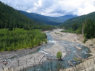
Daten Gewässerkennzahl US: 1531449 Lage Washington (Bundesstaat), USA Flusssystem Elwha River Quelle im Jefferson County
47° 46′ 8,3″ N, 123° 34′ 42,7″ W47.768977-123.5785162Mündung im Clallam County in die Juan-de-Fuca-Straße 48.147222222222-123.566111111110Koordinaten: 48° 8′ 50″ N, 123° 33′ 58″ W
48° 8′ 50″ N, 123° 33′ 58″ W48.147222222222-123.566111111110Mündungshöhe 0 m Länge 72 km (45 Meilen) Gemeinden Elwha Der Elwha River ist ein Fluss auf der Olympic-Halbinsel im US-Bundesstaat Washington; der größte Teil des Flusses liegt im Olympic-Nationalpark. Im Unterlauf des Flusses befinden sich zwei Dämme, die beide zurückgebaut werden sollen. Der Elwha Dam von 1910 bei Flusskilometer 8 und der Clines Canyon Dam von 1927 bei Flusskilometer 21 werden ab September 2011 in einem dreijährigen Projekt abgerissen und das ursprüngliche Wasserregime auf über 70 km wieder hergestellt, die für Wasserlebewesen von der Mündung her bisher nicht zugänglich sind. Im Elwha leben fünf Arten des Pazifik-Lachses. Sie sollen von der Renaturierung des Flusses profitieren. Statt bisher etwa 3000 Exemplaren werden nach Wiederherstellung der Durchlässigkeit für Fische langfristig rund 400.000 laichende Lachse aller im Gebiet vertretener Arten erwartet.[1]
Der Ursprung des Namens Elwha ist ungewiss. Es könnte eine Verballhornung des Ortsnamens e ilth quath (āīlth'q-uȧtt) aus der Sprache der Quileute sein. Einer anderen Theorie zufolge leitet er sich ab vom Wort der Klallam für Wapiti, elkwah, oder vom Namen des Klallam-Dorfes, das sich einst am Ufer des Flusses befand. Die erste dokumentierte Verwendung des Namens Elwha für den Fluss ist Henry Kelletts Landkarte von 1846.[2]Inhaltsverzeichnis
Siehe auch
Literatur
- Elizabeth Grossman: Watershed: The Undamming of America. 2002, ISBN 1-58243-108-6.
Weblinks
- Elwha River Restoration
- Elwha dam removal gets final go-ahead - The Seattle Times
- Elwha River Ecosystem and Fisheries Restoration Act PL 102-495
- Unconquering the Last Frontier, a film by Robert Lundahl
- Elwha River Education
- The Lower Elwha Klallam Tribe
- Glines Canyon Dam Removal Animation
- Elwha Dam Removal Animation
- Northwest Science Special Issue
Einzelnachweise
- ↑ National Park Service: Olympic National Park – Elwha River Restoration
- ↑ Smitty Parratt: Gods & goblins: A Field Guide to Place Names of Olympic National Park. CP Publications 1984, ISBN 0-914195-00-X

Wikimedia Foundation.