- Falls of the Ohio State Park
-
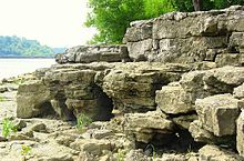
Der Falls of the Ohio State Park ist Fundort von 386 Millionen Jahre alten Fossilien aus dem Devon. Der 67 Hektar große State Park wurde 1990 eingerichtet und ist über den Interstate 65 erreichbar. Er liegt am Ohio River bei Clarksville im Clark County des US-Bundesstaates Indiana.[1]
Die Fossilbetten waren in prähistorischen Zeiten Meeresgrund mit Korallen und anderen Lebewesen, die nach ihrem Tod abgesunken und von Sedimenten überdeckt wurden. Beim Rückzug der Eiszeitgletscher wurden die Deckschichten weggeschwemmt und in der heutigen Zeit sind bei Niedrigwasser 89 ha freigelegte Fossillagerstätten zugänglich. In diesen Jeffersonville Limestone Formationen wurden mehr als 250 Arten versteinerter Korallen und insgesamt über 600 verschiedene Fossilienarten wie Armfüßer, Gliederfüßer, Stachelhäuter, Stromatoporen, Weichtiere und Mikroben gefunden,[2] darunter etwa zwei drittel Erstbeschreibungen.
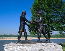
Die "Ohiofälle" sind Stromschnellen mit einem Gefälle von 8 Höhenmetern auf einer Strecke von 4 Flusskilometern, dem einzigen Hindernis für die Schifffahrt im Flusslauf des Ohio River. Der größte Teil der Stromschnellen liegt inzwischen im aufgestauten Bereich hinter dem 1920 erbauten McAlpine-Damm. George Rogers Clark, der ältere Bruder des Entdeckers William Clark, gründete 1783 die Stadt Clarksville. Das Gebiet seiner Wohnstätte gehört ebenfalls zum State Park, auch wenn die Unterkunft nicht mehr erhalten ist.[3]
John James Audubon fertigte 200 Skizzen von 14 Vogelarten während seines Aufenthalts in der Gegend, inzwischen wurden 270 Vogelarten registriert. Im großräumigen Flussabschnitt des Ohios sind 130 Fischarten gelistet, darunter auch gefährdete Löffelstöre.[4][5][6][7]
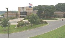
Im Visitor Center sind verschiedene Ausstellungen zur Geologie, Vorgeschichte, Kulturgeschichte und Lokalgeschichte mit über 100 Exponaten, sowie Aquarien, Unterrichtsräume, Beobachtungszonen für Wildtiere und Aussichtsbereiche untergebracht.[8] Im Jahr 2008 wurden über 450.000 Besucher im State Park gezählt.[9]
Einzelnachweise
- ↑ http://www.in.gov/dnr/parklake/2984.htm (abgerufen am 6. September 2010)
- ↑ http://www.fallsoftheohio.org/virtual_tour.html (abgerufen am 6. September 2010)
- ↑ http://www.fallsoftheohio.org/clark_cabin.html (abgerufen am 6. September 2010)
- ↑ http://www.fallsoftheohio.org/fishing.html (abgerufen am 6. September 2010)
- ↑ http://www.fallsoftheohio.org/OhioRiverFishList.html (abgerufen am 6. September 2010)
- ↑ http://www.in.gov/dnr/parklake/files/falls_of_the_ohio_trail.pdf (abgerufen am 6. September 2010)
- ↑ http://www.fallsoftheohio.org/ (abgerufen am 6. September 2010)
- ↑ http://www.fallsoftheohio.org/facilities.html (abgerufen am 6. September 2010)
- ↑ http://www.in.gov/dnr/parklake/files/sp-SPR_Visitation_FY08.pdf (abgerufen am 6. September 2010)
Weblinks
- Falls of the Ohio State Park beim Indiana Department of Natural Resources (engl.)
- http://www.fallsoftheohio.org/
- Avifaunistische Artenliste
- Falls of the Ohio State Park im Geographic Names Information System des United States Geological Survey
38.272491-85.760897129Koordinaten: 38° 16′ 21″ N, 85° 45′ 39″ WBrown County | Chain O' Lakes | Charlestown | Clifty Falls | Falls of the Ohio | Fort Harrison | Harmonie | Indiana Dunes | Lincoln | McCormick’s Creek | Mounds | O’Bannon Woods | Ouabache | Pokagon | Potato Creek | Prophetstown | Shades | Shakamak | Spring Mill | Summit Lake | Tippecanoe River | Turkey Run | Versailles | Whitewater Memorial | White River
Wikimedia Foundation.


