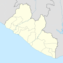
False Cape Mount

False Cape Mount
6.7151111111111-11.368166666667
False Cape Mount (Liberia)
False Cape Mount
False Cape Mount

Das False Cape Mount (deutsch: das falsche Kap Mount) an der westafrikanischen Atlantikküste ist ein markanter Punkt der liberianischen Küste, erkennbar als auffälliger, dicht bewaldeter Berg. Es befindet sich kaum vier Kilometer östlich vom „richtigen“ Kap Mount und konnte deshalb bei schlechter Sicht (dunstige Atmosphäre oder Regen) leicht mit dem richtigen Seezeichen verwechselt werden. In historischen englischen Seekarten des 17. Jahrhunderts wurde das bei Robertsport liegende Kap auch mit Little Cape Mount oder Half Cape Mount bezeichnet.[1]

Geschichte

Der erste Europäer, der die Küstenregion um Kap Mount erreichte, war 1458 der portugiesische Entdecker Diogo Gomes. Er bereiste im Auftrag Heinrichs des Seefahrers die afrikanische Westküste. Eine genauere Untersuchung der Pfefferküste, zu dem diese Region gehört, wurde von Pieto de Sintra und Luis de Cadamosto vorgenommen.[1]

Literatur

  • National Geospatial-Intelligence Agency (Hrsg.): NGA Sailing Directions-Enroute: 2008 West Coast of Europe and Northwest Africa. Pub. 143, Annapolis MD 2008, ISBN 1-57785-885-9, Sierra Leone and Liberia – The Banana Islands to Cape Palmas, S. 253. (relevanter Textabschnitt als Digitalisat, englisch)

Einzelnachweise

  1. a b Jacqueline Penjon, Georges Boisvert, Anne-Marie Quint: Vents du large: hommage à Georges Boisvert. Éditeur Presses Sorbonne Nouvelle, Paris 2002, ISBN 2-87854-240-1, Cabo cortês ou cabo mesurado…, S. 32–33. (relevanter Textabschnitt als Digitalisat, französisch)

Wikimedia Foundation.

Игры ⚽ Поможем написать курсовую

Schlagen Sie auch in anderen Wörterbüchern nach:

  • Mount Joy Pond Natural Area Preserve — is a Natural Area Preserve located in Augusta County, Virginia in the United States. Located on the western side of the Blue Ridge Mountains, it supports a large population of the rare Virginia sneezeweed. This and other plants are associated… …   Wikipedia

  • Cape Henry Light — Cape Henry Lighthouse U.S. National Register of Historic Places U.S. National Historic Landmark …   Wikipedia

  • Mount Rogers National Recreation Area — Coordinates: 36°38′46″N 81°34′58″W / 36.64611°N 81.58278°W / 36.64611; 81.58278 …   Wikipedia

  • Cape Horn — Cabo de Hornos redirects here, for the Chilean commune see Cabo de Hornos, Chile. Cape Horn island (Dutch: Kaap Hoorn ; Spanish: Cabo de Hornos ; named after the city of Hoorn in the Netherlands) is the southernmost headland of the Tierra del… …   Wikipedia

  • Mount Trashmore Park — This article is about the Virginia Beach site. For other uses of the term, see Mount Trashmore (disambiguation). Mount Trashmore in Virginia Beach Mount Trashmore Park, also known simply as Mount Trashmore, is a city park located in Virginia… …   Wikipedia

  • Cape York Melomys — Cape York Mosaic tailed Rat Conservation status Least Concern (IUCN 3.1)[1] …   Wikipedia

  • Mount Lowe Railway — U.S. National Register of Historic Places …   Wikipedia

  • Kap Mount — 6.7275 11.365555555556 Koordinaten: 6° 43′ 39″ N, 11° 21′ 56″ W …   Deutsch Wikipedia

  • Mount Hope Bay raids — Part of the American Revolutionary War …   Wikipedia

  • Battle of Cape St. Vincent (1780) — Battle of Cape St. Vincent Part of the America …   Wikipedia

Share the article and excerpts

Direct link
Do a right-click on the link above
and select “Copy Link”