Gila National Forest

Gila National Forest

Der Gila National Forest ist ein Nationalforst der Vereinigten Staaten, der im südwestlichen New Mexico liegt. Er grenzt im Westen an den Apache-Sitgreaves National Forest, der im benachbarten Staat Arizona liegt. Er umfasst 13.454 Quadratkilometer, wovon 88% als Waldland klassifiziert sind.[1] Der ganzjährig wasserführende Gila River durchfließt Teile des Gila National Forest.

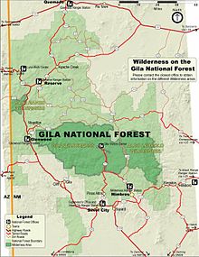
Karte des Gila National Forest

Im Gila National Forest und den angrenzenden Nationalforsten Arizonas wurde der Mexikanische Wolf wieder eingeführt, der bereits in freier Wildbahn ausgestorben war. Im Gebiet liegen verschiedene Wildnis-Schutzgebiete, die als Wilderness bezeichnet werden. Eines darunter ist die 2.260 Quadratkilometer große Gila Wilderness. Die Region is von Bergland geprägt, in dem die Gelb-Kiefer als Baumart dominiert. Vor allem an den Bergfüßen kommen immergrüne Eichen und Wacholder vor. In den Tälern herrschen Strauchlandschaften vor. Zwischen den Wäldern und Parklandschaften liegen immer wieder offene Graslandbereiche. Zu den größeren Tieren des Gebietes zählen Wapitis, Maultierhirsche, Weißwedelhirsche, Dickhornschafe und Halsbandpekaris. Den benachbarten Apache-Sitgreaves National Forest eingerechnet kommen im Gebiet 57.000 Weißwedel- beziehungsweise Maultierhirsche und 16.000 Wapitihirsche vor.[2]

Daneben kommen Schwarzbären und Pumas im Gebiet vor. Wanderern im Bereich der Gila Wilderness wird etwa empfohlen Lebensmittel vom Schlafplatz entfernt aufzubewahren um diese Raubtiere nicht anzulocken.[3]

Im Bereich des Gila National Forest soll zudem der Jaguar in der jüngeren Vergangenheit wiederholt gesichtet worden sein.[4]

Quellen

  1. John D. Shaw: Forest Resources of the Gila National Forest. United States Department of Agriculture Forest Service. Rocky Mountain Research Station, May 2008. PDF
  2. David R. Parsons: "Green Fire" Returns to the Southwest: Reintroduction of the Mexican Wolf. Source: Wildlife Society Bulletin, Vol. 26, No. 4, Commemorative Issue Celebrating the 50th Anniversary of "A Sand County Almanac and the Legacy of Aldo Leopold (Winter, 1998), pp. 799-807 PDF
  3. FOREST SERVICE GILA NATIONAL FOREST U. S. Department of Agriculture: BACKPACKING IN THE GILA WILDERNESS. Wilderness Ranger District PDF
  4. Michael J. Robinson: Habitat for Jaguars in New Mexico. (maps by Curtis Bradley and Jeff Boyd) produced in cooperation with the Jaguar Conservation Team’s Habitat Subcommittee. January 2006. PDF
33.5-108.66666666667

Wikimedia Foundation.

Игры ⚽ Нужно решить контрольную?

Schlagen Sie auch in anderen Wörterbüchern nach:

  • Gila National Forest — The Gila National Forest is a protected national forest in New Mexico in the southwestern United States established in 1905. It covers approximately 3.3 million acres (5150 sq. mi., 13,000 km²) of public land, making it the sixth largest National …   Wikipedia

  • National Forest — Tongass Nationalforst in Alaska Ein Nationalforst (engl. National Forest) ist in den Vereinigten Staaten von Amerika ein Waldgebiet unter der Kontrolle der Bundesregierung, das vom US Forest Service verwaltet wird. Größter Nationalforst ist mit… …   Deutsch Wikipedia

  • Datil National Forest — was established in New Mexico by the U.S. Forest Service on June 18, 1908 with 1,255,883 acres (5,082.38 km2) from Gila National Forest and other lands. On February 23, 1909 Magdalena National Forest and other areas were added. On December… …   Wikipedia

  • Big Burros National Forest — was established by the U.S. Forest Service in New Mexico on February 6, 1907 with 156,780 acres. On June 18, 1908 Big Burros was combined with Gila National Forest and the name was discontinued. [citation|title=PDFlink|… …   Wikipedia

  • Apache-Sitgreaves National Forest — Der Apache Sitgreaves National Forest ist ein Nationalforst in den Vereinigten Staaten. Es handelt sich um zwei insgesamt 8.000 km² große Waldgebiete, die sich entlang der Mogollon Kette und der White Mountains im östlichen Arizona bis hinein… …   Deutsch Wikipedia

  • Coconino National Forest — IUCN Category VI (Managed Resource Protected Area) …   Wikipedia

  • Coronado National Forest — IUCN Category VI (Managed Resource Protected Area) …   Wikipedia

  • Cibola National Forest — Map of Cibola National Forest. The Cibola National Forest is a 1,631,266 acres (6,601.5 km2) United States National Forest in western and central New Mexico, USA. [1] The forest also manages four National Grasslands that stretch from… …   Wikipedia

  • Tonto National Forest — Infobox protected area | name = Tonto National Forest iucn category = VI caption = locator x = 61 locator y = 115 location = Gila, Maricopa, Yavapai, and Pinal counties, Arizona, USA nearest city = Payson, Arizona lat degrees = lat minutes = lat… …   Wikipedia

  • Crook National Forest — was established in Arizona by the U.S. Forest Service on July 1, 1908 with 788,624 acres (3,191.45 km2) from portions of Tonto National Forest, Mount Graham National Forest and other lands. On July 1, 1953 Crook was divided among Tonto, Gila …   Wikipedia

Share the article and excerpts

Direct link
Do a right-click on the link above
and select “Copy Link”