Glen Iorsa

Glen Iorsa
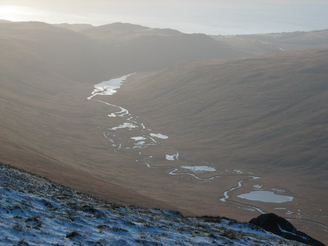
Glen Iorsa mit Iorsa Water und Loch Iorsa

Glen Iorsa ist das größte Tal auf der schottischen Insel Arran. Es zieht sich beginnend am Loch na Davie etwa sechs Kilometer nordwestlich des Gipfels des Goat Fell in 360 m Höhe in südwestlicher Richtung bis kurz vor den Kilbrannan-Sund bei Dougarie an der Westküste Arrans hin. Im Verlauf des etwa 13,5 km langen Tals finden sich zahlreiche kleine Seen, von denen Loch Iorsa der größte ist, sowie der Bach Iorsa Water.[1] Aus westlicher Richtung münden zwei Schluchten in den Glen Iorsa und mehrere Gebirgsbäche münden in das Iorsa Water.

Glen Iorsa verläuft durch eine abgelegene Landschaft und es existieren keine ständig bewohnten Behausungen. Durch und um Glen Iorsa sind verschiedene Wanderrouten mit unterschiedlichen Schwierigkeitsgraden beschrieben. Die nächstgelegene Siedlung ist Dougarie.[2]

Einzelnachweise

  1. F. H. Groome (Hrsg.): Ordnance Gazetteer of Scotland: A Survey of Scottish Topography, Statistical, Biographical and Historical, Grange Publishing Works, Edinburgh, 1882–1885.
  2. P. Dillon: Walking on the Isle of Arran, Cicerone, 2. Auflage, 2006. ISBN 978-1-852-84478-3
55.622222222222-5.275

Wikimedia Foundation.

Игры ⚽ Поможем сделать НИР

Schlagen Sie auch in anderen Wörterbüchern nach:

  • Iorsa Water — Lauf des Iorsa Water durch Glen Iorsa mit dem Loch Iorsa …   Deutsch Wikipedia

  • Loch Iorsa — mit Bootshaus Geographische Lage Schottland Zuflüsse …   Deutsch Wikipedia

  • Loch na Davie — Geographische Lage Schottland Abfluss Ranza …   Deutsch Wikipedia

  • Isle of Arran — This article is about the Scottish island. For other uses, see Arran. Isle of Arran Location OS grid reference …   Wikipedia

  • Arran Whitebeams — Taxobox name = Arran Whitebeams image width image caption = regnum = Plantae divisio = Magnoliophyta classis = Magnoliopsida ordo = Rosales familia = Rosaceae subfamilia = Maloideae genus = Sorbus subgenus = Aria species = S. arranensis S.… …   Wikipedia

  • Île d'Arran — Pour les articles homonymes, voir Arran.  Ne doit pas être confondu avec Îles d Aran. Île d Arran Isle of Arran  …   Wikipédia en Français

  • Beinn Tarsuinn (Corbett) — Infobox Mountain Name = Beinn Tarsuinn Photo = Beinn Tarsuinn.jpg Caption = From Goat Fell to the east Elevation = 826 m (2,710 ft) Location = Isle of Arran, SCO Prominence = 235 m Parent peak = Caisteal Abhail Coordinates = Topographic OS… …   Wikipedia

  • Isle of Arran — Lage der Isle of Arran Gewässer Firth of Clyde Geographische Lage …   Deutsch Wikipedia

  • List of rivers of Scotland — List of rivers in Scotland is a list of rivers in Scotland, organised geographically, taken anti clockwise, from Berwick upon Tweed. Tributaries are listed down the page in an upstream direction.For simplicity, they are divided here by the nation …   Wikipedia

  • Liste Des Cours D'eau D'Écosse — La liste des cours d eau d Écosse recense les principaux fleuves d Écosse, classés de manière géographique dans le sens inverse des aiguilles d une montre à partir de Berwick upon Tweed. Les affluents sont eux classés dans le sens de leur courant …   Wikipédia en Français

Share the article and excerpts

Direct link
Do a right-click on the link above
and select “Copy Link”