Glen Innes (New South Wales)

Glen Innes (New South Wales)
Glen Innes
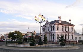
Glen Innes (6).JPG
Grey Street
Staat: Australien Australien
Bundesstaat: Flag of New South Wales.svg New South Wales
Gegründet: 1852
Koordinaten: 29° 45′ S, 151° 44′ O-29.75151.736111111111062Koordinaten: 29° 45′ S, 151° 44′ O
Höhe: 1.062 m
 
Einwohner: 5.944 (2006) [1]
 
Zeitzone: AEST (UTC+10)
Postleitzahl: 2370
LGA: Glen Innes Severn Council
Glen Innes (Australien)
Glen Innes
Glen Innes
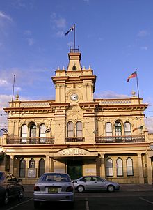
Town Hall

Glen Innes ist eine Stadt mit etwa 6.000 Einwohnern im Norden des australischen Bundesstaat New South Wales. Sie befindet sich 600 Kilometer nördlich von Sydney und 360 Kilometer südwestlich von Brisbane an der Kreuzung des New England Highway mit dem Gwydir Highway. Die Stadt ist der Verwaltungssitz des Verwaltungsgebiet (LGA) Glen Innes Severn Council.

Die Produktion von Wolle, sowie die Rinder- und Schafzucht sind seit 150 Jahren die Hauptwirtschaftszweige in dieser Region. Daneben spielt die Holzproduktion und der Abbau von Saphiren eine Rolle. Mit der Aufnahme der Gondwana-Regenwälder in dem nahe gelegenen Gibraltar-Range- und Washpool-Nationalpark in das UNESCO-Weltnaturerbe, gewinnt der Tourismus zunehmend an Bedeutung.

Geschichte

Etwa 1838 kamen als erste Europäer zwei Viehzüchter, wegen ihrer langen Bärte auch bekannt als the Beardies, in die Gegend um Glen Innes. 14 Jahre später 1852 wurde dann die Stadt gegründet, benannt nach dem schottischen Siedler Major Archibald Clunes Innes. Das erste Postamt entstand 1854 und das Gerichtsgebäude wurde 1858 errichtet. Im Jahr 1866 wohnten etwa 350 Menschen in der Stadt. Erst nachdem in der Nähe von Emmaville im Jahr 1872 Zinn entdeckt wurde stieg die Einwohnerzahl deutlich an und erreichte drei Jahre später 1.500.[2][3]

Weblinks

 Commons: Glen Innes – Sammlung von Bildern, Videos und Audiodateien

Einzelnachweise

  1. Australian Bureau of Statistics (25. Oktober 2007): Glen Innes (Urban Centre/Locality) (Englisch). 2006 Census QuickStats. Abgerufen am 18. August 2011.
  2. Readers Digest Guide to Australian Places, Readers Digest, Sydney
  3. Geschichte von Glen Innes. Abgerufen am 18. September 2011 (englisch)

Wikimedia Foundation.

Игры ⚽ Поможем сделать НИР

Schlagen Sie auch in anderen Wörterbüchern nach:

  • Glen Innes, New South Wales — Infobox Australian Place | type = town name = Glen Innes state = nsw caption = Grey Street, Glen Innes NSW lga = Glen Innes Severn Shire Council county = Gough postcode = 2370 est = 1852 pop = 5,944 elevation= 1062 maxtemp = 20.2 mintemp = 7.2… …   Wikipedia

  • New England (New South Wales) — New England New South Wales Mount Duval in New England Population …   Wikipedia

  • Wellingrove, New South Wales — Wellingrove is a village located on the Wellingrove Road about 20 kilometres north west of Glen Innes, New South Wales on the Northern Tablelands, New South Wales, Australia. It is part of the Glen Innes Severn Shire Council local government area …   Wikipedia

  • New South Wales Legislative Assembly electoral districts — The New South Wales Legislative Assembly is elected from 93 single member electorates called districts. Current districts This is a list of districts for the 2007 general election.* Albury * Auburn * Ballina * Balmain (1880 1894: Balmain; 1894… …   Wikipedia

  • Glen Innes — may refer to: * Glen Innes, New South Wales, a town in Australia * Glen Innes, New Zealand, a suburb of Auckland …   Wikipedia

  • Glen Innes — bezeichnet: Glen Innes (New South Wales), einen Ort in Australien Glen Innes (Neuseeland), eine Vorstadt von Auckland in Neuseeland Diese Seite ist eine Begriffsklärung zur Unterscheidung mehrerer mit demselben Wort bezeichneter Begriffe …   Deutsch Wikipedia

  • Clive County, New South Wales — Map of all coordinates from Google Map of all coordinates from Bing Export all coordinates as KML …   Wikipedia

  • Ben Lomond, New South Wales — Infobox Australian Place | type = town name = Ben Lomond state = nsw caption = Ben Lomond Church with The Brothers Mountain to the right. lga = Guyra Shire Council county = Hardinge postcode = 2365 est = pop = 389 elevation= 1400 maxtemp =… …   Wikipedia

  • Red Range, New South Wales — Red Range is a village with a population of 254 (in 2006) on the Northern Tablelands region of New South Wales, Australia in Glen Innes Severn Shire. It is in the Parish of Rusden and Gough County. The village is located on the Red Range Road… …   Wikipedia

  • North Star, New South Wales — North Star is a small village in northern New South Wales near the Queensland border. At the 2006 census, North Star had a population of 327 people.[1] Contents 1 Facilities 2 Railway 2.1 …   Wikipedia

Share the article and excerpts

Direct link
Do a right-click on the link above
and select “Copy Link”