Hajigak-Pass

Hajigak-Pass

xBWxx

Hajigak-Pass
Osten Westen
Passhöhe 3.500 m
Talorte Gardan Diwal Bamiyan
Ausbau Passstraße
Gebirge Koh-i Baba
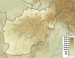
Karte (Wardak)
Hajigak-Pass (Afghanistan)
Hajigak-Pass
Koordinaten 34° 39′ 34″ N, 68° 5′ 10″ O34.659468.0863500Koordinaten: 34° 39′ 34″ N, 68° 5′ 10″ O

Der Scheitelpunkt des Hajigak-Passes (hajji gak bedeutet kleiner Pilger) in der afghanischen Provinz Bamiyan liegt 3500 Meter hoch. Der Pass überwindet auf dem Weg von Kabul nach Bamiyan in Zentral-Afghanistan das Koh-i Baba-Gebirge. Von Kabul ausgehend führt der Weg zunächst über den Unai-Pass, dann hinunter nach Gardan Diwal und wieder hinauf zum Hajigak-Pass. Da dieser sehr hoch liegt, kann er bei Schneefall nicht befahren werden. Ein anderer Weg nach Bamiyan führt über den Shibar-Pass, der lediglich 3.000 Meter Höhe überwindet. Daher wird dieser häufiger befahren.

In den Bergen von Hajigak befindet sich ein Eisenvorkommen, das auf 1,8 Millionen Tonnen geschätzt wird.[1]

Weblinks

Einzelnachweis

  1. Minerals of Afghanistan, abgerufen am 12. Dezember 2009 (englisch)

Wikimedia Foundation.

Игры ⚽ Нужен реферат?

Schlagen Sie auch in anderen Wörterbüchern nach:

  • Hajigak Pass — Infobox Mountain Pass Name = Hijigak Pass Photo = Hajigak.jpg Caption = Elevation = 3700 m. Location = AFG Range = Hindu Kush Coordinates = coord|34|40|N|67|57|E|type:pass Topographic Picture =The Hajigak Pass ( hajji gak little pilgrim ) is… …   Wikipedia

  • Unai-Pass — xBWxxx Unai Pass Passhöhe 3.300 m …   Deutsch Wikipedia

  • Shibar Pass — Infobox Mountain Pass Name = Shibar Pass Photo = Caption = Elevation = 3000 m. Location = AFG Range = Hindu Kush Coordinates = coord|34|54|N|68|15|E|type:pass Topographic Picture =Shibar Pass is situated at a height of 3,000 m above sea level and …   Wikipedia

  • Koh-i-Baba — The Baba mountain range, or Koh i Baba in Persian, is a western extension of the Hindu Kush, and the origin of all three of Afghanistan’s major river systems, the Kabul, the Hilmand Arghandab, and the Hari River. It is is crowned by Foladi peak ( …   Wikipedia

  • Shibar District — The Shibar district (pop.: 27,000 in the year 2005) is located in the western end of the Bamyan Province in Afghanistan. It is in a mountainous region. The main village Shibar is at 2,637 m altitude on the all seasons secondary road from Bamyan… …   Wikipedia

  • List of Afghanistan-related topics — This is a list of Afghanistan related articles. See also the .Afghanistan* Afghanistan * SalajeetBuildings and structures in Afghanistan* Buddhas of Bamyan * Chakhil i Ghoundi Stupa * Darul Aman Palace * Kajakai Dam * Tajbeg PalaceArchaeological… …   Wikipedia

  • Hindu Kush — Geobox | Range name = Hindu Kush other name = category = image caption = Mountains of Afghanistan etymology = nickname = country = Afghanistan country1 = Pakistan state = region = Northern Areas district = parent = Himalaya border = highest =… …   Wikipedia

  • Hindukusch — p1 Hindukusch Hindukusch Höchster Gipfel Tirich Mir (7.708 m) …   Deutsch Wikipedia

Share the article and excerpts

Direct link
Do a right-click on the link above
and select “Copy Link”