- Halesworth
-
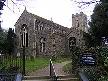 Kirche St. Mary the Virgin
Halesworth ist eine Gemeinde im Distrikt Waveney im Nordosten von Suffolk in England. Halesworth wird von dem Fluss Blyth durchflossen. Im Jahr 2001 zählte die Stadt 4637 Einwohner.
Inhaltsverzeichnis
Verkehr
Durch die Bahnen der East Suffolk Line ist Halesworth mit Ipswich und Lowestoft verbunden. Eine zwischen 1879 und 1924 betriebene Eisenbahnstrecke von Halesworth nach Southwold könnte nach neuen Plänen den Grundstock für eine neue Bahnlinie bilden.
1761 wurde durch den Bau eines Kanals der Fluss schiffbar und das Anlegen von Kohlefrachtern möglich.
Der außerhalb gelegene Flugplatz von Halesworth ist heute in Privatbesitz. 1943 wurde kriegsbedingt mit dem Bau des Flugplatzes begonnen. Anfangs war hier die 56. Fighter Group der 8. United States Army Air Force stationiert. 1944 wurde der Flugplatz außerdem Stützpunkt der 489. Bombergruppe, die an der Operation Overlord beteiligt war. Im November kehrte die Bombergruppe nach Amerika zurück und der Flugplatz wurde von Januar bis Juni 1945 von der 5. Emergency Rescue Squadron benutzt. Im Jahr 1946 endete der Flugbetrieb.
Kirchen
Eine erste Kirche in Halesworth fand bereits im Domesdaybook von 1086 Erwähnung. Die jetzige Kirche St. Mary the Virgin wurde Anfang des 15.Jahrhunderts errichtet, eine Restaurierung fand im späten 19.Jahrhundert statt.
Museen
- Halesworth & District Museum (geöffnet von Mai bis September)
- Halesworth Airfield Museum
Parks
- Millennium Green, das größte in Großbritannien mit rund 44 Hektar Fläche. Die zeitweise beweideten Überschwemmungswiesen sind ein Schutzgebiet für Wildtiere in der Nähe des Stadtzentrums.
- Town park
Veranstaltungen
- Gig in the Park, Musikdarbietung lokaler, nationaler und internationaler Musiker an drei Tagen im August
- Thoroughfair, jährlicher Wohltätigkeitsmarkt in der Fußgängerzone
- Hightide Festival, Uraufführungen von Theater-Produktionen im Mai
Töchter und Söhne der Stadt
- Joseph Dalton Hooker, Botaniker
- George Lansbury, Politiker
Städtepartnerschaften
Links
52.3455555555567.4791666666667Koordinaten: 52° 21′ N, 7° 29′ OKategorie:- Ort in Suffolk

Wikimedia Foundation.