Hardknott Pass

Hardknott Pass
54.40269-3.197118
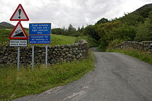
Verkehrszeichen am Fuß des Hardknott-Passes
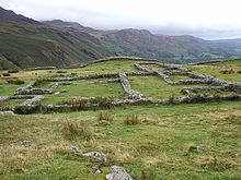
Das römische Fort am Hardknott-Pass

Der Hardknott Pass ist ein Gebirgspass im Lake District in Cumbria, England.

Der Pass liegt auf einer Höhe von 393 m und wird im Norden vom Gipfel des Hart Knott und im Süden vom Gipfel des Harter Fell begrenzt. Von Westen führt eine Straße von Ravenglass durch das Eskdale-Tal über den Hardknott-Pass. Die Straße fällt nach Osten in das Duddon Valley ab. Die Straße wurde im 2. Jahrhundert von den Römern gebaut, um ihren Hafen und das Fort in Ravenglass mit ihrem Fort bei Ambleside zu verbinden. Auf einer Höhe von 200 m befinden sich auf der westlichen Seite des Passes heute noch die Reste eines römischen Forts, das von English Heritage verwaltet wird.

Die Straße ist mit einer Steigung von bis zu 30 Prozent eine der steilsten in England und im Winter oft wegen Eis und Schnee geschlossen.

Weblinks


Wikimedia Foundation.

Игры ⚽ Нужна курсовая?

Schlagen Sie auch in anderen Wörterbüchern nach:

  • Hardknott Pass — is a pass that carries a minor road between Eskdale and the Duddon Valley in the English county of Cumbria, England, in the Lake District National Park. The road approaching the pass vies with Rosedale Chimney Bank in North Yorkshire for the… …   Wikipedia

  • Hardknott Roman Fort — was a fort in the Roman province of Britannia. Its remains are located on the western side of the Hardknott Pass in the English county of Cumbria (formerly part of Cumberland).It was built on a rocky spur giving a superb view over the River Esk… …   Wikipedia

  • Wrynose Pass — The Wrynose Pass is a mountain pass in the Lake District National Park in Cumbria, England between the Duddon Valley and Little Langdale.There is a single track motor road over the pass, which is one of the steepest roads in England, with… …   Wikipedia

  • Wrynose Pass — 54.41505 3.11518 Koordinaten: 54° 24′ 54″ N, 3° 6′ 55″ W …   Deutsch Wikipedia

  • Mediobogdum — Les ruines du fort romain de Hardknott. Lieu Cumbrie Royaume Uni Type d’ouvrage fort r …   Wikipédia en Français

  • Mediobogdum — Coordinates: 54°24′9.82″N 3°12′19.44″W / 54.4027278°N 3.2054°W / 54.4027278; 3.2054 …   Wikipedia

  • Hard Knott — Infobox Mountain Name = Hard Knott Photo = Hard knott.jpg Caption = Hard Knott, seen rising above the Roman fort Elevation = 549 m (1,801 ft) Location = Cumbria, ENG Range = Lake District, Southern Fells Prominence = 154 m Parent peak = Scafell… …   Wikipedia

  • Harter Fell (Eskdale) — To read about the Harter Fell near Mardale in the Lake District, see Harter Fell (Mardale). Infobox Mountain Name = Harter Fell Photo = Harter Fell from Wha House Farm.jpg Caption = Harter Fell as seen from Wha House Farm in Eskdale Elevation =… …   Wikipedia

  • Glannoventa — Les ruines des thermes romains. Lieu Ravenglass  …   Wikipédia en Français

  • Boot, Cumbria — Boot is a small village in Eskdale, Cumbria, in the Lake District of England.There are two roads to access Boot by. One of them is over the Hardknott Pass and Wrynose Pass, Britain s steepest road: it is closed when icy (often, during winter).The …   Wikipedia

Share the article and excerpts

Direct link
Do a right-click on the link above
and select “Copy Link”