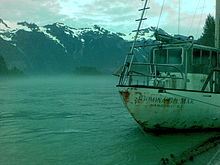
- Homathko River
-
Homathko River 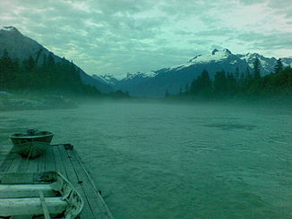
Früher Morgen am Homathko River
Daten Lage British Columbia (Kanada) Flusssystem Homathko River Abfluss über Homathko River → Pazifischer Ozean Quelle Coast Mountains Mündung Bute Inlet (Pazifischer Ozean) 50.931111111111-124.860277777780Koordinaten: 50° 55′ 52″ N, 124° 51′ 37″ W
50° 55′ 52″ N, 124° 51′ 37″ W50.931111111111-124.860277777780Mündungshöhe 0 m Länge 137 km[1] Einzugsgebiet 5.700 km²[1] Abflussmenge[1] MQ: 300 m³/s Der Homathko River ist einer der größeren Flüsse in den südlichen Coast Mountains in British Columbia und einer von wenigen Flüssen, welche die Gebirgskette vom Chilcotin Plateau zu den Fjorden durchschneiden. Er mündet in den Pazifischen Ozean am Ende des Bute Inlet gegenüber der Mündung des Southgate River, etwas östlich davon.
Das Einzugsgebiet des Homathko umfasst eine Fläche von 5.700 km².[1]
Die Berge, welche den Homathko River flankieren, gehören zu den höchsten der Coast Mountains, darunter der Mount Waddington westlich des Flusses in der Waddington Range sowie Mount Queen Bess östlich des Flusses, gegenüber dem Homathko Icefield.
Der Homathko River hat seinen Ursprung im nördlichen Teil der Niut Range, fließt von dort hinab zum Chilcotin Plateau, wendet sich dann nach Süden zum Tatlayoko Lake und durchbricht von dort das Küstengebirge auf dem Weg zum Meer und zum Bute Inlet.
Das Tal des Homathko River ist sehr schwierig zu befahren. Die starke Strömung macht es unmöglich, den Fluss zu überqueren. Das Tal wird von Grizzlybären frequentiert.
Einzelnachweise
 Homathko River
 Kategorien:
- Fluss in British Columbia
- Fluss in Nordamerika


Wikimedia Foundation.