Catarman (Camiguin)

Catarman (Camiguin)
Municipality of Catarman
Lage von Catarman in der Provinz Camiguin
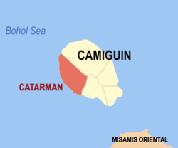
Karte
Basisdaten
Bezirk: Northern Mindanao
Provinz: Camiguin
Barangays: 14
Distrikt: 1. Distrikt von Camiguin
PSGC: 101801000
Einkommensklasse: 5. Einkommensklasse
Haushalte: 3236
Zensus 1. Mai 2000
Einwohnerzahl: 16.060
Zensus 1. August 2007
Koordinaten: 9° 8′ N, 124° 41′ O9.126124.676Koordinaten: 9° 8′ N, 124° 41′ O
Postleitzahl: 9104
Bürgermeister: Jose Antonio G. Gabucan
Offizielle Webpräsenz: Catarman
Geographische Lage auf den Philippinen
Catarman (Philippinen)
Catarman
Catarman

Catarman ist eine philippinische Stadtgemeinde in der Provinz Camiguin. Nach dem Zensus vom 1. Mai 2000 hat sie 15.386 Einwohner in 3236 Haushalten.

Baranggays

Catarman ist politisch in 14 Baranggays unterteilt.

  • Alga
  • Bonbon
  • Bura
  • Catibac
  • Compol
  • Lawigan
  • Liloan
  • Looc
  • Mainit
  • Manduao
  • Panghiawan
  • Poblacion
  • Santo Niño
  • Tangaro

Wikimedia Foundation.

Игры ⚽ Поможем написать курсовую

Schlagen Sie auch in anderen Wörterbüchern nach:

  • Catarman, Camiguin — Catarman is a 5th class municipality in the province of Camiguin, Philippines. According to the 2000 census, it has a population of 15,386 people in 3,236 households.BarangaysCatarman is politically subdivided into 14 barangays.* Alga * Bonbon *… …   Wikipedia

  • Catarman — ist der Name einer philippinischen Stadtgemeinde in der Provinz Camiguin, siehe Catarman (Camiguin) einer philippinischen Stadtgemeinde in der Provinz Northern Samar, siehe Catarman (Northern Samar) eines philippinischen Vulkans, siehe Hibok… …   Deutsch Wikipedia

  • Catarmán — Saltar a navegación, búsqueda Catarmán es el nombre de dos localidades filipinas: Catarmán (Camiguín); Catarmán (Samar del Norte). Obtenido de Catarm%C3%A1n Categoría: Wikipedia:Desambiguación …   Wikipedia Español

  • Catarman — is the name of two places in the Philippines:*Catarman, Camiguin *Catarman, Northern Samar …   Wikipedia

  • Camiguin — This is the article on the island province of Camiguin in the Philippines. There is a different Camiguin Island, part of the Babuyan Islands, also in the Philippines. Infobox Philippine province name = Camiguin sealfile = Ph seal camiguin.png… …   Wikipedia

  • Camiguin — Lage der Provinz Camiguin Karte mit Camiguin im südlichen Teil der Boholsee Camiguin ist e …   Deutsch Wikipedia

  • Camiguin — 9° 10′ 00″ N 124° 43′ 01″ E / 9.16667, 124.717 …   Wikipédia en Français

  • Camiguin — ▪ island, Philippines       mountainous island in the Bohol (Mindanao) Sea, 6 miles (10 km) off the northern coast of Mindanao, Philippines. Located near Macajalar and Gingoog bays, the island is often considered the most beautiful of the… …   Universalium

  • Mambajao, Camiguin — Map of Camiguin showing the location of Mambajao …   Wikipedia

  • Mahinog, Camiguin — Map of Camiguin showing the location of Mahinog Mahinog is a 5th class municipality in the province of Camiguin, Philippines. According to the 2000 census, it has a population of 12,592 people in 2,488 households. It is bounded in the north by… …   Wikipedia

Share the article and excerpts

Direct link
Do a right-click on the link above
and select “Copy Link”