Mahinog

Mahinog
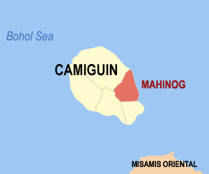
Municipality of Mahinog
Lage von Mahinog in der Provinz Camiguin
Karte
Basisdaten
Bezirk: Northern Mindanao
Provinz: Camiguin
Barangays: 13
Distrikt: 1. Distrikt von Camiguin
PSGC: 101803000
Einkommensklasse: 5. Einkommensklasse
Haushalte: 2488
Zensus 1. Mai 2000
Einwohnerzahl: 13.168
Zensus 1. August 2007
Koordinaten: 9° 9′ N, 124° 47′ O9.15124.78333333333Koordinaten: 9° 9′ N, 124° 47′ O
Postleitzahl: 9101
Geographische Lage auf den Philippinen
Mahinog (Philippinen)
Mahinog
Mahinog

Mahinog ist eine philippinische Stadtgemeinde in der Provinz Camiguin. Nach dem Zensus vom 1. Mai 2000 hat sie 12.592 Einwohner in 2488 Haushalten.

Mahinog grenzt im Norden an Mambajao im Süden an die Stadtgemeinde Guinsiliban, im Osten an die Mindanaosee und im Westen an den Mt. Timpoong.

Baranggays

Mahinog ist politisch in 13 Baranggays unterteilt.

  • Benoni
  • Binaliwan
  • Catohugan
  • Hubangon
  • Owakan
  • Poblacion
  • Puntod
  • San Isidro
  • San Jose
  • San Miguel
  • San Roque
  • Tubod
  • Tupsan Pequeño

Wikimedia Foundation.

Игры ⚽ Нужен реферат?

Schlagen Sie auch in anderen Wörterbüchern nach:

  • Mahinog — Original name in latin Mahinog Name in other language Mahinog, Mallinog State code PH Continent/City Asia/Manila longitude 9.15778 latitude 124.7875 altitude 28 Population 2781 Date 2012 01 17 …   Cities with a population over 1000 database

  • Mahinog, Camiguin — Map of Camiguin showing the location of Mahinog Mahinog is a 5th class municipality in the province of Camiguin, Philippines. According to the 2000 census, it has a population of 12,592 people in 2,488 households. It is bounded in the north by… …   Wikipedia

  • Camiguin — This is the article on the island province of Camiguin in the Philippines. There is a different Camiguin Island, part of the Babuyan Islands, also in the Philippines. Infobox Philippine province name = Camiguin sealfile = Ph seal camiguin.png… …   Wikipedia

  • PH-CAM — Lage der Provinz Camiguin Camiguin ist eine philippinische Provinz und Insel. Sie liegt nur 10 km nördlich der großen Insel Mindanao, der südlichsten Insel der Philippinen. Von der Nordküste Camiguins aus kann man noch gut die Silhouette der 54… …   Deutsch Wikipedia

  • Камигин — тагальск. Kamiguin Страна Филиппины Статус провинция Входит в Регион Северный Минданао Включае …   Википедия

  • Mambajao, Camiguin — Map of Camiguin showing the location of Mambajao …   Wikipedia

  • List of cities and municipalities in the Philippines — This is a list of cities and municipalities in the Philippines arranged by province and in alphabetical order. As of 2006, there are 118 cities and 1509 municipalities.As of September 4, 2007, there are 136 cities, 1,495 municipalities, 81… …   Wikipedia

  • List of ZIP Codes in the Philippines — In the Philippines, the Philippine ZIP code is used by the Philippine Postal Corporation (Philpost) to simplify the distribution of mail. While in function it is similar to the ZIP code used in the United States, its form and its usage is quite… …   Wikipedia

  • Camiguin — Lage der Provinz Camiguin Karte mit Camiguin im südlichen Teil der Boholsee Camiguin ist e …   Deutsch Wikipedia

  • Catarman (Camiguin) — Municipality of Catarman Lage von Catarman in der Provinz Camiguin Basisdaten Bezirk …   Deutsch Wikipedia

Share the article and excerpts

Direct link
Do a right-click on the link above
and select “Copy Link”