Hurricane Alley

Hurricane Alley
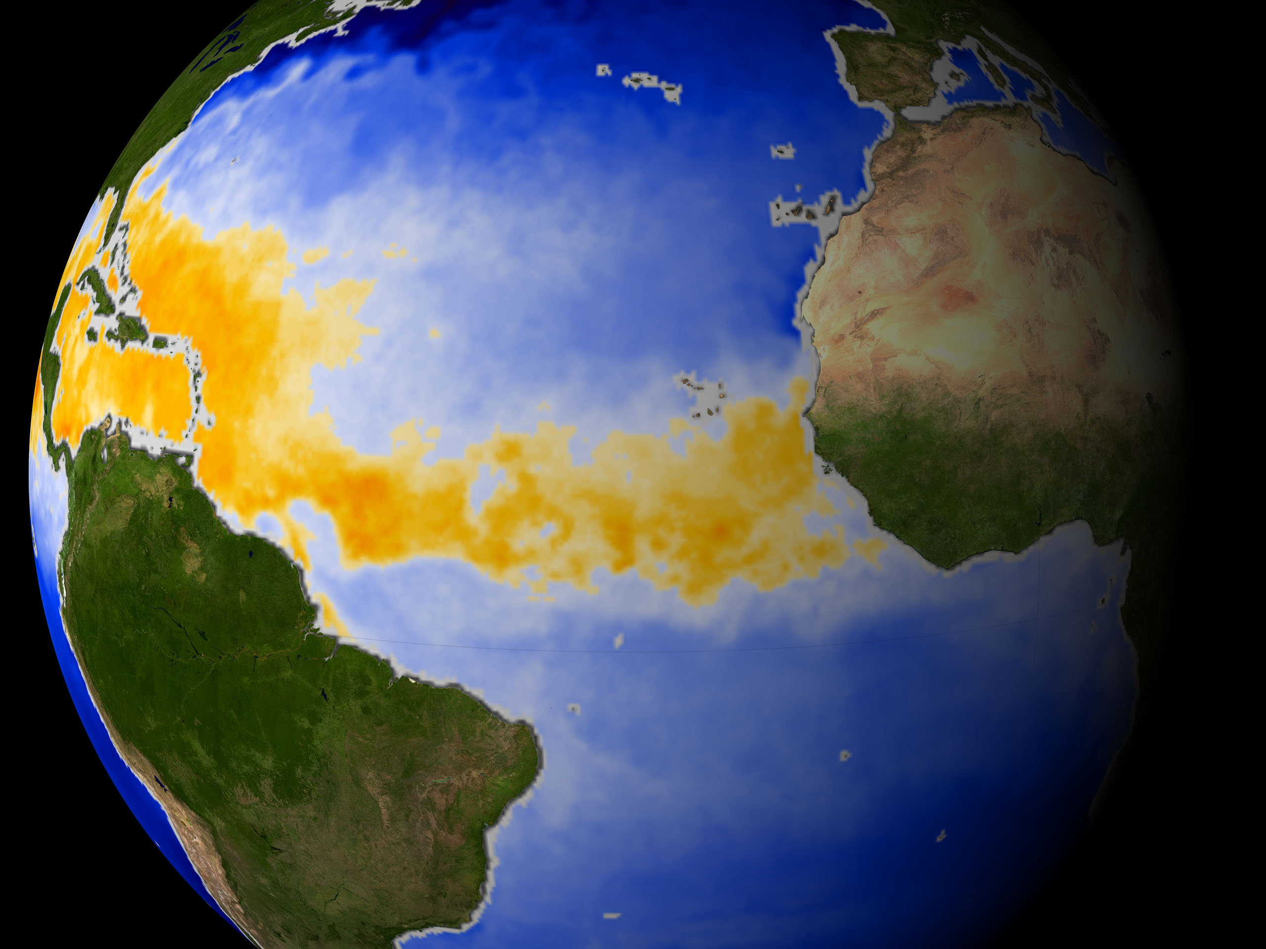
Bereich des wärmeren Wassers im Atlantik

Die Hurricane Alley (dt.: Bahn der Hurrikane) ist ein Bereich mit wärmerem Wasser als im übrigen Atlantischen Ozean dadurch können sich viele Hurrikane bilden. Diese Bahn erstreckt sich von der Westküste des nördlichen Afrika über den Atlantik bis zur Ostküste von Mittelamerika und der Golfküste bis zum Süden der Vereinigten Staaten.

Die Temperatur des Atlantik im Bereich der Hurrikan Alley stieg in den letzten Jahrzehnten stetig.[1] Die Wissenschaftler sind der Meinung, dass dieser Temperaturanstieg einen Beitrag zur Zunahme der Hurrikanaktivität leistet.[2]

Quellen

  1. Earthobservatory at Nasa.gov "Hurricane Alley Heats Up"
  2. LiveScience.com "Hurricane Alley Heats Up"

Wikimedia Foundation.

Игры ⚽ Нужно решить контрольную?

Schlagen Sie auch in anderen Wörterbüchern nach:

  • Hurricane Alley — is an area of warm water in the Atlantic ocean stretching from the west coast of northern Africa to the east coast of central America. It is within this area that many hurricanes form. The temperature of the Atlantic in Hurricane Alley has been… …   Wikipedia

  • Hurricane Alley — …   Useful english dictionary

  • 1937 Atlantic hurricane season — Infobox hurricane season | name=1937 Atlantic hurricane season first storm formed=July 29, 1937 last storm dissipated=Oct. 4, 1937 strongest storm=#5 95 knots (110 mph) total storms=9 major storms=0 total da total fatalities=0 basin=Atlantic… …   Wikipedia

  • Tornado Alley — For the book by William S. Burroughs, see Tornado Alley (book). Tornado Alley is a colloquial term most often used in reference to the area of the United States in which tornadoes are most frequent. Although an official location is not defined,… …   Wikipedia

  • Hawker Hurricane — Hurricane Hurricane Mk I (R4118), which fought in the Battle of Britain Role Fighter …   Wikipedia

  • Damnation Alley — For other uses, see Damnation Alley (disambiguation). Damnation Alley   …   Wikipedia

  • Tropical cyclone — Hurricane redirects here. For other uses, see Hurricane (disambiguation). Hurricane Isabel (2003) as seen from orbit during Expedition 7 of the International Space Station. The eye, eyewall and surrounding rainbands that are characteristics of… …   Wikipedia

  • Tropical cyclone forecast model — [ National Hurricane Center (NHC)] A tropical cyclone forecast model is a computer program that uses meteorological data to forecast the motion and intensity of tropical cyclones. Such models utilize powerful supercomputers with sophisticated… …   Wikipedia

  • 1997–98 South Pacific cyclone season — Season summary map First storm formed: October 8, 1997 Last storm dissipated: May 3, 1998 …   Wikipedia

  • 1998–99 South Pacific cyclone season — Infobox hurricane season Basin=SPac Year=1999 Track=1998 1999 South Pacific cyclone season summary.jpg First storm formed=December 23, 1998 Last storm dissipated=March 18 1999 Strongest storm name=Dani Strongest storm pressure=930 Strongest storm …   Wikipedia

Share the article and excerpts

Direct link
Do a right-click on the link above
and select “Copy Link”