- Inaccessible Islands
-
Inaccessible Islands Karte der Südlichen Orkneyinseln, die Inaccessible Islands ganz im Westen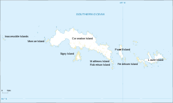
Gewässer Südlicher Ozean Archipel Südliche Orkneyinseln Geographische Lage 60° 34′ S, 46° 44′ W-60.566666666667-46.733333333333Koordinaten: 60° 34′ S, 46° 44′ W 

Anzahl der Inseln Gesamtfläche Einwohner (unbewohnt) Inaccessible Islands (dt. „Unzugängliche Inseln“) sind eine Gruppe kleiner, unbewohnter Inseln im Archipel der Südlichen Orkneyinseln im Südpolarmeer.
Die Inaccessible Islands liegen rund 30 km westlich von Coronation Island, der größten Insel des Archipels, und stellen die westlichste Landmasse der Südlichen Orkneyinseln dar. Sie erheben sich steil aus dem Ozean und erreichen Höhen von 120 bis 215 m über dem Meer.
Die Inseln wurden möglicherweise bereits 1820 von Nathaniel Palmer entdeckt und Seal Islands genannt. Als gesichert gilt die Entdeckung durch den britischen Robbenjäger George Powell vom Dezember 1821, der sie wegen ihrer vermeintlichen Unzugänglichkeit Inaccessible Islands taufte.
Weblinks
Coronation | Fredriksen | Inaccessible Islands | Larsen Islands | Laurie | Matthews | Monroe | Powell | Robertson Islands | Saddle | Signy
Wikimedia Foundation.
Schlagen Sie auch in anderen Wörterbüchern nach:
Inaccessible Islands (South Orkney Islands) — The Inaccessible Islands are a group of small precipituous islands ranging from 120 to 215 m high, the westernmost features of the South Orkney Islands, lying 20 miles west of Coronation Island. The Inaccessible Islands are located at… … Wikipedia
Inaccessible Island (disambiguation) — Inaccessible Island may refer to:*Inaccessible Island, Tristan da Cunha, South Atlantic *Inaccessible Island (Dellbridge Islands) *Inaccessible Islands (South Orkney Islands) … Wikipedia
Inaccessible Island — (dt. „Unzugängliche Insel“) ist der Name einer zu Tristan da Cunha zählenden Insel, siehe Inaccessible einer antarktischen Insel, siehe Inaccessible Island (Antarktis) sowie der ehemalige Name der zu den Crozetinseln zählenden Île des Pingouins… … Deutsch Wikipedia
Inaccessible Island — Infobox World Heritage Site WHS = Gough and Inaccessible Islands State Party = Type = Natural Criteria = vii, x ID = 740 Region = Europe and North America Year = 1995 Session = 19th Extension = 2004 Link =… … Wikipedia
Inaccessible Island (Dellbridge Islands) — Inaccessible Island is a small rocky island, the northernmost of the Dellbridge Islands, lying 1 mile southwest of Cape Evans, Ross Island. Inaccessible Island is located at coord|77|39|S|166|21|E|. Inaccessible Island is the most imposing of the … Wikipedia
Inaccessible — Island Satellitenaufnahme von Inaccessible Gewässer Südatlantik … Deutsch Wikipedia
Inaccessible Island Rail — Taxobox name = Inaccessible Island Rail status = VU | status system = IUCN3.1 trend = stable regnum = Animalia phylum = Chordata classis = Aves ordo = Gruiformes familia = Rallidae genus = Atlantisia genus authority = Lowe, 1923 species = A.… … Wikipedia
List of Antarctic and sub-Antarctic islands — This is a List of Antarctic and sub Antarctic islands. Sub Antarctic islands are islands in the Southern Ocean around Antarctica north of the Antarctic Circle (66° 33 38 ). Antarctic islands are the islands in the Southern Ocean or in the seas… … Wikipedia
South Orkney Islands — Signy Island base and panorama Map of the South Orkney Islands Geography Location … Wikipedia
List of islands of United Kingdom — The United Kingdom of Great Britain and Northern Ireland has thousands of islands within its territory and several external territories. This is a list of selected British islands grouped by Constituent country or Overseas territory. The largest… … Wikipedia
Inaccessible Islands


18+
© Academic, 2000-2026
- Kontaktieren Sie uns: Unterstützung, Werbung
Wörterbücher Export, schritte mit PHP, Joomla, Drupal, WordPress, MODx.