Cavalli Islands

Cavalli Islands
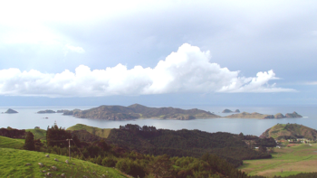
Die Cavalli Islands. Der Hügel ganz rechts auf dem Festland ist das Nordende der Matauri Bay

Die Cavalli Islands sind eine kleine Inselgruppe in Whangaroa an der Ostküste von Northland der Nordinsel Neuseelands

Die Inseln liegen 5 km östlich von Matauri Bay. Die Inselgruppe besteht aus der Insel Motukawanui (3,40 km²) und den kleinen Inseln and Motutapere, Panaki, Nukutaunga, Motuharakeke, Haraweka und Motukawaiti. Die Hauptinsel ist ein Naturreservat, einige der kleineren Inseln sind Privateigentum.

Am 2. Dezember 1987 wurde das nach dem Bombenanschlag französischer Geheimagenten nicht mehr wirtschaftlich zu reparierende Greenpeace-Schiff Rainbow Warrior zwischen Matauri Bay und den Cavalli Islands versenkt, um als Tauchziel und Fischunterschlupf zu dienen.

-34.966666666667173.96666666667

Wikimedia Foundation.

Игры ⚽ Поможем написать реферат

Schlagen Sie auch in anderen Wörterbüchern nach:

  • Cavalli Islands — The Cavalli Islands are a small group of islands in [http://www.whangaroa.co.nz Whangaroa] on Northland s East Coast in northern New Zealand. They lie five kilometres to the east of Matauri Bay on the mainland.The group consists of the island of… …   Wikipedia

  • List of islands of New Zealand — New Zealand consists of a large number of islands. The two main islands, which are much larger than the rest and where most of the population lives, are the North Island and the South Island. The latter is often a little ironically referred to as …   Wikipedia

  • Matauri Bay — …   Wikipedia

  • Liste neuseeländischer Inseln — Diese Liste führt die Inseln Neuseelands auf. Neben den zwei Hauptinseln gehören eine Reihe von Inseln in der Hauptkette, Binneninseln und die von Neuseeland teils sehr weit entfernten Outlying Islands zu Neuseeland. Außerdem sind einige… …   Deutsch Wikipedia

  • Northland Region — Northland Regional Council Country: New Zealand Regional Council Name: Northland Regional Council …   Wikipedia

  • Kerikeri — Location map North Island label=Kerikeri lat dir=S | lat deg=35 | lat min=13 lon dir=E | lon deg=173 | lon min=56 position=right width= 150 float=right caption=Kerikeri, the largest town in the Bay of Islands on the North Island of New Zealand,… …   Wikipedia

  • 1804 in New Zealand — Most sealing is taking place in Bass Strait although the rookeries are declining as are those of Dusky Sound which is also used as a provisioning stop and rendezvous by sealers looking for new sealing grounds to the south and east of New Zealand …   Wikipedia

  • Chris Booth — and his almost completed sculpture in his hometown Kerikeri on 26 March 2009. An anonymous benefactor paid $500,000 towards construction costs.[1] Chris Booth, (born 30 December 1948)[2] is a widely acclaimed New Zealan …   Wikipedia

  • Motukawanui Island — is an island in the Bay of Islands of New Zealand, and is located approximately four kilometres northeast from Matauri Bay.[1] It is the largest island amongst the Cavalli Islands group and has an area of 3.40 square kilometres.[2] Contents 1… …   Wikipedia

  • Sinking of the Rainbow Warrior — A drawing of the Rainbow Warrior The sinking of the Rainbow Warrior, codenamed Opération Satanique,[1] was an operation by the action branch of the French foreign intelligence services, the Direction Générale de la Sécurité Extérieure ( …   Wikipedia

Share the article and excerpts

Direct link
Do a right-click on the link above
and select “Copy Link”