Kalang

Kalang
Kalang
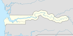
13.255774828056-15.9589716{{{elevation_save}}}Koordinaten: 13° 15′ N, 15° 58′ W
Karte: Gambia
marker
Region: West Coast
Distrikt: Foni Bondali
Einwohner: 111 (2011)

EW1 EW3

Kalang ist eine Ortschaft im westafrikanischen Staat Gambia.

Nach einer Berechnung für das Jahr 2011 leben dort etwa 111 Einwohner, das Ergebnis der letzten veröffentlichten Volkszählung von 1993 betrug 69.[1]

Inhaltsverzeichnis

Geographie

Kalang liegt in der West Coast Region, Distrikt Foni Bondali. Der Ort liegt rund 2,9 Kilometer nördlich von Kanjending, an der South Bank Road.

Kultur und Sehenswürdigkeiten

Bei Kalang ist ein heiliger und religiöser Baum als Kultstätte unter den Namen Kalang bekannt.[2]

Siehe auch

Einzelnachweise

  1. Kalang in World Gazetteer, Zugriff August 2011
  2. Allen Meagher, Andrew Samuel, Baba Ceesay, National Council for the Arts and Culture (Gambia) et al: Historic sites of The Gambia : an official guide to the monuments and sites of The Gambia. National Council for the Arts and Culture, Banjul, The Gambia 1998, ISBN 9983-80-011-014 (formal falsche ISBN)

Wikimedia Foundation.

Игры ⚽ Поможем сделать НИР

Schlagen Sie auch in anderen Wörterbüchern nach:

  • Kalang — Populations Population totale  ? Populations significatives par régions  Indonesie !Indonésie …   Wikipédia en Français

  • Kalang — Kalang, ein nach A. B. Meyer wahrscheinlich zu den Negrito gehöriger, nach andern aber von den Javanen nicht unterschiedener Volksstamm in Java, der gegenüber den malaiischen Javanen eine Art Pariastellung einnimmt …   Meyers Großes Konversations-Lexikon

  • Kalang — Original name in latin Kalang Name in other language Kalang State code PH Continent/City Asia/Manila longitude 5.91972 latitude 121.36306 altitude 39 Population 2323 Date 2012 02 02 …   Cities with a population over 1000 database

  • Kalang-Paya Lebar Expressway — Vorlage:Infobox hochrangige Straße/Wartung/SG E Kalang Paya Lebar Expressway in Singapur Karte …   Deutsch Wikipedia

  • Upper Peirce Reservoir — Infobox lake lake name = Upper Peirce Reservoir image lake = Quincey s shot in 2007.jpg caption lake = image bathymetry = caption bathymetry = location = coords = coord|1|22|03|N|103|48|07|E|region:SG type:waterbody|display=inline,title type =… …   Wikipedia

  • Wayang — is an Indonesian and Malay word for theatre. When the term is used to refer to kinds of puppet theater, sometimes the puppet itself is referred to as wayang. Bayang , the Javanese word for shadow or imagination, also connotes spirit. Performances …   Wikipedia

  • Hartwell railway station, Melbourne — MelbourneRailwayStation1 NAME=Hartwell CODE=HWL DISTANCE=convert|12|km|abbr=on LINES=Alamein PLATFORMS=2 TRACKS=2 STATUS=Unmanned station FACILITIES= [http://www.metlinkmelbourne.com.au/stop/view/19850 Link] TIMETABLES=… …   Wikipedia

  • Tandubas, Tawi-Tawi — Tandubas is a 3rd class municipality in the province of Tawi Tawi, Philippines. According to the 2000 census, it has a population of 24,900 people in 3,935 households.BarangaysTandubas is politically subdivided into 20 barangays. * Baliungan *… …   Wikipedia

  • Liste der Autobahnen in Singapur — Verlauf der Autobahnen in Singapur Liste der Autobahnen in Singapur Autobahn Kurz Name Verlauf Länge AYE …   Deutsch Wikipedia

  • Tandubas — Municipality of Tandubas Lage von Tandubas in der Provinz Tawi Tawi Basisdaten Bezirk …   Deutsch Wikipedia

Share the article and excerpts

Direct link
Do a right-click on the link above
and select “Copy Link”