Kanacea

Kanacea
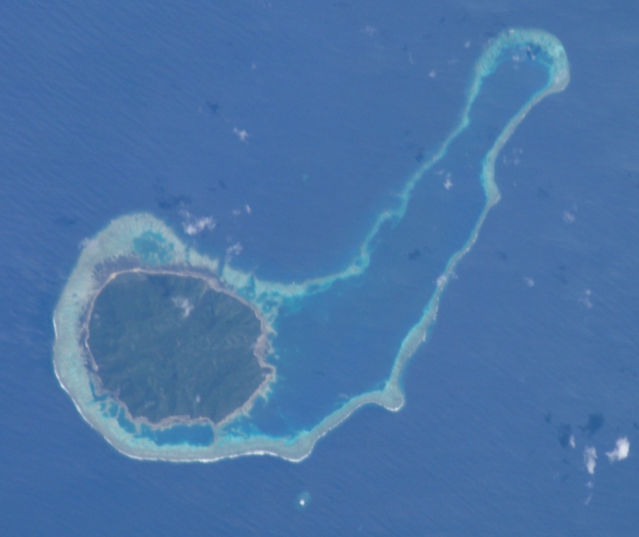
Kanacea
NASA-Astronautenbild von Kanacea
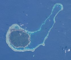
Gewässer Korosee
Inselgruppe Lau-Inseln
Geographische Lage 17° 15′ 56″ S, 179° 9′ 2″ W-17.265555555556-179.15055555556259Koordinaten: 17° 15′ 56″ S, 179° 9′ 2″ W
Kanacea (Fidschi)
Kanacea
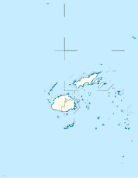
Länge 4,5 km
Breite 4 km
Fläche 13 km²
Höchste Erhebung Thumb Peak
259 m
Einwohner (unbewohnt)

Kanacea [kanaˈðea], auch Kanathea,[Anmerkung 1] ist eine Insel vulkanischen Ursprungs im pazifischen Lau-Archipel. Politisch gehört sie zur Eastern Division des Inselstaates Fidschi.

Inhaltsverzeichnis

Geographie

Kanacea liegt in der Northern Group der Lau-Inseln, 14 km westlich von Vanua Balavu, der zweitgrößten Insel des Archipels sowie 15 km nördlich von Mago. Die annähernd runde Insel ist 4,5 km lang und bis zu 4 km breit. Sie weist eine Fläche von 13 km² auf und erreicht eine Höhe von 259 m über dem Meer.[1] Die Insel ist nahezu vollständig von einem Korallenriff umgeben, das sich weit nach Nordosten bis fast nach Vanua Balavu erstreckt. Kanacea ist in Privatbesitz und nicht dauerhaft bewohnt, im Nordosten der Insel existieren jedoch Plantagengebäude für die Kokosnuss-Ernte, Unterkünfte sowie eine Schule.[2]

Weblinks

Anmerkungen

  1. In Fidschi wird das "c" als "th" (wie im englisch "this") ausgesprochen

Einzelnachweise

  1. UNEP Islands Directory (englisch)
  2. Privatinseln - Kanacea

Wikimedia Foundation.

Игры ⚽ Нужно сделать НИР?

Schlagen Sie auch in anderen Wörterbüchern nach:

  • Kanacea — (pronounced|kanaðea) is a volcanic island with seven peaks in Fiji s Lau archipelago. It is situated at 17.25° South and 179.171° East, 15 kilometers west of Vanua Balavu. Covering an area of 13 square kilometers, it has a maximum elevation of… …   Wikipedia

  • Kanacea — Este artículo está huérfano, pues pocos o ningún artículo enlazan aquí. Por favor, introduce enlaces hacia esta página desde otros artículos relacionados. Kanacea …   Wikipedia Español

  • List of Fiji-related articles — NOTOC Articles (arranged alphabetically) about people, places, things, and concepts related to or originating from Fiji, include: 0 9 2007 Colonial Cup A Rodney ACRAMAN Adi Adi Da James AH KOY Air Fiji Air Pacific Air Pacific destinations Ahmed… …   Wikipedia

  • Mago Island — Coordinates: 17°26′S 179°09′W / 17.433°S 179.15°W / 17.433; 179.15 …   Wikipedia

  • Taveuni — Infobox Mountain Name= Taveuni Photo=TaveuniNASA.jpg Caption=NASA Space Shuttle image of Taveuni. Top of image is NW. Elevation= Convert|1241|m|ft|0|abbr=on Range= Location=Fiji Prominence =Convert|1241|m|ft|0|abbr=on Coordinates =… …   Wikipedia

  • Cicia —   Island   …   Wikipedia

  • Ogea Levu — (pronounced [oˈŋea ˈleβu]) is a coral island on a barrier reef in Fiji s Southern Lau archipelago. With an area of 13.3 square kilometers, it is situated at 19.18° South and 178.47° East, 10 kilometers east of Fulaga. It has a maximum altitude of …   Wikipedia

  • Ogea Driki — (pronounced [oˈŋea ˈndriki]) is a coral atoll (covering approximately 4 square kilometers) in Fiji s Southern Lau Group. It 2.7 kilometers south from Ogea Levu, 10 kilometers east of Fulaga. It is the farming and fishing ground for the Ogean… …   Wikipedia

  • Ono-i-Lau — NASA picture of Ono i Lau. Ono i Lau is a volcanic and coral island in Fiji s Lau archipelago. One of the southernmost of the Lau Islands, it is located at 20.80° South and 178.75° East, and occupies an area of 7.9 square kilometers. It has a… …   Wikipedia

  • Matuku Island — Matuku   Island   …   Wikipedia

Share the article and excerpts

Direct link
Do a right-click on the link above
and select “Copy Link”