Kemps Hill

Kemps Hill
Kemps Hill
Kemps Hill (Jamaika)
Kemps Hill
Kemps Hill
Basisdaten
Staat Jamaika
County Middlesex
Parish Clarendon
Höhe 20 m
ISO 3166-2 JM-13
17.856666666667-77.288611111111

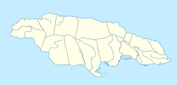
Kemps Hill ist eine kleine Landstadt im Süden von Jamaika. Die Ortschaft befindet sich im County Middlesex im Parish Clarendon. Die genaue Einwohnerzahl ist unbekannt.

Geografie

Kemps Hill befindet sich in der südlichsten Landzunge von Jamaika, wenige Kilometer von der Küste entfernt. Die kultivierte Landschaft um den Ort herum, die für den Anbau von Agrarprodukten genutzt wird, ist eingeebnet und liegt im Durchschnitt 20 Metern über den Meeresspiegel. Das Land flacht Richtung Süden langsam ab. Westlich von Kemps Hill erhebt sich ein Hügel mit einer ungefähren Höhe von 100 Meter über dem Meeresspiegel, von dem der Ort wohl auch seinen Namen erhalten hat.

Die nächsten Ortschaften sind die beiden Siedlungen Caswell Hill und Ashley Hall die ungefähr 3 Kilometer nördlich liegen und sich direkt nebeneinander befinden. Ebenfalls 3 Kilometer jedoch in südlicher Richtung, befinden sich die ebenfalls nebeneinander liegenden Ortschaften Race Course und Gowrie. Der größte Ort im Umkreis ist das circa 9 Kilometer entfernte Hayes im Norden.

Schulen

Trotz seiner geringen Größe befindet sich in Kemps Hill die Kemps Hill High, eine überregional bekannte High School.

Siehe auch


Wikimedia Foundation.

Игры ⚽ Поможем решить контрольную работу

Schlagen Sie auch in anderen Wörterbüchern nach:

  • Kemps Creek, New South Wales — Infobox Australian Place | type = suburb name = Kemps Creek city = Sydney state = NSW caption = lga = City of Penrith lga2 = City of Liverpool postcode = 2178 est = pop = area = propval = stategov = Smithfield fedgov = Prospect near nw = Orchard… …   Wikipedia

  • Race Course — Race Course …   Deutsch Wikipedia

  • Contenu:Australie — Projet:Australie/Liste des articles Liste mise à jour régulièrement par MyBot (d · c · b) à partir des articles liés au bandeau {{Portail Australie}} Modifications récentes des articles ayant le bandeau de ce portail… …   Wikipédia en Français

  • Brigades of the NSW RFS — Brigades of the New South Wales Rural Fire Service Listing by Rural Fire District [http://www.bluemountains.rfs.nsw.gov.au/ Blue Mountains District] * Bell * Blackheath / Mt Victoria * Blaxland * Bullaburra * Faulconbridge * Glenbrook Lapstone *… …   Wikipedia

  • Badgerys Creek, New South Wales — Infobox Australian Place | type = suburb name = Badgerys Creek city = Sydney state = nsw postcode= 2555 caption = pop = 721 (2006) lga = City of Liverpool stategov = Mulgoa fedgov = Macarthur near nw = Orchard Hills near n = Orchard Hills near ne …   Wikipedia

  • Catholic Education in the Diocese of Parramatta — There has been Catholic Education in the Diocese of Parramatta since before the Second World War. There are 76 Catholic systemic schools in the diocese (54 primary and 22 secondary) with a total student population of around 41,000. There are also …   Wikipedia

  • Eric Waldram Kemp — (* 27. April 1915 in Waltham; † 28. November 2009 in Chichester[1]) war ein britischer anglikanischer Geistlicher und Bischof der Church of England. Inhaltsverzeichnis 1 Ausbildung 2 Kirchlich …   Deutsch Wikipedia

  • List of Bahamas-related topics — This is a list of topics related to The Bahamas. Those interested in the subject can monitor changes to the pages by clicking on Related changes in the sidebar.Bahamas* The Bahamas * Bahamians * College of the Bahamas * Roman Catholic Archdiocese …   Wikipedia

  • South Creek, New South Wales — South Creek is the name for a Township in New South Wales, as well as the creek that ran through it.TownshipThe township of South Creek used to exist where the creek joins the Hawkesbury River. The name only existed for a few years in the early… …   Wikipedia

  • City of Penrith — New South Wales Population: 184,611(2009) …   Wikipedia

Share the article and excerpts

Direct link
Do a right-click on the link above
and select “Copy Link”