Kermadec Marine Reserve

Kermadec Marine Reserve
-29.283333333333-177.91666666667
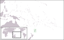
Lage der Kermadecinseln

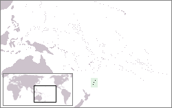
Das Kermadec Marine Reserve, auch Kermadec Islands Marine Reserve (KIMR), ist das größte Meeresschutzgebiet Neuseelands.

Es umfasst die Gewässer im Archipel der nördlich der Nordinsel liegenden Kermadecinseln, von der Inselküste bis zu einer Entfernung von 12 Seemeilen. Es beinhaltet somit eine Fläche von 745.000 ha (7450 km²). Das Kermadec Marine Reserve wurde im November 1990 gegründet und wird vom neuseeländischen Department of Conservation verwaltet.

Weblinks


Wikimedia Foundation.

Игры ⚽ Поможем написать реферат

Schlagen Sie auch in anderen Wörterbüchern nach:

  • Kermadec Islands — since 1887.The islands lie within 29° to 31.5° south latitude and 178° to 179° west longitude, 800 ndash; 1000 km northeast of New Zealand s North Island, and a similar distance southwest of Tonga. The centre of the Kermadec Islands group is… …   Wikipedia

  • Marine reserves of New Zealand — New Zealand has over thirty marine reserves spread around the North, the South Island, and neighbouring islands, and another two on outlying island groups. They are governed by the Marine Reserves Act 1971 and administered by the Department of… …   Wikipedia

  • Curtis Island (Kermadec Islands) — Curtis Island is an island in the southwest Pacific (located at coord|30|33|S|178|34|W|). It is a volcanic island with an elevation of 130 m and an area of 0.6 km². Together with neighboring Cheeseman Island it belongs to the Kermadec Islands.… …   Wikipedia

  • Îles Kermadec — Pour les articles homonymes, voir Kermadec. Îles Kermadec Kermadec Islands (en) …   Wikipédia en Français

  • Iles Kermadec — Îles Kermadec Îles Kermadec Kermadec Islands (en) Carte des îles Kermadec. Géographie Pays …   Wikipédia en Français

  • Cheeseman Island — (rechts) und Curtis Island von Norden aus Gewässer …   Deutsch Wikipedia

  • Curtis Island, New Zealand — Curtis Island Crater Curtis Island Curtis Island (left) and Cheeseman Isla …   Wikipedia

  • Curtis Island — Der Krater auf Curtis Island Gewässer Pazifischer Ozean Inselgruppe …   Deutsch Wikipedia

  • Cheeseman Island — (right) and Curtis Island from north. Map Geography …   Wikipedia

  • Kermadecinseln — Karte der Kermadec Inseln Gewässer Pazifischer Ozean Geographi …   Deutsch Wikipedia

Share the article and excerpts

Direct link
Do a right-click on the link above
and select “Copy Link”