Kitikmeot, Unorganized

Kitikmeot, Unorganized
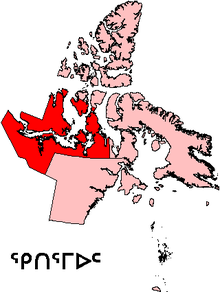
Die Region Kitikmeot in Nunavut

Die Census Division Kitikmeot, Unorganized ist ein Teil der Region Kitikmeot in Nunavut, das im Norden Kanadas liegt. Sie dient rein statistischen Zwecken und ist unbewohnt.

Kitikmeot, Unorganized ist eine census division. Eine solche Einheit liegt unterhalb der Ebene der Provinzen und Territorien und kann verschiedene organisatorische Einheiten, wie county, regional municipality oder regional district umfassen. Die insgesamt 288 divisions dienen in einigen Provinzen der übergreifenden Planung gemeinsamer Vorhaben und der Organisation staatlicher Strukturen, wie etwa Krankenversorgung oder Polizei. Andernorts handelt es sich um Einheiten, die ausschließlich statistischen Zwecken dienen.[1] Dies gilt für Neufundland und Labrador, Manitoba, Saskatchewan, Alberta, Yukon, die Nordwest-Territorien und für Nunavut.

Kitikmeot, Unorganized heißt deshalb „Unorganized“, weil es im Gegensatz zu Kitikmeot, das eine Fläche von 445.785,4 km² aufweist, nur diejenigen Gebiete umfasst, die ohne Siedlungen sind. Dabei zählte man für die Division Kitikmeot, Unorganized 1981 24 Einwohner, 1986 zählte man 13, 1991 waren es nur noch 2 Einwohner. Seither gilt das Gebiet als unbewohnt.[2]

Anmerkungen

  1. Statistics Canada
  2. Statistics Canada und Nunavut Census population by region and community, 1981 Census to 2006 Census (2 tables).xls.

Wikimedia Foundation.

Игры ⚽ Нужно сделать НИР?

Schlagen Sie auch in anderen Wörterbüchern nach:

  • Kitikmeot, Unorganized — est un territoire non organisé situé dans la région de Kitikmeot dans le territoire canadien du Nunavut. Ce territoire non organisé couvre l ensemble du territoire de la région à l extérieur des communautés. Il n y a aucune communauté située à l… …   Wikipédia en Français

  • Kitikmeot, Unorganized — is part of the Kitikmeot census division in Nunavut, Canada. This area covers the entire Kitikmeot Region outside of the communities. There are no communities included in this area and it would cover traditional and outpost camps.Demographics… …   Wikipedia

  • Kitikmeot Region, Nunavut — Kitikmeot Region (Inuktitut: Qitirmiut ᕿᑎᕐᒥᐅᑦ) is an administrative region of Nunavut. It consists of the southern and eastern parts of Victoria Island with the adjacent part of the mainland as far as the Boothia Peninsula, together with King… …   Wikipedia

  • Kitikmeot — (Inuktitut: Qitirmiut ᕿᑎᕐᒥᐅᑦ) can refer to:* Kitikmeot Region, Nunavut, a region of Nunavut. ** Kitikmeot, Unorganized, a census subdivision, consisting of those parts of the Kitikmeot Region outside communities * Kitikmeot Region, Northwest… …   Wikipedia

  • Kitikmeot — 68°55′N 100°45′W / 68.917, 100.75 …   Wikipédia en Français

  • List of communities in Nunavut — This is a list of communities in Nunavut Territory, Canada. Note that many of these communities have alternate names or spellings in Inuktitut or Inuinnaqtun, while others are primarily known by their Inuktitut or Inuinnaqtun names. As of the… …   Wikipedia

  • Croker River — Mouth Amundsen Gulf 69°07′31″N 119°30′07″W /  …   Wikipedia

  • Umingmaktok — Umingmaktuuq   Settlement   Umingmaktuuq looking towards the Co op store …   Wikipedia

  • Qikiqtaaluk Region — Qikiqtaaluk Region, Qikiqtani Region (Inuktitut: ᕿᑭᖅᑖᓗᒃ) or Baffin Region is an administrative region of Nunavut, Canada. Qikiqtaaluk is the traditional Inuktitut name for Baffin Island. Although Qikiqtaaluk Region is the most commonly used name… …   Wikipedia

  • Mansel Island — [[Inuktitut|Native name]]: Pujjunaq Mansel Island, Nunavut Geography Location Hudson Bay …   Wikipedia

Share the article and excerpts

Direct link
Do a right-click on the link above
and select “Copy Link”