Kumara Junction

Kumara Junction

p1

Kumara Junction
Kumara Junction (Neuseeland)
Kumara Junction
Koordinaten 42° 35′ S, 171° 8′ O-42.585128284167171.12944126139Koordinaten: 42° 35′ S, 171° 8′ O
Region West Coast
Distrikt Westland-Distrikt
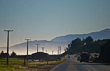
SH 6 bei Kumara Junction

Kumara Junction ist eine kleine Ansiedlung in der Region West Coast im Westen der Südinsel Neuseelands. Hier zweigt der State Highway 73 (SH 73) in Richtung Westen vom State Highway 6 ab. Die Greymouth und Hokitika verbindende Eisenbahn-Nebenlinie Hokitika Branch hat hier einen Haltepunkt.

Kumara Junction liegt südlich der Mündung des Taramakau River in die Tasmansee und 18 Straßenkilometer südsüdöstlich vom Stadtzentrum von Greymouth, der größten Stadt der Westküste. Nächstgelegene Ortschaft am SH 6 Richtung Süden ist Chesterfield, Richtung Norden Camerons und am SH 73 Richtung Westen Kumara.

Der Name des Ortes entstand nicht aus den in Neuseeland bekannten Namen der Māori „Kumara“ für die Süßkartoffel, sondern aus „Kuhimara“ oder „Kohe mara“ , dem Namen der Ureinwohner für die Blüte der in Neuseeland heimischen, kletternden Brombeerpflanze Bush Lawyer oder tātarāmoa[1][2], nach anderen Quellen einer anderen Pflanze, Convolvulvus arvenis.[3]

Literatur/Quellen

Einzelnachweise

  1. Das Neuseelandbuch, NZ Visitor Publications Ltd., Nelson 2003 S. 978 ISBN 1-877339-00-8
  2. [http://www.teara.govt.nz/en/1966/kumara-westland/1 Te Ara - An Encoclopedia of New Zealand 1966, abgerufen 21. Januar 2011
  3. Das Neuseelandbuch, NZ Visitor Publications Ltd., Nelson 2003 S. 978 ISBN 1-877339-00-8

Wikimedia Foundation.

Игры ⚽ Поможем написать курсовую

Schlagen Sie auch in anderen Wörterbüchern nach:

  • Kumara (Neuseeland) — Kumara …   Deutsch Wikipedia

  • New Zealand State Highway 73 — State Highway 73 Great Alpine Highway, Christchurch Ring Road Route information Maintained by …   Wikipedia

  • New Zealand State Highway 6 — State Highway 6 Route information Maintained by …   Wikipedia

  • New Zealand State Highway 6 — Straßenschild des SH 6 Lage des SH 6 auf der Südinsel …   Deutsch Wikipedia

  • New Zealand State Highway network — The New Zealand State Highway Shield. The New Zealand State Highway network is the major national highway network in New Zealand. Just under 100 roads in both the North and South Islands are State Highways. All state highways are administered by… …   Wikipedia

  • Greymouth — Greymouth …   Deutsch Wikipedia

  • Birdsong Backpackers — (Hokitika,Новая Зеландия) Категория отеля: Адрес: 2/124 Kumara Junction Highwa …   Каталог отелей

  • Ross Branch — The Ross Branch, now known as the Hokitika Branch (and officially as the Hokitika Industrial Line), is a branch line railway that forms part of New Zealand s national rail network. It is located in the Westland District of the South Island s West …   Wikipedia

  • Mervyn Silva — Honourable Mervyn Silva MP Deputy Minister of Highways In office 5 May 2010 – 10 August 2010 Incumbent …   Wikipedia

  • Palmerston, New Zealand — for the North Island city see Palmerston North PalmerstonUrban AreaPopulation 1,020 (2001)Territorial AuthorityName Waihemo Ward of Waitaki DistrictPopulation Around 2,500 (2004 est.)ExtentIncludes the town of Palmerston.Regional CouncilNameOtago …   Wikipedia

Share the article and excerpts

Direct link
Do a right-click on the link above
and select “Copy Link”