Lac Minto

Lac Minto
Lac Minto

Photo-request.svg

Bild gesucht 

BW

Geographische Lage Nunavik in Québec (Kanada)
Zuflüsse Rivière Charpentier
Abfluss Rivière aux Feuilles
Daten
Koordinaten 57° 13′ N, 75° 1′ W57.218611111111-75.0125168Koordinaten: 57° 13′ N, 75° 1′ W
Lac Minto (Québec)
Lac Minto
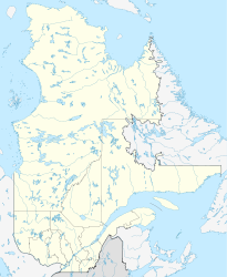
Höhe über Meeresspiegel 168 m
Fläche 703 km² (einschl. Inseln 761 km²)dep1f5
Länge 81 kmf6
Breite 22 kmf7

Lac Minto (englisch Lake Minto, Inuktitut: Qasigialik („wo es Largha-Robben gibt“)) ist ein See im Westen der Ungava-Halbinsel, in der Region Nunavik in der kanadischen Provinz Québec. Er hat eine Gesamtfläche (einschließlich Inseln) von 761 km² und eine Wasserfläche von 703 km².[1]

Er wurde vom kanadischen Entdecker und Geologen Albert Peter Low im Jahre 1898 nach Gilbert Elliot-Murray-Kynynmound, 4. Earl of Minto benannt, der zu dieser Zeit Generalgouverneur von Kanada war.[2]

Er befindet sich lediglich 60 km östlich der Hudson Bay in einem Tal von mehreren Hügelketten eingerahmt. Sein Abfluss, der Rivière aux Feuilles, fließt etwa 265 km nach Nordosten zur Ungava Bay. Er eignet sich deshalb für Kanuten, die die Ungava-Halbinsel in östlicher Richtung durchqueren wollen.[2][3][4]

Er gilt als einer der schönsten Seen im nördlichen Québec.[2]

Einzelnachweise

  1. Natural Resources Canada, Atlas of Canada - Lakes
  2. a b c Lac Minto (French). Commission de toponymie du Québec. Abgerufen am 13. Dezember 2010.
  3. http://www.bassioutdoors.com/NUCE.html Northern Ungava Canoe Expedition
  4. http://www.nrsweb.com/services/newsletter/2007/rtnStory_0207b.asp Crossing the Ungava

Wikimedia Foundation.

Игры ⚽ Нужен реферат?

Schlagen Sie auch in anderen Wörterbüchern nach:

  • Lac Minto — Sp Minto ẽžeras Ap Lac Minto L Kanadoje (Kvebekas) …   Pasaulio vietovardžiai. Internetinė duomenų bazė

  • Minto ežeras — Sp Minto ẽžeras Ap Lac Minto L Kanadoje (Kvebekas) …   Pasaulio vietovardžiai. Internetinė duomenų bazė

  • Minto Inlet — is located east of Amundsen Gulf in western Victoria Island, at the southern end of Prince of Wales Strait in the Northwest Territories. It is 75 miles (121 km) long and 8 miles (13 km) 25 miles (40 km) wide.[1] The inlet is part… …   Wikipedia

  • Minto (nouveau-brunswick) — Pour les articles homonymes, voir Minto. Minto Ajouter une image Administration …   Wikipédia en Français

  • Minto (circonscription électorale) — Minto Circonscription électorale provinciale Données clés Province  Manitoba (  Canada) Député …   Wikipédia en Français

  • Lac-du-Bonnet (circonscription électorale) — Lac du Bonnet Circonscription électorale provinciale Données clés Province  Manitoba (  Canada) Député …   Wikipédia en Français

  • Minto (Nouveau-Brunswick) — Pour les articles homonymes, voir Minto. Minto L école secondaire Minto Memorial Administration …   Wikipédia en Français

  • Minto (electoral district) — The 2011+ boundaries for Minto highlighted in red. Minto is a provincial electoral division in the Canadian province of Manitoba. It was created by redistribution in 1999, and has formally existed since the provincial election of 1999. The riding …   Wikipedia

  • Lac George (comté de Queens) — Pour les articles homonymes, voir Baker. Lac Antinouri Administration Pays …   Wikipédia en Français

  • Lago Minto — País  Canadá Localización Kativik, Quebec Coordenadas …   Wikipedia Español

Share the article and excerpts

Direct link
Do a right-click on the link above
and select “Copy Link”