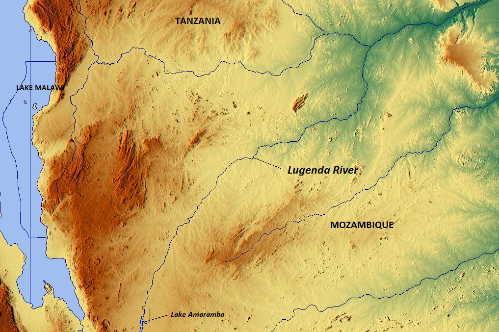
Lugenda

Lugenda
Lugenda
Lugenda River.png

Vorlage:Infobox Fluss/KARTE_fehlt

DatenVorlage:Infobox Fluss/GKZ_fehlt
Lage Provinz Niassa, Mosambik
Flusssystem Rovuma
Abfluss über Rovuma → Indischer Ozean
Quelle Chiutasee
14° 40′ 45″ S, 35° 52′ 10″ O-14.67925389520535.869331359863
Vorlage:Infobox Fluss/QUELLHÖHE_fehlt
Mündung bei Negomano in den Rovuma
-11.42805555555638.488888888889

11° 25′ 41″ S, 38° 29′ 20″ O-11.42805555555638.488888888889
Vorlage:Infobox Fluss/MÜNDUNGSHÖHE_fehltVorlage:Infobox Fluss/HÖHENUNTERSCHIED_fehltVorlage:Infobox Fluss/LÄNGE_fehltVorlage:Infobox Fluss/EINZUGSGEBIET_fehlt

Vorlage:Infobox Fluss/ABFLUSS_fehlt

Durchflossene Seen Amaramba-See

Der Lugenda ist ein Fluss in Mosambik. Er ist der größte rechte Nebenfluss des Rovuma.

Er entspringt im Chiutasee an der Grenze zu Malawi, durchquert mäandrierend in Nordostrichtung die Provinz Niassa und den Amaramba-See und mündet beim Dorf Negomano an der tansanischen Grenze in den Rovuma. 360 km davon fließt er durch die Niassa Game Reserve. Neben dem Tourismus ist der Lugenda vor allem für den Fischfang von großer regionaler Bedeutung. Er ist umsäumt von bewaldetem Grünland und weist viele Stromschnellen und Seitenarme auf. Der Wasserstand ist in der Trockenzeit meist sehr niedrig.

Weblinks


Wikimedia Foundation.

Игры ⚽ Нужно сделать НИР?

Schlagen Sie auch in anderen Wörterbüchern nach:

  • Lugenda — 14° 40′ 45″ S 35° 52′ 10″ E / 14.6792539, 35.86933136 …   Wikipédia en Français

  • Negomano — Negomano …   Wikipedia

  • Río Rovuma — Saltar a navegación, búsqueda otros usosRuvuma (región) Río Ruvuma (o Rovuma) País que atraviesa …   Wikipedia Español

  • Amaramba-See — Bild gesucht  BW Geographische Lage Ostafrikanischer Graben Zuflüsse …   Deutsch Wikipedia

  • Chiuta-See — Bild gesucht  BW Geographische Lage Malawi, Mosambik Zuflüsse …   Deutsch Wikipedia

  • Lac Amaramba — Administration Pays  Mozambique Géographie …   Wikipédia en Français

  • Geography of Malawi — Malawi s cities, towns and larger villages Satellite image of Malawi …   Wikipedia

  • Maputo River — The Maputo River (Portuguese Rio Maputo), also called Great Usutu River, Lusutfu River or Suthu River, is a river in South Africa, Swaziland and Mozambique. The name Suthu refers to Basotho people who lived near the source of the river, who were… …   Wikipedia

  • Yao (ethnic group in Africa) — ethnic group group=Yao 9 to 10 year old boys of the Yao tribe participating in circumcision and initiation rites (March 2005). poptime= 2 million popplace=Malawi, Mozambique, Tanzania rels=Islam langs=Chiyao, Chichewa, Chitimbuka, Swahili,… …   Wikipedia

  • Save River (Africa) — A view of the Save in Mozambique The Save (or Sabi) is a 400km river of southeastern Africa, flowing through Zimbabwe and Mozambique. The river has its source in Zimbabwe, some 80 km south of Harare, then flows south and then east, from the… …   Wikipedia

Share the article and excerpts

Direct link
Do a right-click on the link above
and select “Copy Link”