Matancillas de San Antonio

Matancillas de San Antonio
Basisdaten
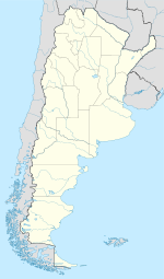
Lage 22° 50′ S, 64° 55′ W-22.826667-64.9152781520Koordinaten: 22° 50′ S, 64° 55′ W
Höhe ü. d. M.: 1.520 m
  (Argentinien)
 
 
Verwaltung
Provinz: Salta
Departamento: Iruya
Gemeinde: Iruya
Sonstiges
Postleitzahl: A4633

Matancillas de San Antonio (auch einfach Matancillas) ist ein kleines Dorf im Nordwesten Argentiniens. Es gehört zum Departamento Iruya in der Provinz Salta und liegt in 1.520 m Höhe, am Fluss Iruya, etwa 40 km vom Dorf Iruya entfernt.[1]

Das Klima in Matancillas ist subtropisch.[2]

Das Dorf hat eine Schule mit etwa 55 Schülern.[3]

Siehe auch

Matancillas del Valle Delgado

Einzelnachweise

  1. http://www.portaldesalta.gov.ar/iruyacircuitos.htm
  2. http://novoyatirarlatoalla.blogdiario.com/tags/solidario/
  3. http://www.lanacion.com.ar/nota.asp?nota_id=394389

Wikimedia Foundation.

Игры ⚽ Поможем написать реферат

Schlagen Sie auch in anderen Wörterbüchern nach:

  • Matancillas — ist: in Argentinien Matancillas de San Antonio ein Ort in der Nähe von San Antonio im Departamento Iruya der Provinz Salta Matancillas del Valle Delgado ein Ort in der Nähe von Rodio del Valle Delgado im Departamento Iruya der Provinz Salta in… …   Deutsch Wikipedia

  • Iruya (Gemeinde) — Iruya ist eine Gemeinde (Municipio) im gleichnamigen Departamento Iruya in der Provinz Salta im Nordwesten Argentiniens.[1] Orte der Gemeinde Sie umfasst die Orte Iruya, San Isidro, Casa Grande, Rodeo Colanzulí, La Mesada, San Pedro, Matancillas… …   Deutsch Wikipedia

  • Chronologie des alternatives (1961 à 1980) — Sommaire 1 1961 2 1962 3 1963 4 1964 5 1965 …   Wikipédia en Français

  • Taltal — Escudo …   Wikipedia Español

Share the article and excerpts

Direct link
Do a right-click on the link above
and select “Copy Link”