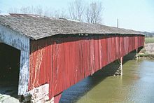
Medora Covered Bridge

Medora Covered Bridge
Medora Covered Bridge (2006)

Die Medora Covered Bridge ist eine historische überdachte ehemalige Straßenbrücke im Jackson County, im US-Bundesstaat Indiana, in den Vereinigten Staaten. Die 1875 errichtete Brücke, die im Burr Truss-Design gestaltet ist, befindet sich etwa einen Kilometer südöstlich von Medora, abseits der Indiana State Road 235. Sie überspannt den East Fork White River.

Die Gesamtlänge der Medora Covered Bridge beträgt 132,3 Meter. Die Brücke ist seit 1972 für den Fahrzeugverkehr gesperrt, bleibt jedoch für Fußgänger offen. Das Fundament besteht aus Kalkstein, die Wände sind holzverschalt und der Dach besteht aus Stahl. Architekt war Joseph J. Daniels.

Die Medora-Brücke wurde vom National Register of Historic Places mit der Nummer 07000977 am 19. September 1977 aufgenommen.[1][2]

Weblinks

Einzelnachweise

  1. NRIS
  2. Medora Covered Bridge, Jackson County, Indiana
38.818623-86.147341

Wikimedia Foundation.

Игры ⚽ Поможем решить контрольную работу

Schlagen Sie auch in anderen Wörterbüchern nach:

  • Medora Covered Bridge — U.S. National Register of Historic Places …   Wikipedia

  • Medora (Indiana) — Medora …   Deutsch Wikipedia

  • Medora — ist der Name mehrerer Orte in den Vereinigten Staaten: Medora (Illinois) Medora (Indiana) Medora (Iowa) Medora (Kansas) Medora (Kentucky) Medora (North Dakota) Medora Township (Kansas) Siehe auch: Medora Covered Bridge …   Deutsch Wikipedia

  • Medora, Indiana —   Town   Location of Medora in th …   Wikipedia

  • National Register of Historic Places listings in Jackson County, Indiana — Location of Jackson County in Indiana This is a list of the National Register of Historic Places listings in Jackson County, Indiana. This is intended to be a complete list of the properties and districts on the National Register of Historic… …   Wikipedia

  • Jackson County, Indiana — Location in the state of Indiana …   Wikipedia

  • Indiana State Road 235 — Infobox road state=IN type=IN route=235 alternate name= length mi=7.5 length round=1 length ref= [http://illi indi.com/EndsPage.php?id=1235 section=1 Indiana Highway Ends SR 235] ] established= direction a=South starting terminus= junction=… …   Wikipedia

  • Quality Inn Seymour — (Seymour,США) Категория отеля: 2 звездочный отель Адрес: 2075 East Tipton Street …   Каталог отелей

  • Jackson County (Indiana) — Verwaltung US Bundesstaat: Indiana Verwaltungssitz: Brownstown Gründung: 1816 Demographie Einwohner: 41.335  (2000) …   Deutsch Wikipedia

  • Murphy Mound Archeological Site — U.S. National Register of Historic Places U.S. National Historic Landmark …   Wikipedia

Share the article and excerpts

Direct link
Do a right-click on the link above
and select “Copy Link”